Name/Title
Waterfront Park [Landscape Plan]Entry/Object ID
2019.001.3Scope and Content
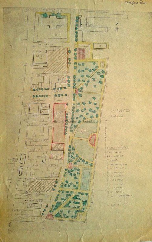
Map/landscape plan of Waterfront Park possibly created after the publication of the Charleston Waterfront Park Master Plan. Creator of original map not indicated. It has been hand-colored by Historic Charleston Foundation. Shows the area bounded by South Adger's Wharf, East Bay Street, Market Street, and the Cooper River, with building footprints.
Indicates "Existing Uses": Pilot House, Exchange buildings, Perdita's, Carolina Shipping, Luden's building, Colony House, S.C. Tax Commission building, U.S.N. landing, SCSPA building, U.S. Customs building, gas stations, and major parking areas.
Scale: 1" = 100'Collection
HCF Map CollectionAcquisition
Accession
2019.001Source or Donor
New Archives Catalog Records (2019)Acquisition Method
Collected by StaffLexicon
Search Terms
Park maps/highway maps, Landscape plans, landscape drawings, Waterfront Park (Charleston, S.C.)--Designs and plans, Parks--South Carolina--Charleston--Designs and plansLegacy Lexicon
Object Name
Plan, Landscape (Garden)Archive Details
Date(s) of Creation
circa 1980Archive Size/Extent
2 copies of map : 17" x 24"Archive Notes
Date(s): ca. 1980Location
Location
Container
FolderDrawer
Drawer 4Cabinet
Blueprints-Maps 5Room
Margaretta P. Childs ArchivesBuilding
Missroon HouseCategory
PermanentDate
February 7, 2023Condition
Notes
Tear at bottom right corner.Created By
admin@catalogit.appCreate Date
February 7, 2019Updated By
admin@catalogit.appUpdate Date
February 16, 2023