Name/Title
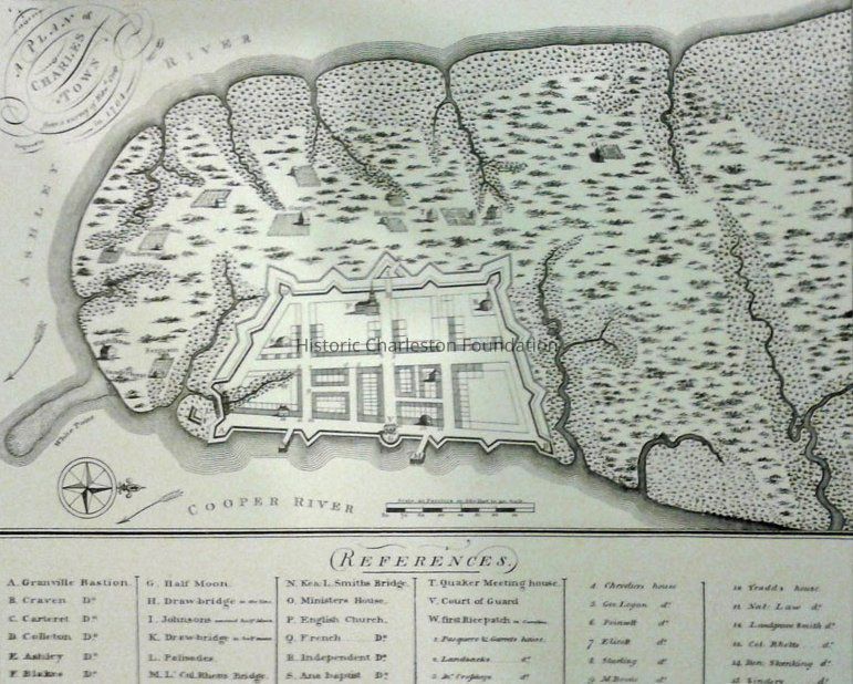
A Plan of Charles Town, from a Survey of Edward Crisp in 1704, Engraved by James AkinsEntry/Object ID
2019.001.14Scope and Content
Reproduction of a survey of Edward Crisp in 1704 featuring the land on the Charleston peninsula land and the fortified city, a/k/a "Walled City." Includes references (index) to notable buildings and other features.
Reproduced in 1969 by Historic Urban Plans ... from the original in the Cornell University Library.
Digitized map available from Library of Congress Digital Collecitons at https://www.loc.gov/maps/?fa=contributor:crisp,+edw&q=crisp.Collection
HCF Map CollectionAcquisition
Accession
2019.001Source or Donor
New Archives Catalog Records (2019)Acquisition Method
Collected by StaffLexicon
Nomenclature 4.0
Nomenclature Secondary Object Term
MapNomenclature Primary Object Term
CartographNomenclature Sub-Class
Graphic DocumentsNomenclature Class
Documentary ObjectsNomenclature Category
Category 08: Communication ObjectsSearch Terms
Historic maps of Charleston, Wall Street, Charleston (S.C.)--MapsArchive Details
Creator
Crisp, Edw. (Edward)Archive Size/Extent
Reproduction of original map, 13" x 15"Archive Notes
Date(s) Created: 1704, 1969
Date(s): 1704 (date of original)Location
Location
Container
FolderDrawer
Drawer 4Cabinet
Blueprints-Maps 5Room
Margaretta P. Childs ArchivesBuilding
Missroon HouseCategory
PermanentDate
February 7, 2023Created By
admin@catalogit.appCreate Date
February 19, 2019Updated By
admin@catalogit.appUpdate Date
February 16, 2023