Name/Title
Map of the Seat of War in South Carolina and GeorgiaEntry/Object ID
2019.001.16Scope and Content
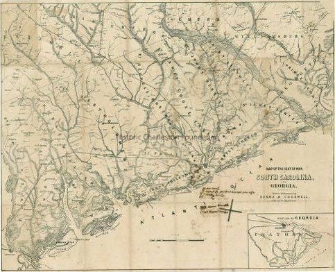
Reproduction of the 1861 Map of the Seat of War in South Carolina and Georgia, published and lithographed by Evans & Cogswell. Shows the coastal area from Georgetown, South Carolina, to Savannah, Georgia, and territory inland as far north as Kingstree, South Carolina, to Orangeburg, South Carolina. Gives the location of forts and shows coastal shoals, drainage, roads, railroads, ferries, bridges, dwellings with names of inhabitants, churches, and post offices. Inset shows a portion of Georgia [around Savannah].
Reprint distributed by G.W. Aimar & Co., 1970.
Digitized original maps on Library of Congress Digital Collections (Maps).Collection
HCF Map CollectionAcquisition
Accession
2019.001Source or Donor
New Archives Catalog Records (2019)Acquisition Method
Collected by StaffLexicon
Nomenclature 4.0
Nomenclature Secondary Object Term
MapNomenclature Primary Object Term
CartographNomenclature Sub-Class
Graphic DocumentsNomenclature Class
Documentary ObjectsNomenclature Category
Category 08: Communication ObjectsSearch Terms
South Carolina (S.C.)--History--Civil War, 1861-1865--MapsArchive Details
Date(s) of Creation
1861Archive Size/Extent
1 map, 22" x 27"Archive Notes
Date(s): 1861 (date of original)Location
Location
Container
Misc. Plats & MapsDrawer
Drawer 1Cabinet
Blueprints-Maps 6Room
Margaretta P. Childs ArchivesBuilding
Missroon HouseCategory
PermanentDate
February 7, 2023Created By
admin@catalogit.appCreate Date
February 19, 2019Updated By
admin@catalogit.appUpdate Date
February 16, 2023