Name/Title
Aerial View of the Standard Oil RefineryEntry/Object ID
2021.012.3Description
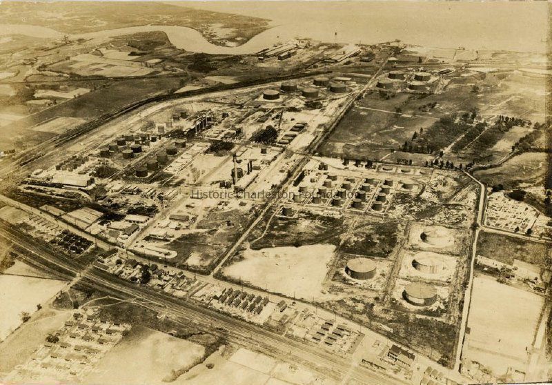
Aerial photograph of the Standard Oil Refinery, which was located north of Magnolia Cemetery, bounded by upper Meeting Street on the west. Shows the tanks (some of which are extant), industrial buildings, housing units, Belvidere Plantation (also known as Belvedere Plantation), and other buildings (some of which are extant). Also shows Laurel Island (upper left) and the Cooper River (background).
The photo, which appeared in the Evening Post newspaper on April 29, 1926, is captioned: "The air view shows the big refinery established by the Standard Oil Co. on the Cooper river several years ago, there being seen the stills, storage tanks, various buildings, athletic grounds, and the former country club and other property recently added to the territory covered by the extensive plant."Collection
HCF Image CollectionAcquisition
Accession
2021.012Source or Donor
Eberle, KevinAcquisition Method
GiftCredit Line
Courtesy of Kevin EberleLexicon
Nomenclature 4.0
Nomenclature Primary Object Term
PhotographNomenclature Sub-Class
Graphic DocumentsNomenclature Class
Documentary ObjectsNomenclature Category
Category 08: Communication ObjectsLOC Thesaurus for Graphic Materials
Aerial photographsSearch Terms
AerialViews/Photographs, Standard Oil Refinery (Charleston, S.C.), Oil refineries--South Carolina--CharlestonDimensions
Height
6-3/4 inWidth
4-1/2 inLocation
Location
Room
Margaretta P. Childs ArchivesBuilding
Missroon HouseCategory
PermanentDate
February 7, 2023Copyright
Copyright Details
Public domain.General Notes
Note
Notes: Description notes from Kevin Eberle. See Media tab for annotaged photograph.Created By
admin@catalogit.appCreate Date
April 6, 2021Updated By
sferguson@historiccharleston.orgUpdate Date
May 24, 2023