Name/Title
Mills' Atlas of South Carolina: An Atlas of the Districts of South Carolina in 1825 Compiled by Robert Mills, Engineer and ArchitectEntry/Object ID
2012.010.182Secondary Title
Mills Atlas of South CarolinaDescription
Limited edition reproduction of cartographer Robert Mills' Atlas, "faithfully reproduced from the original engravings and includes an introduction by Charles E. Lee, Director, South Carolina Archives Department."
Folder 1
Sleeve 1: Title Page -- Preface
Sleeve 2: Introduction -- "Atlas of the State of South Carolina"
Sleeve 3: Abbeville District -- Barnwell District
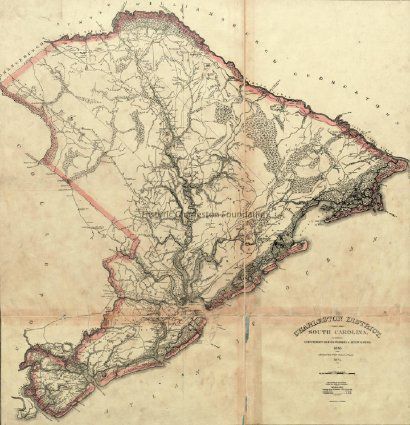
Sleeve 4: Beaufort District -- Charleston District
Sleeve 5: Chester District -- Chesterfield District
Sleeve 6: Colleton District -- Darlington District
Folder 2
Sleeve 7: Edgefield District -- Fairfield District
Sleeve 8: Georgetown District -- Greenville District
Sleeve 9: Horry District -- Kershaw District
Sleeve 10: Lancaster District -- Laurens District
Sleeve 11: Lexintgon District -- Marion District
Folder 3
Sleeve 12: Marlborough District -- Newberry District
Sleeve 13: Orangeburg District -- Pendleton District
Sleeve 14: Richland District -- Spartanburg District
Sleeve 15: Sumter District -- Union District
Sleeve 16: Williamsburt District -- York District
[3] l., 29 maps (part fold., part col.) ; 75 cm.Collection
Historic Charleston Foundation LibraryAcquisition
Accession
2012.010.Source or Donor
Estate of Emily Ravenel FarrowAcquisition Method
BequestLexicon
Nomenclature 4.0
Nomenclature Primary Object Term
BookNomenclature Sub-Class
Other DocumentsNomenclature Class
Documentary ObjectsNomenclature Category
Category 08: Communication ObjectsSearch Terms
Geography, Atlases, South Carolina--MapsBook Details
Author
Mills, Robert, 1781-1855Publisher
Robert Pearce Wilkins & John D. KeelsDate Published
1965Call No.
G1305 .M53 1965Notes
Copy No.: 1Location
Location
Drawer
Drawer 1Cabinet
Blueprints-Maps 6Room
Margaretta P. Childs ArchivesBuilding
Missroon HouseCategory
PermanentDate
February 7, 2023Relationships
Related Entries
Notes
2007.002.0065, 2012.010.055Related Publications
Notes
Digitized, South Carolina Digital LibraryGeneral Notes
Note
Notes: Scale of district maps 1:126,720; 2 miles to an inch.
Cover in poor condition. Book dissambled; individual maps placed in protective sleeves and stored in large format cabinet.Created By
admin@catalogit.appCreate Date
September 12, 2012Updated By
sferguson@historiccharleston.orgUpdate Date
April 5, 2023