Name/Title
Bronze Historical Maps at Foundry Before Placement at Waterfront ParkEntry/Object ID
2009.021.2eDescription
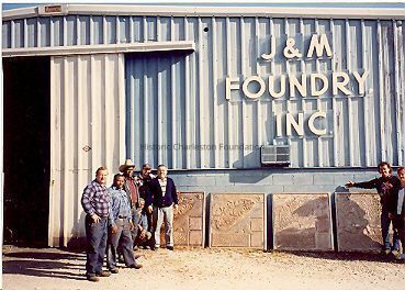
Four bronze historical maps before they leave J&M Foundry (Charleston), where they were cast, to be placed at Waterfront Park.Context
Maps were researched and then designed by the donor/artist.Collection
HCF Image CollectionAcquisition
Accession
2009.021.Source or Donor
Runyon, Donald R.Acquisition Method
GiftCredit Line
Gift of Mr. Donald R. RunyonLexicon
Nomenclature 4.0
Nomenclature Primary Object Term
PhotographNomenclature Sub-Class
Graphic DocumentsNomenclature Class
Documentary ObjectsNomenclature Category
Category 08: Communication ObjectsLOC Thesaurus for Graphic Materials
Historical markers, Maps, FoundriesSearch Terms
Waterfront Park (Charleston, S.C.)Location
Location
Container
PhotoBox 14Shelf
AV MaterialsRoom
Margaretta P. Childs ArchivesBuilding
Missroon HouseCategory
PermanentDate
February 7, 2023Created By
admin@catalogit.appCreate Date
August 20, 2009Updated By
sferguson@historiccharleston.orgUpdate Date
August 7, 2023