Name/Title
Plat, Adgers WharfEntry/Object ID
ADGERS.GEN.002Description
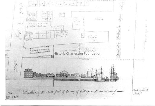
Photographic reprint of a plat showing East Bay Street houses at and just north of Tradd Street. Also features nearby wharves and docks on the Cooper River, including Market Wharf [today South Adger’s Wharf], with a drawing (elevation) of the south front of the row of buildings on Market Wharf. Dated June 1793.Collection
Historic Charleston Foundation Property RecordsLexicon
Nomenclature 4.0
Nomenclature Tertiary Object Term
PlatNomenclature Secondary Object Term
MapNomenclature Primary Object Term
CartographNomenclature Sub-Class
Graphic DocumentsNomenclature Class
Documentary ObjectsNomenclature Category
Category 08: Communication ObjectsLOC Thesaurus for Graphic Materials
PlatsSearch Terms
Streets, South Adger's Wharf, North Adger's Wharf, Tradd Street, Streets--South Carolina--CharlestonLocation
Location
Cabinet
Photo File CabinetsRoom
Margaretta P. Childs ArchivesBuilding
Missroon HouseCategory
PermanentDate
February 7, 2023Location
Building
Missroon Archives/Photo File CabinetsCategory
PermanentRelationships
Related Entries
Notes
ADGERS.010.1, ADGERS.016.1, ADGERS.018.1, ADGERS.GEN.001, ADGERS.GEN.003, ADGERS.GEN.004, ADGERS.GEN.005, ADGERS.GEN.006Related Publications
Notes
Buildings of Charleston, p. 53Provenance
Notes
Charleston County RMC photo.Copyright
Copyright Details
Public domainCreated By
admin@catalogit.appCreate Date
April 1, 2004Updated By
admin@catalogit.appUpdate Date
February 16, 2023