Name/Title
Aerial Views of Charleston PeninsulaEntry/Object ID
2016.003.2a-cDescription
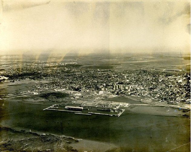
Three B&W aerial views of Charleston:
a: Looking east across the peninsula. Landmarks include the West Point Rice Mill, City Marina, Roper Hospital, Grace Memorial Bridge, and a stadium, possibly the Johnson Hagood Stadium. Likely dated early 1960s.
b: View of the entire peninsula and the Charleston Neck. Landmarks include the southern tip of the peninsula, Cooper River wharves, and the Grace Memorial Bridge; the western edge of the peninsula showing Sgt. Jasper apartment building, Roper Hospital, City Marina, and the grounds of the Citadel; and the industrial areas in the background, above Mount Pleasant Street. Alberta Long Lake has not yet been enclosed. Presumably an HCF area project map related to zoning, as indicated by areas outlined with red and green lines. The furthest red line is likely Mount Pleasant Street. The northern boundary of the featured zoning area is likely Line Street, the northern boundary of the Historic District. Likely dated mid-1950s.
c: Looking north across the peninsula from Broad Street to Mount Pleasant Street and beyond. Landmarks include Colonial Lake, Washington Square Park, Robert Mills Manor, Memminger Auditorium, Memminger School, Roper Hospital, Francis Marion Hotel, Marion Square, Grace Memorial Bridge, and the industrial areas in the Neck. Presumably an HCF area project related to zoning, as indicated by sections outlined in red ("1.5 miles, 17 blocks") and green ("area greater than 1.5 miles, 10-12 blocks"). Likely dated mid-1950s.
Dates of photographs estimated by the status of Lockwood Boulevard and the absence of the Silas N. Pearman Bridge and the Crosstown.Photograph Details
Type of Photograph
Gelatin SilverCollection
HCF Image CollectionAcquisition
Accession
2016.003Source or Donor
New Photos Catalog Records (2016)Acquisition Method
Found in CollectionMade/Created
Artist
Historic Charleston FoundationDate made
circa 1955 - circa 1965Lexicon
Nomenclature 4.0
Nomenclature Primary Object Term
PhotographNomenclature Sub-Class
Graphic DocumentsNomenclature Class
Documentary ObjectsNomenclature Category
Category 08: Communication ObjectsLOC Thesaurus for Graphic Materials
Aerial photographsSearch Terms
AerialViews/Photographs, Charleston (S.C.)--Aerial viewsDimensions
Height
11 inWidth
14 inDimension Notes
Photographs mounted on matte board.Location
Location
Container
Oversize Box 1Shelf
Archives D-7Room
Margaretta P. Childs ArchivesBuilding
Missroon HouseCategory
PermanentDate
February 7, 2023Provenance
Notes
Found in HCF warehouse in 2016.Copyright
Copyright Details
In copyrightCreated By
admin@catalogit.appCreate Date
October 12, 2016Updated By
sferguson@historiccharleston.orgUpdate Date
September 26, 2023