Charleston Scenes, ca. 1920s
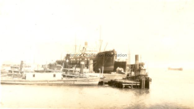
1: Boats in Harbor
Origsize: 2.75X4.5; Origformat: Print-Photographic
Name/Title
Charleston Scenes, ca. 1920sEntry/Object ID
2011.003.04Description
Sixteen photographs, ca. 1920s, presumably removed from a photograph album. Two pages with four photographs affixed to both sides of the page. Photo 1: Tugboat and other ships in a floating dry dock in the Charleston Harbor (possibly Charleston Shipbuilding). Photo 2: View of the Charleston waterfront from the Ashley River. Some of the landmark buildings visible in the background include St. Matthew's Church, Francis Marion Hotel, St. John's Lutheran Church, Unitarian Church, St. Philip's Church, People's Building, St. Michael's Church, and West Point Rice Mill. Photo 3: View of the Charleston waterfront from the Cooper River. Some of the landmark buildings visible in the background include Fort Sumter Hotel, St. Michael's Church, St. Philip's Church, U.S. Custom House, and several wharves. Photo 4: Two cars on the Ashley River Bridge, one heading east and one heading west. View of the Charleston waterfront in the background. Photo 5: Looking northeast, possibly from St. Michael's Church, showing Broad Street and the area to its north bounded by East Bay Street, and possibly Queen Street. Cars are parked along the street. Landmarks include the Confederate Home and its rear dormitory apartments, People's Building, Old Exchange Building, and the corner of Broad and Church Streets showing the Bank of South Carolina Building (50 Broad Street) before it was restored. A faint view of the U.S. Customs House is at the far left. Photo 6: Looking southeast, possibly from the Francis Marion Hotel, with Meeting Street bisecting the view at a diagonal. Landmarks include the U.S. Customs House, Charleston Hotel, People's Building, and St. Philip's Church. Photo 7: Looking south on King Street, possibly from the Francis Marion Hotel, showing King Street from ca. 360 King down to the bend near Market Street, and the view east of King Street. Vehicles can be seen on King Street. Landmarks include the Masonic Temple Building (270 King Street), the tower of the Peoples First National Bank Building (a/k/a Hirsh Israel Building, 275 King Street), and the Hotel Calhoun (238-242 King Street). Photo 8: Looking southwest, possibly from St. Michael's Church, toward James Island. Landmarks include the Fort Sumter House (1 King Street), Col. John Ashe House (32 South Battery), rear of First Scots Presbyterian Church (57 Meeting Street), Miles Brewton House (27 King Street), and the north elevation of the John E. Poyas House (69 Meeting Street). Photo 9: Looking northeast, possibly from City Hall. Landmarks include the rear dormitory apartments of the Confederate Home, St. Philip's Church, and the U.S. Customs House. Photo 10: Looking north on Meeting Street, possibly from St. Michael's Church, and showing the view west of Meeting Street. Vehicles, including a trolley car, can be seen on the street. Landmarks include the Timrod Hotel, Mills House Hotel, Fireproof Building, Circular Church, and Francis Marion Hotel (in the distance). Photo11: Looking east on Calhoun Street, possibly from the Francis Marion Hotel, toward the Cooper River. Landmarks include the Calhoun Monument in Marion Square, Citadel Square Baptist Church, Emanuel A.M.E. Church. Other identified buildings include 316 Meeting and 314 Meeting, and the Zion Presbyterian Church (123 Calhoun). Photo 12: Looking north possibly from St. Michael's Church. Landmarks include St. John's Lutheran Church, Unitarian Church, Grace Episcopal Church, and the Charleston Orphan House (in the distance at right). Photos 13-16: Views of the Sunken Garden in Hampton Park.Collection
HCF Image CollectionAcquisition
Accession
2011.003.Source or Donor
New Photos Catalog Records (2011)Acquisition Method
Found in CollectionMade/Created
Artist
UnattributedDate made
circa 1926Lexicon
Nomenclature 4.0
Nomenclature Primary Object Term
PhotographNomenclature Sub-Class
Graphic DocumentsNomenclature Class
Documentary ObjectsNomenclature Category
Category 08: Communication ObjectsLOC Thesaurus for Graphic Materials
Aerial photographsSearch Terms
Marine scenes, Broad Street, Meeting Street, Calhoun Street, Cars, Waterfronts--South Carolina--Charleston, Charleston Harbor (S.C.), Cooper River (S.C.), Ashley River Bridge (Charleston, S.C.), Boats and boating, Antique and classic cars, Charleston (S.C.)--Aerial views, Hampton Park (Charleston, S.C.), Citadel Square Church (Charleston, S.C.), Streets--South Carolina--Charleston, Parks--South Carolina--CharlestonDimensions
Height
2-3/4 inWidth
4-1/2 inLocation
Location
Container
PhotoBox 15Shelf
AV MaterialsRoom
Margaretta P. Childs ArchivesBuilding
Missroon HouseCategory
PermanentDate
February 7, 2023Provenance
Notes
Found in a box of miscellaneous unidentified photographs.Copyright
Copyright Details
Possibly public domain by 2023.Exhibitions
Notes
Exhibit Start: 2015-11-1617