Name/Title
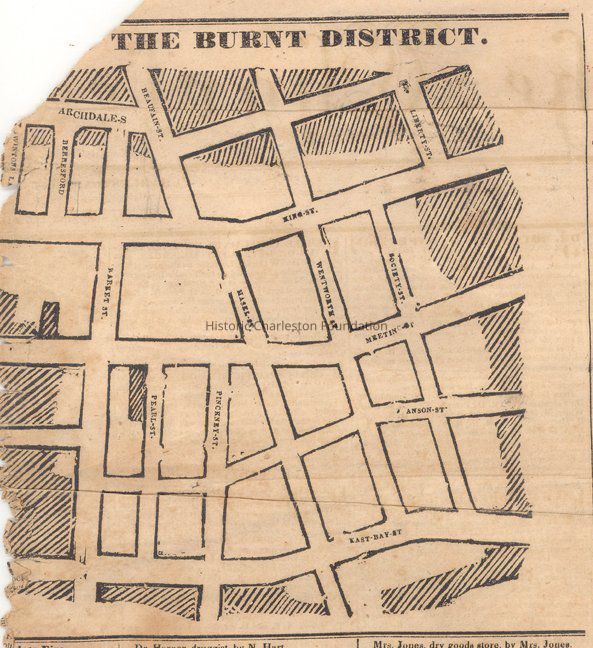
The Burnt District [map] 1838 Ansonborough FireEntry/Object ID
2009.001.7Scope and Content
Charleston Courier article of 1838 showing map of "The Burnt District" (Ansonborough) and list of the homeowners. Large portion of the article; portion of left side missing (torn).Collection
HCF Map CollectionAcquisition
Accession
2009.001.Source or Donor
New Archives Catalog Records (2009)Acquisition Method
Collected by StaffLexicon
Nomenclature 4.0
Nomenclature Secondary Object Term
MapNomenclature Primary Object Term
CartographNomenclature Sub-Class
Graphic DocumentsNomenclature Class
Documentary ObjectsNomenclature Category
Category 08: Communication ObjectsSearch Terms
Historic maps of Charleston, Ansonborough, Fires--South Carolina--Charleston--19th century, Charleston (S.C.)--MapsArchive Details
Creator
Charleston Courier (Charleston, S.C. : Daily), Charleston Courier, Vol. 26, 1838Date(s) of Creation
1838Archive Size/Extent
1 page, approx. 17" x 9"Restrictions
Access: Refer to photocopy (in 2 parts) for research. Original is extremely fragile.Archive Notes
Date(s): 1838Dimensions
Dimension Notes
8.5" x 11"Location
Location
Container
FolderDrawer
Drawer 4Cabinet
Blueprints-Maps 5Room
Margaretta P. Childs ArchivesBuilding
Missroon HouseCategory
PermanentDate
February 7, 2023Condition
Notes
Fragile; damage (torn) from being folded.Relationships
Related Places
Place
City
CharlestonState/Province
South CarolinaCountry
United States of AmericaCreated By
admin@catalogit.appCreate Date
February 23, 2009Updated By
admin@catalogit.appUpdate Date
February 17, 2023