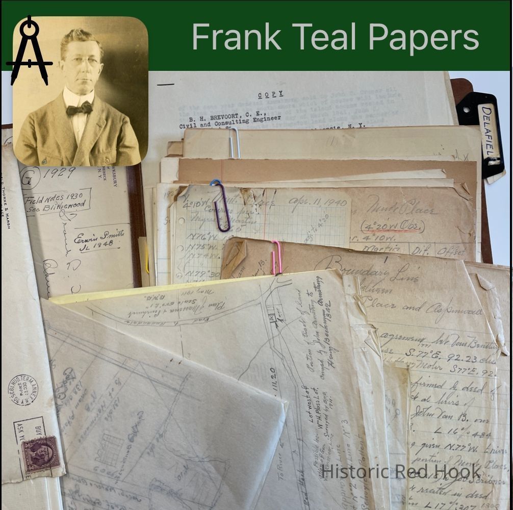
Name/Title
DELAFIELDEntry/Object ID
2016.011.168Scope and Content
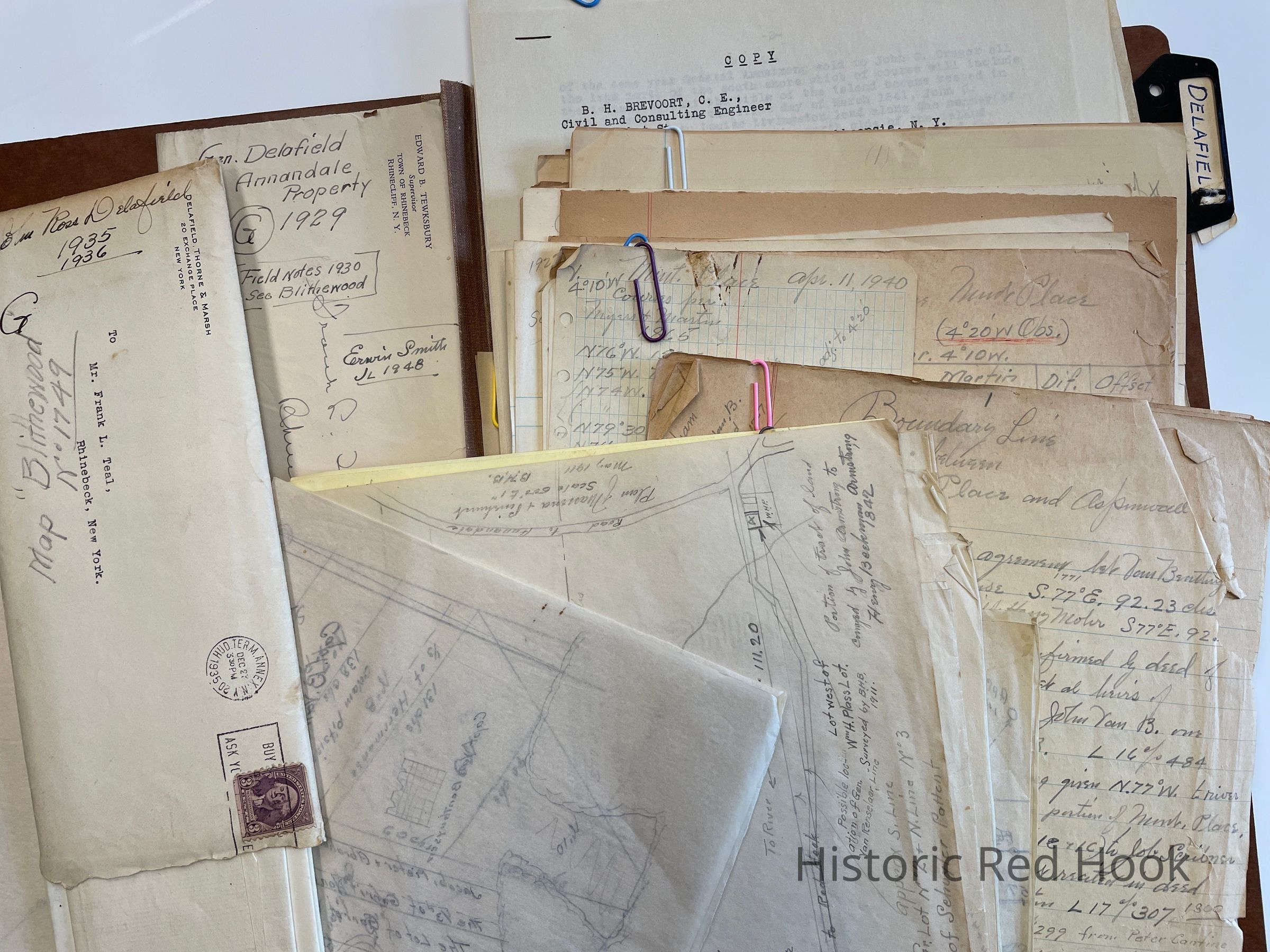
Field Notes: Obie A. Holsapple, Upper Red Hook; Benjamin Pease, Mary Santamarina, George Ljutich
Map: Spurr to Barton 7.80 acres 1918
Letters from JRD to Teal Re: Road from Red Hook to the Sawkill
Maps showing proposed construction of road Rock-City-Rhinebeck Highway 13 Nov 1931
Letters from Richard Aldrich to Frank Teal about new road.
Maps: Zabriskie Section, Chapman section, Delafield Section
Field notes:Blithewood
Survey map for John Aspinwall 22 Aug 1890
Map: Portion of tract of land by John Armstrong to Henry Beekman Armstrong 1842.
Map: Former Lot 4 of Herrmanse Partition:
1B.Moore to Maj. Jackson 1788 L11:34
2&3 Hendrick Herrmanse to Philip Henry Moore 1771
1A Herrmanse to Livingston 1773; Robert Gilbert Livingston to Maj. Jackson 1784;Homestead of John R. Livingston Esq. 1796 L14:299
Map from John Blyker of Albany 1745:
No1. Capt B. VanBenthuysen
No. 2. 1. Heermanse
2. Pieter, Jacob, Abraham Van. Benthuysen, 1/3 of Andries Herrmanse
3. “ ” “
4.Garrit Van Benthuysen
5.Jacob, Pieter, Abraham V. Benthuysen & the 1/3 of Garrit V. Benthuysen
No. 3 Col. Beekman
No. 4 Col. Beekman
No. 5 Capt. VanBenthuysen
No. 6
No. 7 Piet Pitsier
No. 8 Adam Pitsier & 1/3 Herrmanse
No. 9&10 No names
Envelope with map of Blithewood
Letters from JRD to Frank Teal 1946
Survey: Parcel conveyed to Garrett B. Kip 24 Nov 1911 372:35, being Aspinwall property west of the highway 255 acres and 23.5 acres under water. Being included:
1.Stewart Brown & wife to John L. Aspinwall 2 Jul 1860 & 28 Dec 1860
2.William R. Moore & wife to Aspinwall 1 Apr 1865 130:515
Letters from John Ross Delafield to Frank Teal
Survey of boundry line between Montgomery Place and Aspinwall.
Zera B. Patterson to Frank H. Trow and Sadie L. Trow 24 Sep 1919 407:265: Being a portion of tract of which William L. Chamberlain died seized and designated as “C” on “Outline Map” 221 acres. Being same conveyed by John N. Lewis and Nelson P. Lewis Exec. Of Christina J. Lewis to Zera D. Patterson 1 Apr 1911 369:508
Frank Waller to Andrew C. Zabriskie 1899 303:119: Being part of farm conveyed to Chas. E. Sands by Robert Adams 14 Nov 1859 114:599, being Lot No. 2 35 Acres ALSO parcel from Adams to Seymour in 1859 ALSO Lot late owned by trustees of S.S.C. 5
acres. Same as to Letitia Campbell Sands by trustees 1864 being three of the parcels from Frederick VanVleck Ref. To Frank Waller 1898
Arthur C. Waller to Andrew Zabriskie 1912 373:383 1st parcel 17.631 acres
2nd parcel 1.10 acres
Also Mill property 5..2..28
Letters from John Ross Delafield to Frank Teal 1930-1931
Map of junction of Staats & Zabriskie lines at Dam. 1931
Map 8 acre lot
Map: Zabriskie, adjustment at S end of Mill dam
Survey for Eliwyn H. Spear to Stephen A. Tator & Nellie his wife 23 Jun 1943 L609:3
Conveys property in Village of Cedar Hill. Parcel 1 1/4 acre; Parcel 2: Lot Parcel 3: 0.57 acre Same as conveyed to Spear from John B. Hoppe, Ref 26 Mar 1943
Survey from easterly portion of land of William McMichael in Annandale. 0.30 acre
For William L. Wildey 5 Jan 1921
Wm. C. Wakeman to Henry Rifenburgh 17 Nov 1877 L189:517 Being same as John C. Cruger in 1856 to David Fearyer & devised in will to Henrietta Fearyer
Christina Staats to Henry Rifenbugh 3 Oct 1883 L 215:526 1/4 acre
Ellen Rifenburgh & Others to Nellie G., Simmons 10 Apr 1895 L 283:272
Eli Plass & Mary J. Plass to William H. Simmons 14 Feb 1902 L 318:72
Survey of parcel conveyed by Thomas E. Thompson in 1918 to Carrie Thompson in Annandale 4.97 acres
Survey for Delafield of parcel 1.039 acres, formerly property of John E. Plass, now Carrie E. Thompson & heirs of William S. Smith
Traced map of Capt. VanBenthuysen’s land, made by John Blyker of Albany in 1745.
Abstract of Title of Garrett B. Kip & Carole dePeyster Kip (Now St. Joseph’s Normal Institute)
25 Aug 1928 Main parcel 255.576 Acres & 23.5 acres underwater Also house and lot
Parcel 1. Homestead Farm of John R. Livingston Esq. As owned and occupied by him from the beginning to the middle of the last century.
Parcel 2&3: Portion of farm owned by Moore Family during same period.
Parcel 4: Being a house & lot on south side of road to Upper Landing, was a portion of tract of land owned by John Armstrong and conveyed by him to his son Henry B. Armstrong 22 Dec 1842 L74:502
Henry B. Armstrong to Peter Barringer 1 May 1845 L80:402 Same as above
Robert Barringer & wife Nancy to William Stringer 1858 L348 “
William Stringer & Ann to John L. Aspinwall 9 Mar 1864 126:202 Same as above
Garrett B. Kipp & wife conveyed this lot to Margaret Aldrich in 1912
Reservoir Spring and Pipe rights 4 acres 1866
Water grant 1873 to John, Helen and Emily Aspinwall
Lease: Executors & heirs of John L. Aspinwall to John Aspinwall, leases “Pinehurst”
Jane M. Aspinwall, Exec. To Peter W. Funk 1890 L256:225; Funk to Patrick Quinn 1891 L260:177; Quinn to Aspinwall 1911 L367:441
Garrett B. Kipp & wife to St. Joseph’s Inst.
List of Aspinwall Heirs: John Aspinwall & Helen Aspinwall Redfield, formerly Helen Lloyd Shober and formerly Helen Lloyd Aspinwall, Juliet Aspinwall.
John R. Livingston to Hudson River Railroad 31 Aug 1850 L92:491
Early History of tract of “Massena” and” Pinehurst” From Original Patent of Schuyler.Collection
Teal-Decker CollectionRelationships
Related Person or Organization
Person or Organization
Teal, Frank L.Related Places
Place
Property
Blithewood Manor, Bard College CampusHamlet
Annandale-on-HudsonTown
Red Hook