Name/Title
HOLT, CLAYTON RED HOOK -Holt Rd.Entry/Object ID
2016.011.220Scope and Content
Survey: For Clayton Holt 16 Aug 1963 0.381 acre
Survey: For Clayton Holt Nov 1963 0.884 acre. Taken from land from William Metzger & Willie Metzger to Clayton & Ruth Holt 29 June 1945 627:298
Survey: For Clayton Holt Oct 1964 60.0 Sq. Feet. “Well Parcel” Taken from area around a well on the Tratnack parcel of said Holt & included in a parcel from Holt to Rolland F. Coon & wife Helen M. Coon.
Survey: For Clayton Holt 16 Aug 1963 0.380 acre
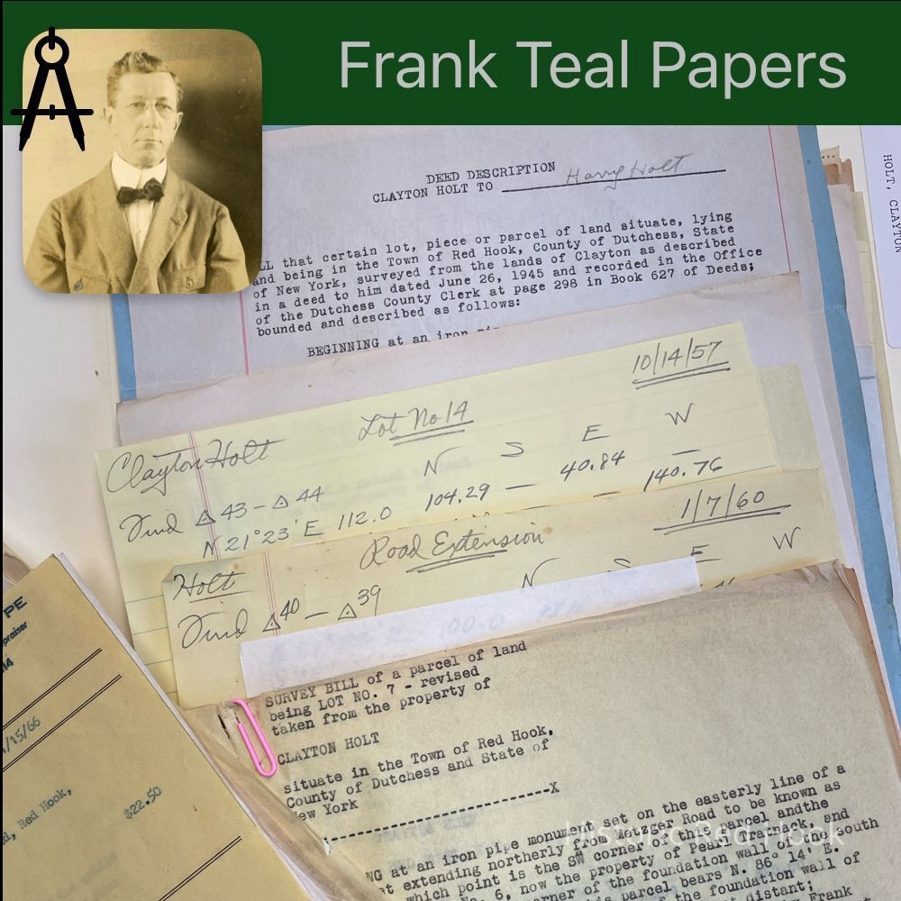
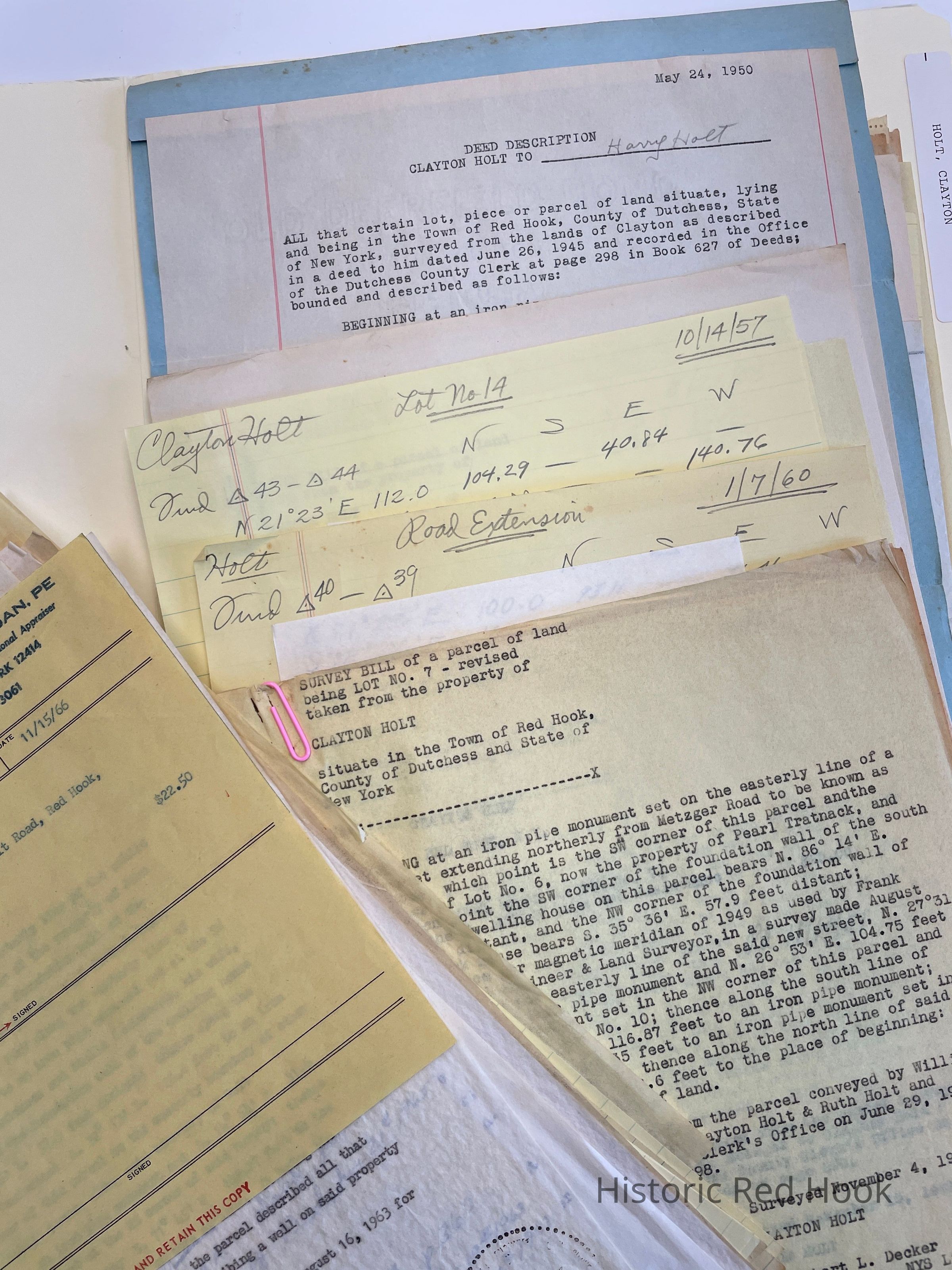
Survey: For Clayton Holt June 1956 0.106 acre. Originally intended as a ROW
Field Notes: June 1945 From Frank Teal for Clayton Holt
Survey: 14 June 1945 For Clayton Holt. From parcel taken from land of William A. Metzger. 19.53 acres. Mentions Farm formerly of James Baxter, now Mary Norton, along North line of land leased by Gen/ John Armstrong to Skey Van Keurern in 1801.
Deed: 27 Mar 1906 347:1121 Adam Metzger to Wm. A. Metzger 268 acres. Being larger part of two deeds to Frederick More from Frederick E. Radcliff in 1852 96:240 and deed by John More & wife Elizabeth in 1858 111:103. 2nd- Abraham Pardee 1884 218:32 7 acres 10 perches per deed Benedict to Pardee. “This deed describes the north 1/3 part of Schuyler Vly retained by Armstrong 1899.
Survey: Dec 1955 for Clayton Holt. Lot #12 0.334 acres
Survey: 4 Nov 1953 For Clayton Holt: 0.353 acre Being Lot #7
Survey: Oct 1957 For Clayton Holt Lot #14 0.359 acre
Survey: Jan 1958 For Clayton Holt Exterior boundries a parcel of land for the Clayton Holt lighting district comprising the properties abutting Holt Road
Survey: July 1959 For Marvin P. Jornov & Betty J. Jornov 0.370 acre.North portion of rear lot in division of land from Karl G. Munz & wife Lillian to Jornov
Survey: July 1959 For Marvin and Betty Jornov. 0.533 acre South portion of rear lot as above.
Survey: July 1957 For Marvin & Betty Jornov 0.903 acre Taken from North and East portion of above “Rear Lot”
Survey: July 1957 For Franklin & Gloria D. Jornov & Marvin & Betty Jornov. Front Lot 0.74 acre Taken from southerly portion of land of Karl Munz
Map: July 1957. Shows division of property of Franlin Jornov et al.
Survey: Oct 1956 For Clayton Holt 0.402 acre Lot # 13
Survey: 22 Aug 1955 For Clayton Holt Lot # 11 0.38 Acre
Survey: Oct 1956 For Clayton Holt 0.80 acre “Harry Holt Lot”
Deed: Clayton Holt to Harry Holt 0.37 acre May 22 1950
Map: 23 May 1950 3 divisons of lands of Clayton Holt
Survey: Oct 1956 For Clayton Holt. Extension of Holt Rd.
Survey: Jan 1953 for Clayton Holt “Proposed Town Road Lot 0.262 acre
Survey: 4 Nov 1953 For Clayton Holt Lot # 10 0.368 acre
Surveys & Maps: 22 Aug 1949 For Clayton Holt. “The House Lot” 0.496 acre. “The West Lot” 1.72 acres.
Survey: 11 Aug 1952 For Clayton Holt Lot #5 0.402 acre
Map: 5 Acre Woodlot. Nicholas Bonesteel 1801 18-3-5; Samuel Ten Broeck, wood lot; Now A.F. Drury or George Drury except 5 acres on east end.
Survey: 11 Aug 1952 For Clayton Holt Lot #5 0.402 acre
Survey: 19 Jan 1953 for Clayton Holt Lot # 9 0.45 acre Revised in May 1953 0.85 acre.l
Survey: 19 Jan 1953 For C. Holt Lot # 8 0.50 acre
Map: Plan 19.53 acresCollection
Teal-Decker CollectionRelationships
Related Person or Organization
Person or Organization
Teal, Frank L., Holt, Clayton