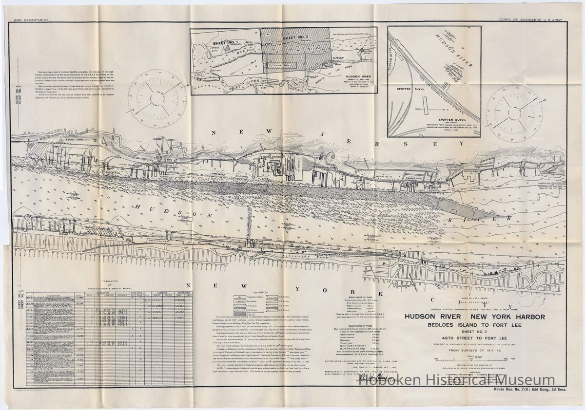
Map: Hudson River, New York Harbor; Bedloes Island to Fort Lee. Sheet 2 of 2. From surveys of 1911-12; issued March 4, 1912.
Entry/Object ID
2012.001.0061
Scope and Content
Map: Hudson River, New York Harbor; Bedloes Island to Fort Lee. Sheet 2 of 2. Surveyed in compliance with River and Harbor Act of June 25, 1910; from surveys of 1911-12. Issued by U.S. Army Corps of Engineers, March 4, 1912. House Document, No. 719 ; 62nd Congress., Second Session [Dec. 4, 1911 to Aug. 26, 1912.]
(see notes for other text)
Sheet 2 covers Weehawken north to Fort Lee.
PDF on file with full sheet and sectional views. Hoboken is not on this sheet, but is on sheet 1. See archives 2012.001.0060 for sheet 1 of 2.
Map as received was previously removed from government document. Sheet size: 22" high x 32 wide; folded to 5" x 9" high.
Acquisition
Accession
2012.001
Source or Donor
Purchase
Acquisition Method
Purchase
Credit Line
Museum Collections.
Archive Details
Date(s) of Creation
1911 - 1912
Archive Notes
Date(s) Created: 1912
Date(s): 1911-1912
Date Published: 1912
General Notes
Note
Notes: sheet no. 2 of 2 sheets
WAR DEPARTMENT
UNITED STATES ENGINEER OFFICE, DISTRICT NO. 1. NEW YORK.
HUDSON RIVER NEW YORK HARBOR
BEDLOES ISLAND TO FORT LEE
SHEET NO. 1 BEDLOES ISLAND TO 48TH STREET
SURVEYED IN COMPLIANCE WITH RIVER AND HARBOR ACT OF JUNE 25, 1910.
FROM SURVEYS OF 1911 - 12
Scale: 1:12,500
PREPARED UNDER THE DIRECTION OF COLONEL W. M. BLACK. CORPS OF ENGINEERS U.S. ARMY.
assistants
j.h.rostock, prin asst.engr
a.p.morris, chief draftsman
c h.gardner, jun engr in charge of surveys
drafting by
h. r. glutzbeck, jun engr
g. l. reeder, surveyor
field work by
g. l. reeder, surveyor
UNITED STATES ENGINEER OFFICE. DISTRICT No. 1, NEW YORK ROOM 702 ARMY BUILDING
NEW YORK. N. Y.,....... MARCH 4, 1912
RESPECTFULLY FORWARDED TO THF CHIEF OF ENGINEERS WITH REPORT OF THIS DATE,
PREPARED UNDER THE DIRECTION OF
COLONEL W M BLACK. CORPS OF ENGINEERS U.S. ARMY.
House Doc, No. 719 ; 62d Cong., 2d Sess.
Status: OK
Status By: dw
Status Date: 2012-06-19