Name/Title
MAP OF PASADENA, ALTADENA, GLENDALE, EAGLE ROCK, ALHAMBRAEntry/Object ID
98.7.1.1Description
MAP OF PASADENA, ALTADENA, GLENDALE, EAGLE ROCK, ALHAMBRA
Color: Black and white
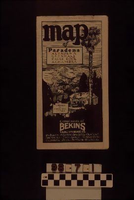
"Map of Pasadena, Altadena, Glendale, Eagle Rock, Alhambra", issued by Bekins Van & Storage Co., ca. 1925. The map has a front panel with the title at top left; drawing of homes, mountains, and a palm tree and other landscaping at center; and the company name and California offices at the bottom. When the map is unfolded, one side has a half-sheet of photographs and information on Bekins with a map of California locations. The other half-sheet on this side is an alphabetical street listing for the map. The reverse side is the map with the title at top right, including local offices of Bekins and at bottom left is an image of a company truck at a house with California locations listed. Stamped at the top of the front panel is 140 NO. BRAND BLVD. / GLENDALE DOUG 6571." With some tears along the folds and the upper and lower edges; creases on the edges (aside from the folds); and discoloration, the object is in good condition.Lexicon
LOC Thesaurus for Graphic Materials
MapsSearch Terms
Three-dimensional, Maps, Bekins Van & Storage Co., Road maps