Name/Title
JLS Coombs family, nautical charts and coastal surveysEntry/Object ID
2019.006.010Scope and Content
Fifty-three rolled charts and surveys, some with fabric backing, some originally rolled together. The forty-eight charts date from the mid nineteenth century and most belonged to J. L. S. Coombs; two are identified as belonging to G. A. Coombs (brother to J. L. S.). The coastal surveys are modern (1973): four cover the Penobscot Bay region, one the river region near Plantersville, S.C.
Individual descriptions below; thumbnail images attached in the additional media section.
Nineteenth-century charts:
1. West Indies, Sheet 3, St. Domingo to Dominica (surveyed 1857), published in London by the Admiralty (1858), 39 1/2" w x 26 3/4" h. Overall good shape, paper bound in blue cloth ribbon, no backing. Some binding missing or loose.
2. Portugal and Spain, Chart 78, Cape San Vincente to Gibraltar Strait, published by James Imray and Son (1881), 42 1/2" w x 28 3/4 h. Overall good shape, paper, blue backing.
Penciled notations:
"June 7, 1882, BK Surprise from N York for Cadiz"
"Pass by [?] of Sight"
3. Chesapeake Bay, with the James, York, Rappahannok, and Potomac Rivers, Eldridge's Chart 7 (1882), 33 1/2" x 58". Overall good shape, paper with cloth backing. Some discoloration at edges.
4. Eldridge's New Chart of Boston Harbor (1868), 27" w x 20" h. Paper, no backing, discoloration at edges and on verso, tear on left edge.
Penciled name on left side of chart:
"J. L. S. Coombs, ___ Islesboro"
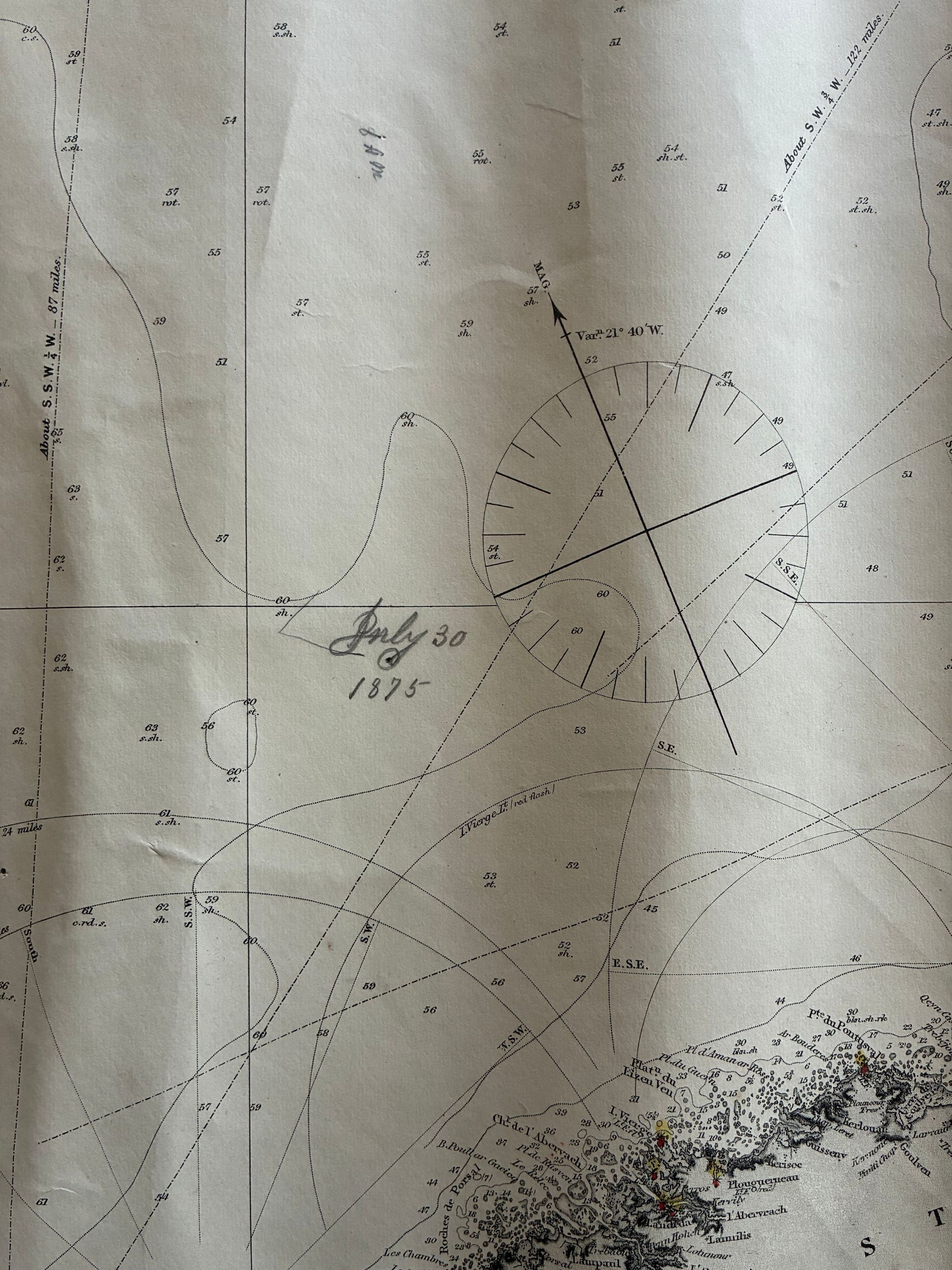
5. Bay of Biscay with Plans of Harbours, published by James Imray and Son (1875), 41" w x 49 1/2" h. Paper, blue backing, ribbon binding, stitched. Mostly good condition, one tear near the top, below wooden hanging rail.
6. Mount Desert Island Frenchman's and Blue Hill Bays and Approaches, U.S. Geologic Survey (1883), 30" w x 39 1/2" h. Paper, cloth backing, worn, much creasing.
7. West Coast of Ireland, compiled from Admiralty Surveys (1862), 28 1/4" w x 50 1/2" h. Paper, no backing, good condition, intact ribbon binding.
8. Vineyard Sound and Nantucket Shoals, S. Thaxter and Son (1862), 62 3/4 w x 41" h. Paper, cloth backing, poor condition. Map creased and discolored, backing loose. The name G. A. Coombs is marked on the back.
9. South Coast of the United States: Cape Lookout to Cape Canaveral, Sheet 2 from U.S. Coast Surveys, E. and G. W. Blunt (1860), 32" w x 48" h. Very poor condition, creased and discolored, cloth backing tattered and loose, Penciled navigational markings. The map was found rolled up with map 8--also G. A. Coombs?
10. English Channel, James Imray and Sons (1872), 74" w x 41 1/4" h. Good shape, despite some creases, backing and stitched ribbon binding intact. Penciled locations for Feb[?] 13, 1875, and July 30, 1875.
11. Coast Chart No. 157, from Sapelo Island, Georgia, to Amelia Island, Florida, U.S. Coast and Geologic Survey (issued 1877), 36" w x 44" h. Paper in good condition, no backing, some discoloring and crumpling on right side. On verso is written "Chart of Brunswick, Ga, JLS Coombs."
12. Chesapeake Bay, with the James, York, Rappahannok, and Potomac Rivers, Eldridge's Chart 7 (1871), (Map 3 of same area, 1882), 32 3/4" w x 56 1/2" h. Cloth backed paper, some discoloration front and back, small tears at edges, creasing and large tear bottom left.
13. West Indies, Windward Lesser Antilles, Martinique (1824-25), 29 3/4" w x 44" h. Paper discolored and torn, backing loose, evidence of mold.
14. Bay and Harbor of New York (1874), 41" w x 54" h. Paper, no backing, frayed edges, torn upper right corner.
15. Narragansette Bay, from Trigonometical Survey of the Coast of the United States (1873), 32" w x 44 1/2" h. Reasonable shape, no tears, although backing has some mold. "Newport & Providence" is penciled on one end of the rolled map, at the other end "R. Island."
16. West Indies, Providence Channels to Windward Mona Passage, [and] North Coast of Haiti, surveyed by Capt. R. Owen and E. Barnett, R.N. (1831-43); main map 41 1/2" w x 26" h, outset map 15 3/4" w x 7 1'4" h. Oddly shaped paper chart, rectangular with outset of the northern Haitian coast, loose blue cloth binding, crumpled edges, penciled navigational marks through the Windward Passage and along the Haitian coast.
17. Coast Chart No. 4, Penobscot Bay, Maine, United States Coastal and Geodetic Survey (1880), 32" w x 42 1/2" h. Paper map, tearing at edges, one significant tear on right side.
18. Penobscot River and Belfast Bay, United States Coastal and Geodetic Survey (1882). Paper map, reasonable shape.
19. Chart of the St. George's Channel and Irish Coast drawn from late surveys of the Lords Commissioner of the Admiralty, published by James Imray and Son, London (1853), 32 1/2 w x 55" h. Paper map, blue backing, white cloth binding, very wrinkled, some mold, large wrinkled crease at along the top side. Stamp on left side of the map: 'H. C. Riggs, Chronometer, Nautical Store, 126 South Front Street, Philadelphia."
20. The North Sea, compiled from the most recent surveys, J. A. Imray and Son, London (1871), 55" w x 40" h. Large map, blue backing, some tearing, right side has large mold spot, mending on the back side near the mold.
21. Cuba and the Windward Passages, E. and G. W. Blunt, New York (1863), 41 1/2" w x 78 1/2" h. Large map in poor condition, mold, tears, ripped and repaired, backing of patterned fabric falling off. Information from other piloting books pasted on, penciled navigational notation reads "1882, Nov 25 at [noon?]."
22. Chart of the Vineyard Sound and Nantucket Shoals, surveyed by George Eldridge, hydrographer, published by S. T. Thaxter & Son, Boston (1862), 64" w x 42" h. Very large map, blue backing, hand-stitched binding, joined sections in thirds, joins lifting, some discoloration, mending tape on back.
23. Chesapeake Bay, Sheet No. 1, from the Head of the Bay to the Magothey River, Survey of the Coast of the United States published in 18__ [full year not printed]., 42 1/2" w x 33" h. Paper map, no backing, no binding, badly torn, some mold.
24. General Chart of the Coast from Gay Head to Cape Henlopen [Long Island Sound], Survey of the Coast of the United States, published in 1852, 41 1/2" w x 35" h. No backing, no binding, very torn at edges, quite wrinkled.
25. Chart 25, Penobscot Bay to Kennebec Entrance, Survey of the Coast of the United States published in 1873 (reissued 1877, Aides to Navigation corrected to 1878), 35" w x 42 1/2" h. Heavy paper chart, torn at edges, mold discoloration. Name of chart penciled on the back.
26. Atlantic Coast, Cape Sable to Cape Hatteras, United States Coast and Geodetic Survey (1877, issued February 1881), 38" w x 48 1/2"h. Heavy paper, no backing, no binding, edges torn, some discoloration, insets for major ports and bays, penciled navigational marks all down the coast. Name on back reads "From Cape Sable to Cape Lookout," likely because two charts were rolled together.
27. The Adriatic Sea compiled from the most recent surveys, made by order of the British, French, and Austrian Governments, James Imray & Son, London (1871), 41" w x 50 1/4" h. Large chart, with inserts of key ports, large tear at the bottom, no backing [check this], no binding, discoloration along the tear. Penciled navigational notations.
28. Massachusetts Bay from the U.S. Coast Survey, E. and G.W. Blunt, New York (1859), 47" w x 58 3/4" h. Blue backing, white cloth binding, several long tears and a hole, mending tape and mold on the back. Piloting information pasted on the chart from another navigational publication dated 1860.
29. Coast of the United States from Buzzards Bay to Cape Lookout, Hydrographic Office, U.S. Navy (1884), 34" w x 49" h. Water stained, wrinkled, no backing, no binding. Penciled navigational markings and soundings.
30. Eldridge's Chart from Cape Cod to Belle Isle, including the Bay of Funny, Gulf of St. Lawrence, and Banks of Newfoundland, published by E. W. Carpenter (1864), 64 1/2 w x 41" h. Large chart in very poor shape, moldy back, glued in three sections, parting at the section joins and lifting off the blue backing, large tears.
31. Coast of North America between the Strait of Belle Island and Cape Cod, compiled from the most recent surveys, James Imray and Son, London (1862), 75" w x 40 1/2" h. Large tear in the St. Lawrence River, tear on a fold goes all the way through the blue backing, gray cloth binding intact, discoloration from mold, mending tape on the back.
32. Potomac River (in four sheets), Survey of the Coast of the United States (1862), approximately 88" w x 28" h. Sheets 1-3 glued together to create a very long chart, some tearing along the edges, deep fold lines, no backing, no binding, glued seams are lifting, some discoloration, chart name penciled on the back, mold spots. Sheet 1 covers from the entrance to Piney Point; Sheet 2, from Piney Point to Lower Cedar Point; Sheet 3, from Lower Cedar Point to Indian Head. A small, separately rolled chart--presumably Sheet 4--is too fragile to open.
33. East Coast of North America from U.S. Coast Survey and most recent authorities, Sheet IV, Hydrographic Office, U.S. Navy (1870), 32 1/2" w x 48 1/4" h. Intact paper chart, white cloth backing, no binding, wrinkling at top and bottom, some discoloration. Penciled navigational markings along the coast, which covers south to north from below Point Lookout up to Newport.
34. Charleston Harbor and Its Approaches, Survey of the Coast of the United States (1870), 35 7/8" w x 34" h. Heavy paper chart, no backing, no binding, good shape. Chart name penciled on back.
35. Delaware Entrance, United States Coast and Geodetic Survey (1880), 41 3/4" w x 30" h. Includes sailing directions, dangers, tides, buoys, soundings, lighthouses, currents. No backing, no binding, discoloration, evidence of mold, tearing at edges. Penciled on back "Charts for Delaware River / Delaware Bay," likely from having been rolled together with charts 36 and 37.
36. Delaware Bay and River, United States Coast and Geodetic Survey (1848), 41 3/4" w x 20 1/2" h. No backing, no binding, staining, evidence of mold, very torn right edge.
37. Delaware River, with inset of part of the Delaware River from Frankford to Trenton, U.S. Coast & Geodetic Survey (1881), 36 3/4" w x 30 1/2" h. Intact paper, no backing, no binding, fairly clean overall, though staining at top edge.
38. Windward Islands and Spanish Main, E. and G. W. Blunt, New York (1860), 45 1/2" w x 50 1/2" h. Large chart, blue backing white, stitched cloth binding, mending tape on the back; large holes, large rip down the middle, very discolored, evidence of mold, penciled navigational markings.
39. Mediterranean Sea, Western Portion, including Islands of Corsica and Sardinia and Gulf of Venice, published by Charles Wilson (1871), 61 1/2" w x 49 3/4" h. Very large map, inserts of major ports, floral fabric backing, cloth binding, very wrinkled, small holes, staining. Penciled navigational markings.
40. The Great Bahama Bank, Sheet 2, from 24° N. Latitude to Old Bahama Channel, surveyed by Commanders R. Owen, E. Barnet, and T. Smith in HMS Thunder and Lark, 1836-1843, coast of Cuba from the Spanish charts, Hydrographic Office of the Admiralty (Sept. 11, 1850, corrected to 1855, [issued?] Feb. 1863), 39 3/4" w x 27" h. No backing, cloth binding torn, paper fairly clean but some wrinkling, penciled navigational markings through the channel, chart name penciled on back.
41. Ports in the Gulf of Venice, republished from the British Admiralty Chart of 1872 with additions to 1873, published Feb. 1873 at the Hydrographic Office, Washington, D.C., 28" w x 40 1/4" h. Paper very badly torn, frayed bottom edge, discoloration, staining, evidence of mold. Penciled on the back: Brioni Islands.
42. East Coast of North America, Sheet V, Hydrographic Office, U.S. Navy (1870), 34 1/4 " w x 49" h. Paper in good shape, some crumping on edges, quite clean. Penciled navigational markings all along the coast of Florida to North Carolina. On the back: "Hatteras to Florida, Coombs."
43. Atlantic Coast of the United States, Cape Hatteras to Cape Canaveral, Hydrographic Office, U.S. Navy (1884), 34" w x 49 1/4" h. Intact paper, some wrinkling and discoloration, mold, extensive navigational markings.
44. Penobscot River and Belfast Bay, Maine, Continuing to Bangor (inset), U.S. Coast & Geodetic Survey, printed Oct. 22, 1890 (date stamped at bottom edge), 30 1/8" w x 41 1/8" h. Paper intact, crumpled edges, evidence of mold and insects (wiped off weblike material), some wrinkling.
45. Penobscot Bay, Maine, United States Coast Survey (1876), 26 1/2 " w x 41 1/4" h. Paper intact, no binding, cloth backing, some wrinkling, stains, discoloration, especially on the top edge. Written on back "Belfast Bay, Maine, J. L. S. Coombs.
46. East Penobscot Bay, United States Coast and Geodetic Survey, date of first publication 1882, 30 1/4" w x 41 7/8" h. Paper quite stained, discolored, crumpled edges, evidence of mold, insects (weblike material wiped off).
47. The Irish Channel, surveyed 1847, published by the Admiralty, December 31, 1859, 27 1/2" w x 50"h. Long paper chart, in three sections, the top and bottom sections smaller than and separating from the middle section because the glue has dried out; some staining, but main portion is in decent shape.
48. Entrances to the Cape Fear River, North Carolina.Survey of the Coast of the United States, Coast Survey Office (1866), 29" w x 36" h. Paper intact, despite deep fold lines, some tearing, staining, and discoloration at edges.
Twentieth-century coastal surveys
49. Islesboro, Maine, SW/4 15' Quadrangle, Dept. of the Interior, U.S. Geological Survey (1973), 22" w x 27" h. Modern map, in color, good shape.
50. Castine, Maine, NE/4 15' Quadrangle, Dept. of the Interior, U.S. Geological Survey (1973), 22" w x 27" h. Modern survey map, in color, good shape.
51. Searsport, NW/4, Castine 15' Quadrangle, Dept. of the Interior, U.S. Geological Survey (1973), 22" w x 27" h. Modern survey map, in color, good shape.
52. Cape Rosier, Maine, SE/4 Castine 15' Quadrangle, Dept. of the Interior, U.S. Geological Survey (1973), 22" w x 27" h. Modern survey map, in color, good shape.
53. Plantersville, S.C, N330-W7907.5/7.5, Dept. of the Interior, U.S. Geological Survey (1943; photo revised 1973), 22" w x 27" h. Modern survey map, in color, good shape.