Name/Title
Kahoolawe/Makawao DistrictEntry/Object ID
2011.019.52Scope and Content
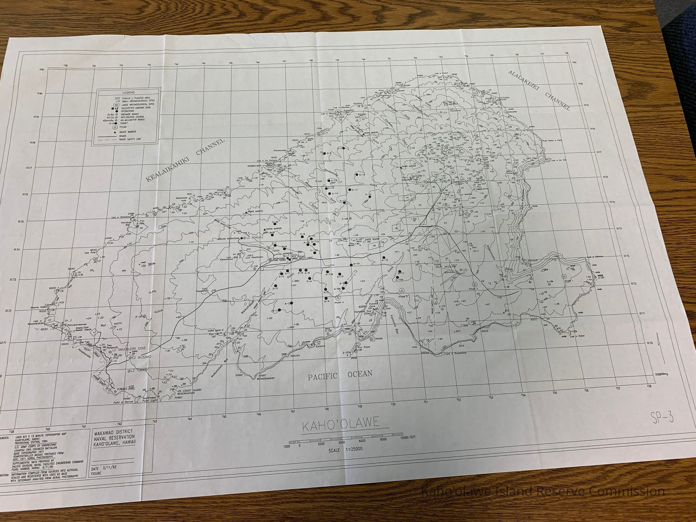
Map of Kahoolawe, Makawao District, Naval Reservation. Shows archaeological sites, gun ranges, planting areas, operation areas, roads, targets. Sources: USGS 8.5 x 15 Minute Topographic Map, Kahoolawe, Hawaii, Provisional Edition, 1984; U.S. Army Corps of Engineering, USARPAC 29th Engineer Battalion; Base Topographic 1971 Semicontrolled Mosaic Prepared from Nov. 1971 Aerial Photography; Supplemental Data Provided by Pacific Division, Naval Facilities Engineering Command, Pearl Harbor, Hawaii 9/11/80.
Preparation: Information compiled from sources into Autocad, scaled and registered with USGS as base with secondary analysis from aerial photography.Collection
KIRC AdministrationCataloged By
Gavagan,TerriLexicon
Nomenclature 4.0
Nomenclature Secondary Object Term
MapNomenclature Primary Object Term
CartographNomenclature Sub-Class
Graphic DocumentsNomenclature Class
Documentary ObjectsNomenclature Category
Category 08: Communication ObjectsLOC Thesaurus for Graphic Materials
Administrative agencies, Archaeological sites, Maps, RoadsSearch Terms
Administrative Records, Archaeology, Cultural Resources, Cultural structures, Maps, Military, administrative records, Archaeological sites, Cultural Resources, cultural sites, infrastructure, maps, military, operations, restoration, roads, UXO Clearance Project, Cultural resources, Cultural sitesArchive Items Details
Title
Kahoolawe/Makawao DistrictDescription
Map of Kahoolawe, Makawao District, Naval Reservation. Shows archaeological sites, gun ranges, planting areas, operation areas, roads, targets.Date(s) of Creation
Mar 11, 1992Subjects
Maps, Archaeological sites, RoadsNotes
Location: Storeroom
Container: Archive Map Drawer 1Relationships
Related Places
Place
Ahupua'a
Kaho'olaweMoku
Honua'ulaMokupuni
Maui MokupuniState/Province
Hawai'iCountry
United States of America