Name/Title
MapEntry/Object ID
0110.1.42Description
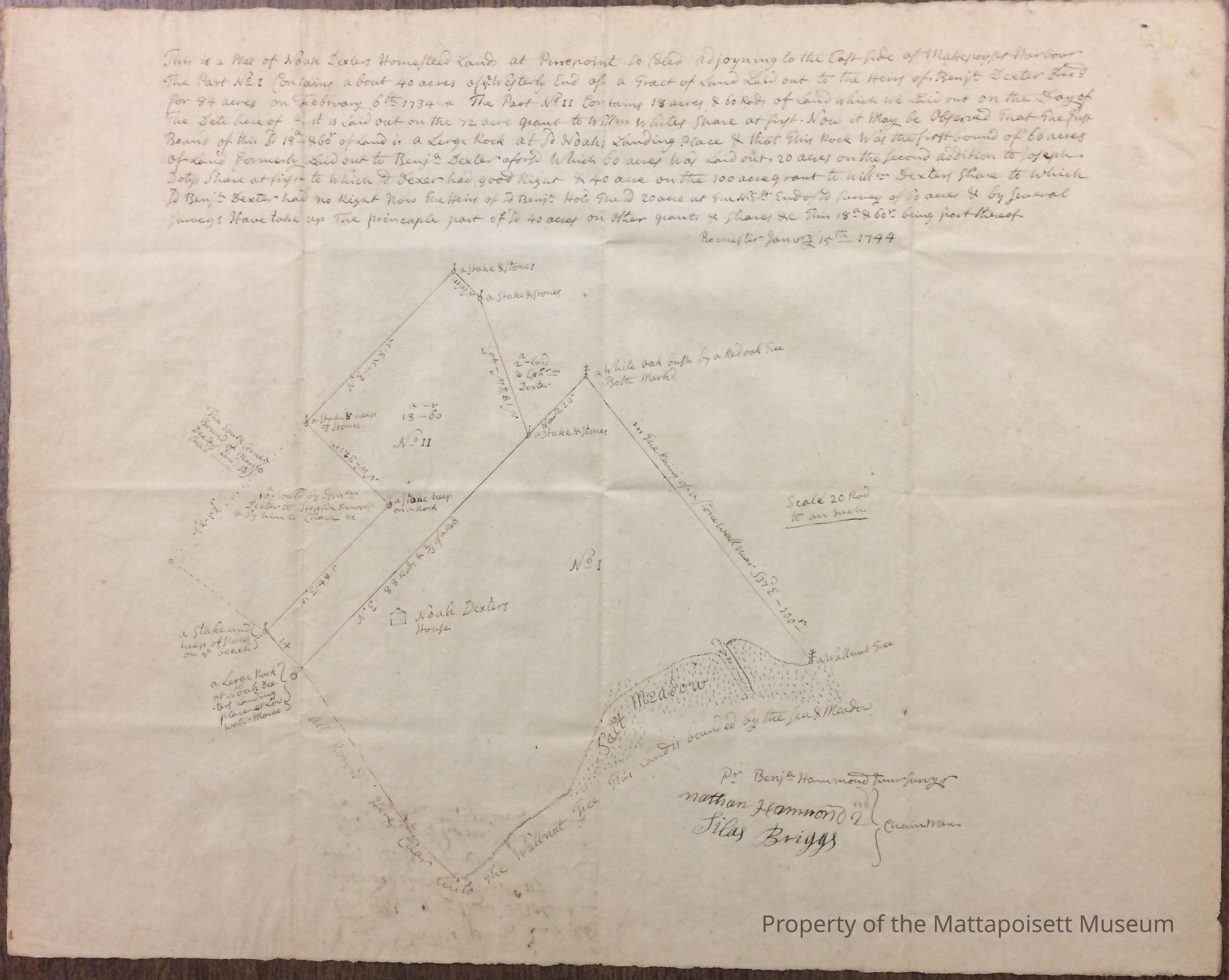
A plan of Noah Dexter's lot at "Pinepoint" on the east side of Mattapoisett harbor, dated 1744.
Transcription of text as follows:
This is a Plot of Noah Dexters Homesteed Lands at Pinepoint So Caled adjoyning to the East Side of Mattepoyset Harbour. The Part No. I Contains about 40 acres of [the] Westerly End of a Tract of Land Laid out to the Heirs of [Benjamin] Dexter [deceased] For 84 acres on February, 6th 1734. The Part No. II Contains 18 acres & 60 rods of Land Which We Laid out on the Day of The Date here of & it is Laid out on the 72 acre grant to [William] Whites Share at first. Now it May be Observed That The first Bound of this [said] 18a - & 60r of Land is a Large Rock at [said] Noahs Landing Place & that This Rock Was the first bound of 60 acres Of Land formerly Laid out to [Benjamin] Dexter [Aforesaid] Which 60 acres Was Laid out, 20 acres on the Second addition to Joseph Dotys [?] Share at first to Which to Dexter had good right & 40 acre on the 100 acre grant to [William] Dexters Share to Which [said] [Benjamin] Dexter had no right. Now the Heirs of [said] [Benjamin] Hold the [said] 20 acre at the N.Est End of [said] survey of 60 acres & by General. Surveys have take up The principle part of [said] acres on after grants & Shares &c This 18a & 60r being part thereof.
Rochester January 15th 1744Collection
Maps/Surveys/Blueprints (MP)Acquisition
Accession
0110.1Acquisition Method
GiftLexicon
Nomenclature 4.0
Nomenclature Secondary Object Term
MapNomenclature Primary Object Term
CartographNomenclature Sub-Class
Graphic DocumentsNomenclature Class
Documentary ObjectsNomenclature Category
Category 08: Communication ObjectsCreated By
admin@catalogit.appCreate Date
August 31, 2017Updated By
admin@catalogit.appUpdate Date
August 28, 2021