Name/Title
BookEntry/Object ID
0000.5.2Scope and Content
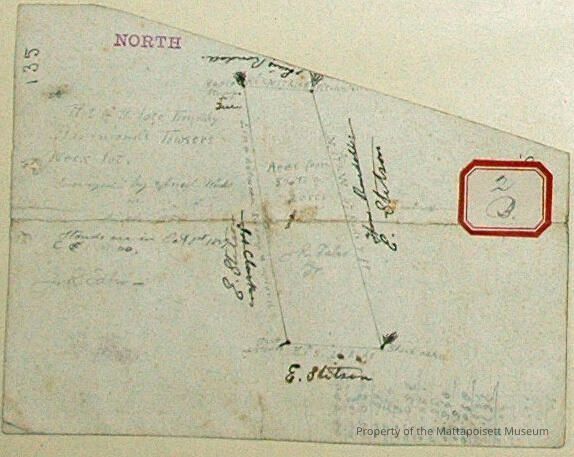
Plot of the late Timothy Hammond's Towser's Neck lot. Wood lot later owned by J. R. Taber Jr. Surveyed by Ansel Weeks in March 1856. Area from 8 1/2 to 9 acres. Abutting properties: E. Stitson, Lewis Randall. Town Plot 900N by 0E. 1856, 1882.Acquisition
Accession
0000.5Acquisition Method
GiftLexicon
Nomenclature 4.0
Nomenclature Primary Object Term
BookNomenclature Sub-Class
Other DocumentsNomenclature Class
Documentary ObjectsNomenclature Category
Category 08: Communication ObjectsLOC Thesaurus for Graphic Materials
Plans, Maps, Surveyors, SurveyingSearch Terms
Towser's Neck, Ansel Weeks surveyorArchive Details
Date(s) of Creation
Mar 1856Archive Notes
Publication Notes: March 1856Other Names and Numbers
Other Numbers
Number Type
Other NumberOther Number
2bRelationships
Related Person or Organization
Person or Organization
TaberPerson or Organization
StitsonPerson or Organization
RandallGeneral Notes
Note
Notes: Notecard:
1. Hammond, Timothy (154A, 2B)
Wood Lot - Towser's Neck.
Later owned by J. R. Taber Jr.
Town Plot 900N by 0E
1856. 1882
2. Taber, Jos. R. (154A, 2B)
Timothy Hammond
Wood Lot
Line between Stetson established
Town Plot 900N by 0E
1852 & 1883
Status: OKCreated By
admin@catalogit.appCreate Date
December 2, 2014Updated By
admin@catalogit.appUpdate Date
August 28, 2021