Name/Title
BookEntry/Object ID
0000.5.13Scope and Content
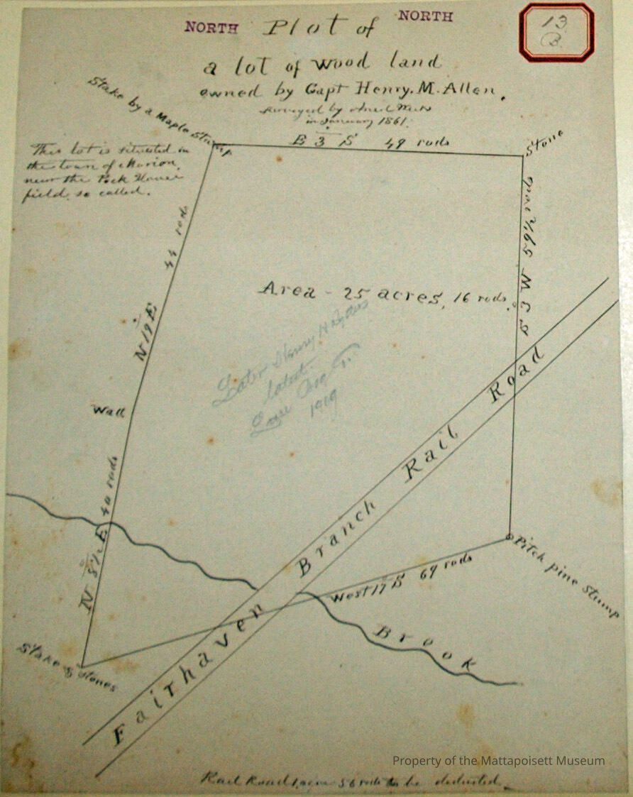
Plot of a woodland owned by Capt. Henry M. Allen. Surveyed by Ansel Weeks January 1861. This lot is situated in the town of Marion near the Pack House Field so called. Later owned by Joseph Allen (19b), later owned by Henry H. Ryder, Latest Luce Bog Co. (1909). Area 25 acres, 16 rods. Fairhaven Branch Railroad cuts through at 1 acre, 56 rods deducted. Abutter of Kane Landing. See also 19b for additional information on plot.Acquisition
Accession
0000.5Acquisition Method
GiftLexicon
Nomenclature 4.0
Nomenclature Primary Object Term
BookNomenclature Sub-Class
Other DocumentsNomenclature Class
Documentary ObjectsNomenclature Category
Category 08: Communication ObjectsLOC Thesaurus for Graphic Materials
Land, Plans, Surveying, Surveyors, MapsSearch Terms
Marion, MA, Kane's Landing, Fairhaven Branch Railroad, Barden's Brook, Ansel Weeks surveyor, Luce Bog CompanyArchive Details
Date(s) of Creation
Jan 1861Archive Notes
Publication Notes: January 1861Other Names and Numbers
Other Numbers
Number Type
Other NumberOther Number
13bRelationships
Related Person or Organization
Person or Organization
AllenPerson or Organization
RyderGeneral Notes
Note
Notes: Notecard:
1. Allen, Henry M. (13B & 19B, 304B)
Wood Lot - Marion.
Crossed by Railroad.
Later owned by Henry H. Ryder.
Then Luce Bog Co.
Town Plot 850N by 450E.
1861
2. Allen, Joseph (same as above)
3. Ryder, Henry H. (13B & 19B)
"Henry Allen" Wood Lot - Marion
Later owned by Luce Bog Co.
Town Plot 850N by 450E
1861
4. Luce Bog Co. (13B & 19B)
"Henry Allen" wood lot - Marion
Town Plot 850N by 450E
1861
Status: OKCreated By
admin@catalogit.appCreate Date
December 2, 2014Updated By
admin@catalogit.appUpdate Date
August 28, 2021