Name/Title
BookEntry/Object ID
0000.5.35Scope and Content
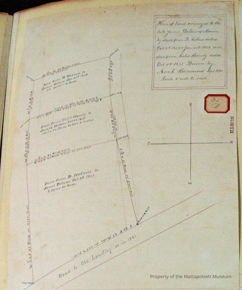
Plan of land conveyed to the late James Delano of Marion by deeds from B. Holmes dated October 8, 1823 (3 Acres, 111 Rods) and January 24, 1829 (1 1/4 Acres, 18 Rods) and deed from Caleb Handy dated October 9, 1821 (1 Acre, 98 Rods, 40 Feet, 6 Inches). Drawn by Noah Hammond September 1890. Scale 5 rods to 1 inch. Includes Road to Old Landing as in 1823.Acquisition
Accession
0000.5Acquisition Method
GiftLexicon
Nomenclature 4.0
Nomenclature Primary Object Term
BookNomenclature Sub-Class
Other DocumentsNomenclature Class
Documentary ObjectsNomenclature Category
Category 08: Communication ObjectsSearch Terms
Marion, MA, Noah Hammond surveyor, Road to Old LandingArchive Details
Archive Notes
Date(s): 1823, 1829, 1821, 1890
Publication Notes: 1823, 1829, 1821, 1890Other Names and Numbers
Other Numbers
Number Type
Other NumberOther Number
35bRelationships
Related Person or Organization
Person or Organization
HolmesPerson or Organization
HandyPerson or Organization
DelanoGeneral Notes
Note
Notes: Notecard:
1. Delano, J. Marion (26A, 35B, 303B)
Land lot of Ebenezer Holmes 1823, 1829.
Caleb Handy 1821.
W. side of road to Old Landing.
2. Handy, Caleb (35B & 303B, 26A)
Lot - Marion
Near road to Old Landing
Sold to Jas. Delano
1890
3. Holmes, Barnabas (35B & 303B, 26A)
2 Lots - Marion
Sold to Jas. Delano
1890
Status: OKCreated By
admin@catalogit.appCreate Date
December 8, 2014Updated By
admin@catalogit.appUpdate Date
August 28, 2021