Name/Title
BookEntry/Object ID
0000.5.133Scope and Content
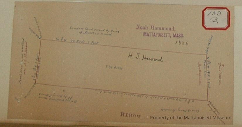
H. T. Howard 8 3/4 acre plot on Fairhaven/Mattapoisett line. Abutters: Sanders land owned by Heirs of Matthew Howard, Noah Hammond woodland now A. J. Tinkham, land of Henry Mendall, and Briggs woodland owned by Henry T. Howard.Acquisition
Accession
0000.5Acquisition Method
GiftLexicon
Nomenclature 4.0
Nomenclature Primary Object Term
BookNomenclature Sub-Class
Other DocumentsNomenclature Class
Documentary ObjectsNomenclature Category
Category 08: Communication ObjectsLOC Thesaurus for Graphic Materials
LandSearch Terms
Real Estate, Noah Hammond surveyor, Fairhaven, MA, Mattapoisett, MAArchive Details
Date(s) of Creation
1886Archive Notes
Publication Notes: 1886Other Names and Numbers
Other Numbers
Number Type
Other NumberOther Number
133bRelationships
Related Person or Organization
Person or Organization
HowardPerson or Organization
SandersPerson or Organization
BriggsPerson or Organization
TinkhamPerson or Organization
Mendell/MendallGeneral Notes
Note
Notes: Notecard:
Howard, H. T. (133B)
Wood lot.
West bound - Mattapoisett & Fairhaven town line.
Town Plot 400N by 650W
1886
Status: OKCreated By
admin@catalogit.appCreate Date
December 15, 2014Updated By
admin@catalogit.appUpdate Date
August 28, 2021