Name/Title
BookEntry/Object ID
0000.5.169Scope and Content
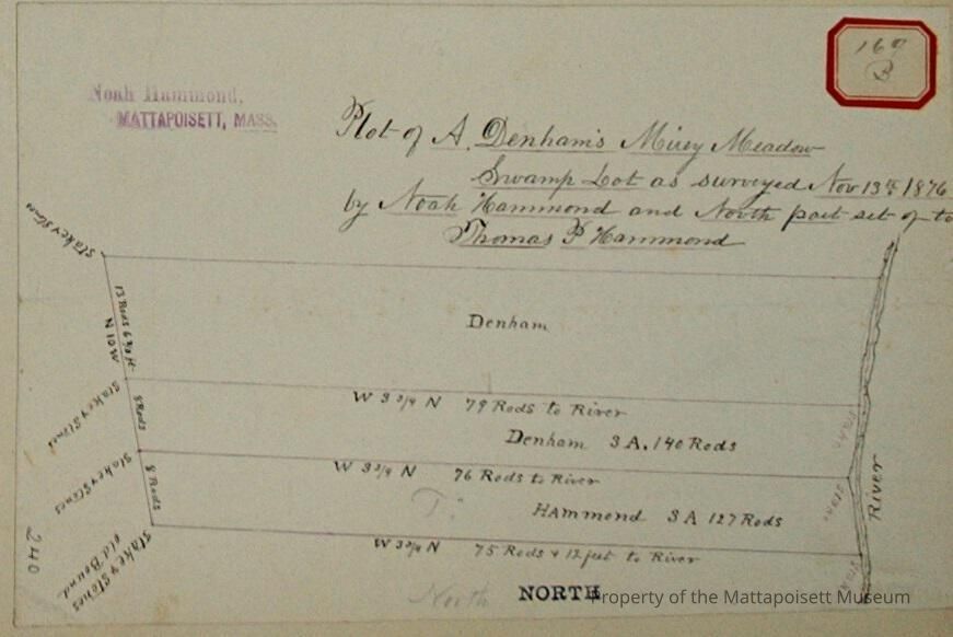
Plot of A. Denham's Mirey Meadow swamp lot as surveyed November 13th, 1876 by Noah Hammond and north part-set-of to Thomas Hammond. Three divisions, Denham, Denham (3 acres and 140 rods) and Hammond (3 acres ad 127 rods). River to the west.Acquisition
Accession
0000.5Acquisition Method
GiftLexicon
Nomenclature 4.0
Nomenclature Primary Object Term
BookNomenclature Sub-Class
Other DocumentsNomenclature Class
Documentary ObjectsNomenclature Category
Category 08: Communication ObjectsLOC Thesaurus for Graphic Materials
Land, Land subdivisionSearch Terms
Real Estate, Noah Hammond surveyor, Mattapoisett RiverArchive Details
Date(s) of Creation
1876Archive Notes
Publication Notes: 1876Other Names and Numbers
Other Numbers
Number Type
Other NumberOther Number
169bRelationships
Related Person or Organization
Person or Organization
DenhamPerson or Organization
HammondGeneral Notes
Note
Notes: Notecard:
1. Denham, A. (139A & 169B)
Mirey Meadow Swamp Lot
On Mattapoisett River
Part set off to Thos. P. Hammond
Town Plot 475N by 400W
1876
2. Hammond, Thos P. (139A & 169B)
Part of A. Dunham's Mirey Meadow Swamp lot on Mattapoisett River
Later owned by C. B. Hammond
Town Plot 475N by 400W
1876
3. Hammond, C. B. (139A & 169B)
Part of A. Dunham's Mirey Meadow Swamp lot
On Mattapoisett River
Town Plot 475N by 400W
1876
Status: OKCreated By
admin@catalogit.appCreate Date
December 10, 2014Updated By
admin@catalogit.appUpdate Date
August 28, 2021