Name/Title
BookEntry/Object ID
0000.5.218Scope and Content
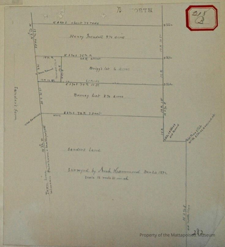
Surveyed by Noah Hammond, December 22, 1892. Scale 16 rods to the inch. Sanders land and farm border to the south and west. Bonney lot (8 ¼ acres), Briggs' lot (6 acres). Henry Mendell (9 ¼ acres). Mendell's 1 ½ acre. Fairhaven and Mattapoisett town line on west.Acquisition
Accession
0000.5Acquisition Method
GiftLexicon
Nomenclature 4.0
Nomenclature Primary Object Term
BookNomenclature Sub-Class
Other DocumentsNomenclature Class
Documentary ObjectsNomenclature Category
Category 08: Communication ObjectsLOC Thesaurus for Graphic Materials
Land, Land subdivisionSearch Terms
Real Estate, Fairhaven, MA, Mattapoisett, MA, Noah Hammond surveyorArchive Details
Date(s) of Creation
1892Archive Notes
Publication Notes: 1892Other Names and Numbers
Other Numbers
Number Type
Other NumberOther Number
218bRelationships
Related Person or Organization
Person or Organization
Mendell/MendallPerson or Organization
BriggsPerson or Organization
SandersPerson or Organization
BonneyGeneral Notes
Note
Notes: Notecard:
1. Howard, H. (218B)
Briggs' Lot
Near Mattapoisett and Fairhaven town line
Town Plot 425N by 650W
1892
2. Howard, H. T. (218B)
Bonney Lot
West line Mattapoisett and Fairhaven town line
Town Plot 400N by 650W
1892
3. Mendall, Henry (218B)
Wood lot
West line Mattapoisett and Fairhaven town line
Town Plot 450N by 650W
1892
Status: OKCreated By
admin@catalogit.appCreate Date
December 17, 2014Updated By
admin@catalogit.appUpdate Date
August 28, 2021