Name/Title
BookEntry/Object ID
0000.5.242Scope and Content
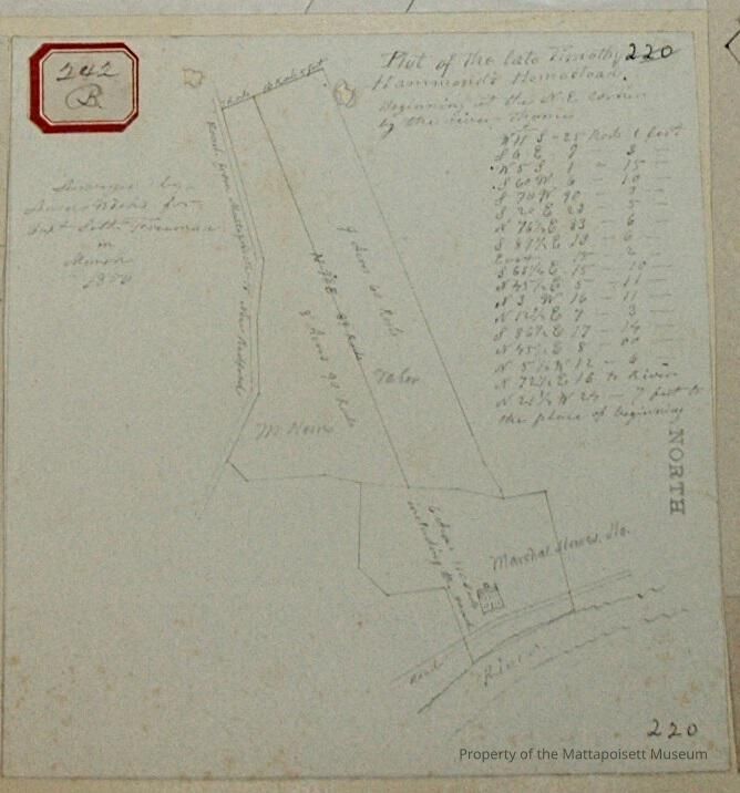
Plot of the late Timothy Hammond's Homestead. Beginning at the northeast corner by the river thence. Surveyed by Ansel Weeks for Capt. Seth Freeman in March 1850. Three lots; Marshal Howes Homestead at 6 acres and 110 rods including the road. M. Howes at 8 acres and 90 rods. Taber at 9 acres and 60 rods. On Road from Mattapoisett to New Bedford and river.Acquisition
Accession
0000.5Acquisition Method
GiftLexicon
Nomenclature 4.0
Nomenclature Primary Object Term
BookNomenclature Sub-Class
Other DocumentsNomenclature Class
Documentary ObjectsNomenclature Category
Category 08: Communication ObjectsLOC Thesaurus for Graphic Materials
Land, Land subdivision, HomesteadingSearch Terms
River Road, Old Road to New Bedford, Ansel Weeks surveyorArchive Details
Date(s) of Creation
1856Archive Notes
Publication Notes: 1856Other Names and Numbers
Other Numbers
Number Type
Other NumberOther Number
242bRelationships
Related Person or Organization
Person or Organization
HammondPerson or Organization
TaberPerson or Organization
HowesPerson or Organization
FreemanGeneral Notes
Note
Notes: Notecard:
1. Hammond, Timothy (242B)
Homestead and wood lot - River Road
Part owned later by J. B. Taber and part by Marshal Howes
Town Plot 50N by 475W
1856
2. Hamlin, James (242B)
Marshal Howes House lot
River Road
Town Plot 25N by 425W
1856
3. Howes, Marshal (242B, 251B)
Part of Timothy Hammond land
Fairhaven Road
Town Plot 25N by 475W
1856 & 1869
4. Howes, Marshal (242B)
Timothy Hammond Homestead House lot
On River Road
Later owned by James Hamlin
Town Plot 25N by 425W
1856
5. Taber, J. B. (242B)
Part of Timothy Hammond land
Behind Marshal Howe's place
Town Plot 50N by 475W
1856
Status: OKCreated By
admin@catalogit.appCreate Date
December 17, 2014Updated By
admin@catalogit.appUpdate Date
August 28, 2021