Note
Notes: Notecard:
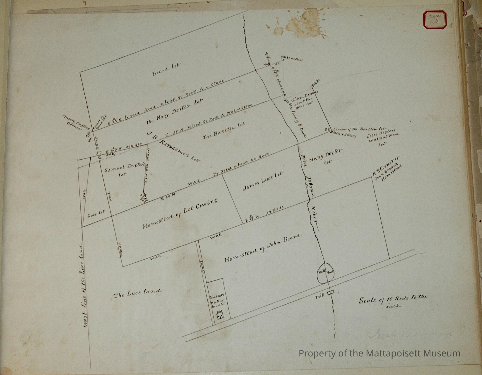
1. Beard, John (235B & 244B, 91A)
Wood lot south of Keziah Randall's.
North part owned by Samuel Dexter Jr.
South part owned by Joseph L. Meigs
Town Plot 200N by 375E
2. Beard, John (235B & 244B, 91A)
Homestead on Marion Road
At Macomber's Mill Pond
Later owned by Joseph Nye
Town Plot 100N by 50)E
3. Beard, John (235B & 244B)
Wood lot crossed by Randall Road
North part owned later by Samuel Dexter Jr.
South part owned by Joseph L. Meigs
Town Plot 200N by 450E
4. Cowing, Lot (235B & 244B, 91A)
Homestead in rear of Friends' Meeting House
Later part of Westgate Land
Town Plot 100N by 450E
5. Dexter, Mary (235B & 244B, 91A)
Part of John Beard Homestead
Sold to J. Edwards in 1786
Town Plot 150N by 450E
6. Dexter, Samuel (235B & 244B, 91A)
Lot west of Samuel Dexter Jr's Cushing Lot
Town Plot 150N by 400E
7. Dexter, Samuel Jr. (235B & 244B, 91A, 198A)
North part of John Beard Wood lot
Near Keziah Randall's
Town Plot 200N by 400E
8. Dexter, Samuel Jr. (235B & 244B, 91A)
J. B. Ransom Cushing wood lot
In rear of Friends' Meeting House
Town Plot 150N by 450E
9. Edwards, J. (235B & 244B, 91A)
Part of John Beard Homestead
Town Plot 150N by 450E
10. Luce, James (235B & 244B, 91A)
Land in rear of Lot Cowing's
Later part of Westgate land
Town Plot 125N by 500E
11. Meigs, Joseph L. (235B & 244B, 91A, 198A)
South part of John Beard wood lot
South of Keziah Randall's
Owned later by Dennis Mahoney
Town Plot 175N by 400E
12. Nye, Joseph (235B & 244B, 91A)
Beard Homestead at Macomber's Mill Pond
Town Plot 100N by 500E
13. Westgate (235B & 244B, 91A)
Land in read of Friends' Meeting House
Town Plot 100N by 425E
Status: OK