Note
Notes: Notecard:
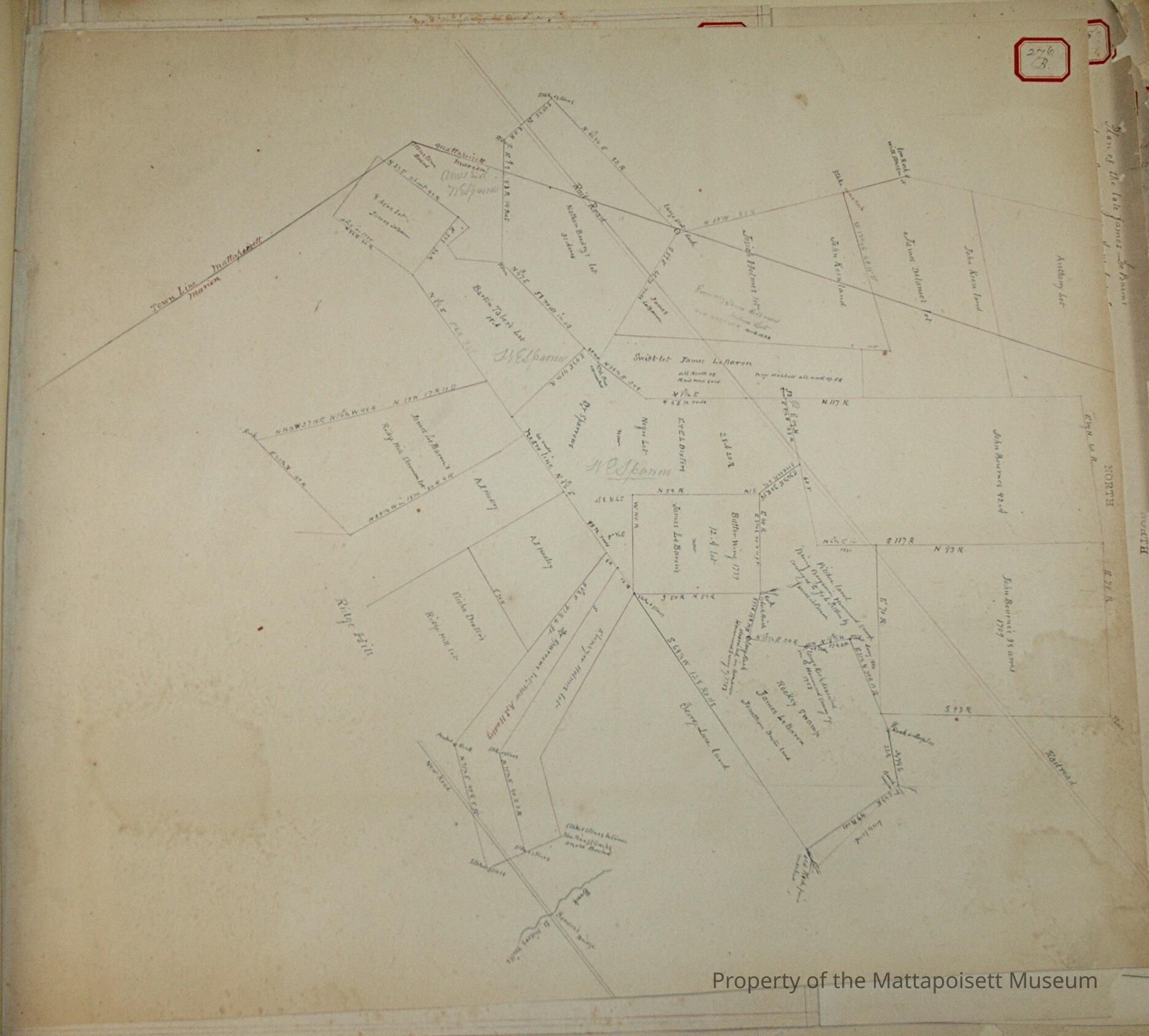
1. Delano, Geo. (4A & 99B, 272B, 276B, 290B).
Keen Wood Lot and Stephen Hammond Lot.
Crossed by Mattapoisett and Marion Town Line.
Town Plot 800N by 300E
1875
2. Delano, Capt. Jas. (4A & 99B, 272B, 276B, 290B)
Keen Wood Lot and Stephen Hammond Lot.
Crossed by Mattapoisett and Marion town line.
Owned later by George Delano.
Town Plot 800N by 300E.
1875
3. Hammond, Stephen (4A & 99B, 272B, 276B, 290B)
4 acre lot - Marion
Later part of George Delano Keen Lot.
Town Plot 800N by 325E
1875
4. Haskell, Geo (103B, 272B, 276B, 290B)
J. Holmes and Swift Lots - Marion.
Crossed by Mattapoisett and Marion town line.
Part south of Railroad to James LeBaron.
Lots owned later by Dennis Mahoney.
Town Plot 750N by 300E
Copy of old plan of 1794-5
5. Holmes, J. (103B, 272B, 276B, 290B)
Marion town line.
Later owned by Haskell
Town Plot 750N by 300E
Copy of old plan of 1794-5
6. Keen, John (103B, 272B, 276B, 290B)
Wood land crossed by Mattapoisett and Marion town line - Marion
Later known as Haskell's J. Holmes and Swift Lots.
Copy of old plan of 1794-5
7. LeBaron, James (74A & 16B, 307B & 311B, 313B & 342B, 162B, 276B, 290B, 35A)
Butler Wing or Twelve-Acre Lot
Rocky Swamp - Marion
Town Plot 700N by 400E
1856, 1874, 1889, 1891
8. LeBaron, James (103B, 272B, 276B, 290B)
J. Holmes and Swift Lots - Marion
Part south of Railroad
Town Plot 700N by 300E
9. Mahoney, Dennis (74A & 16B, 307B & 311B, 313B & 342B, 162B, 276B, 290B)
Butler Wing or Twelve-Acre lot
Rocky Swamp - Marion
Town Plot 700N by 400E
1874, 1856, 1889, 1891
10. Mahoney, Dennis (103B, 272B, 276B, 290B)
Haskell's J. Holmes and Swift Lots - Marion
Town Plot 750N by 300E
Copy of old plan of 1794-5
11. Sparrow, W. E. (74A & 16B, 342B, 276B)
Negro Lot - Marion
Town Plot 700N By 350E
12. Hadley, A. J. (87A, 165B & 216B, 233B & 296B, 162B, 276B, 36A)
"Boot" lot - Marion
South-east of Luce's Rocky Swamp
Town Plot 650N by 450E
1864
13. Holmes, Josiah and Ebenezer (87A, 165B & 216B, 233B & 296B, 162B, 276B)
"Boot" lot - Marion
South east of Luce's Rocky Swamp.
Later north part owned by A. J. Hadley, south part owned by W. E. Sparrow and sold by him to Hadley.
Town Plot 650N by 450E
1864
14. LeBaron, James (162B, 276B, 36A)
Ridge Hill lot - Marion
Owned later by Dennis Mahoney
Town Plot 600N by 350E
15. Mahoney, Dennis (162B, 276B, 36A)
James LeBaron Ridge Hill Lot - Marion
Town Plot 600N by 350E
16. Sparrow, W. E. (87A, 165B & 216B, 233B & 296B, 162B, 276B)
North part of "Boot" lot
South-east of Rocky Swamp - Marion
Sold to A. J. Hadley
Town Plot 650N by 450E
1864
17. Ames, Nathaniel (71A & 276B)
Wood lot near Solomon's
Later owned by W. E. Sparrow
Town Plot 600N by 300E
1856
18. Boodry, Nathan (205B, 272B & 276B)
Wood lot
Crossed by Mattapoisett and Marion town line and by Railroad
Town Plot 675N by 250E
1856
19. Bourne, John (276B, 290B)
Wood lot near Rocky Swamp - Marion
Included George Delano lot, Judah Hathaway lot and part of H. M. Allen lot and J. & C. Pitcher lot
Town Plot 850N by 400E
20. Hammond, Benjamin (276B, 290B, 304B)
Lot north of Rocky Swamp - Marion
Sold by James LeBaron to J. & C. Pitcher.
On plot south part of J. & C. Pitcher land
Town Plot 750N by 400E
21. LeBaron, James (74A & 276B)
Eight-acre lot
Near Solomon's Place
Town Plot 600N by 250E
1857, 1874
22. LeBaron, James (307B & 311B, 276B & 313B, 35A)
Jonathan Dexter Rocky Swamp lot - Marion
Town Plot 750N by 450E
1889 & 1891
23. LeBaron, James (276B, 290B, 304B)
Benjamin Hammond lot
North of Rocky Swamp - Marion
Sold to J. & C. Pitcher
On plot south part of J. & C. Pitcher land
Town Plot 750N by 400E
24. Pitcher, J. & C. (1A, 3A, 276B, 290B, 304B)
Pitcher land near Rocky Swamp - Marion
South part of James LeBaron's Benjamin Hammond lot
North part John Bourne land
Town Plot 800N by 400E
1864 & 1896
25. Sparrow, W. E. (71A, 276B)
Nathaniel Ames' wood lot
Near Solomon's Place
Town Plot 600N by 300E
1856
26. Sparrow, W. E. (74A & 276B)
Barton Taber lot - Marion
Near Mattapoisett and Marion town line
Town Plot 650N by 300E
27. Taber, Barton (74A & 276B)
Wood lot - Marion
Near Mattapoisett and Marion town line
Later owned by W. E. Sparrow
Town Plot 650N by 300E
Status: OK