Note
Notes: Notecard:
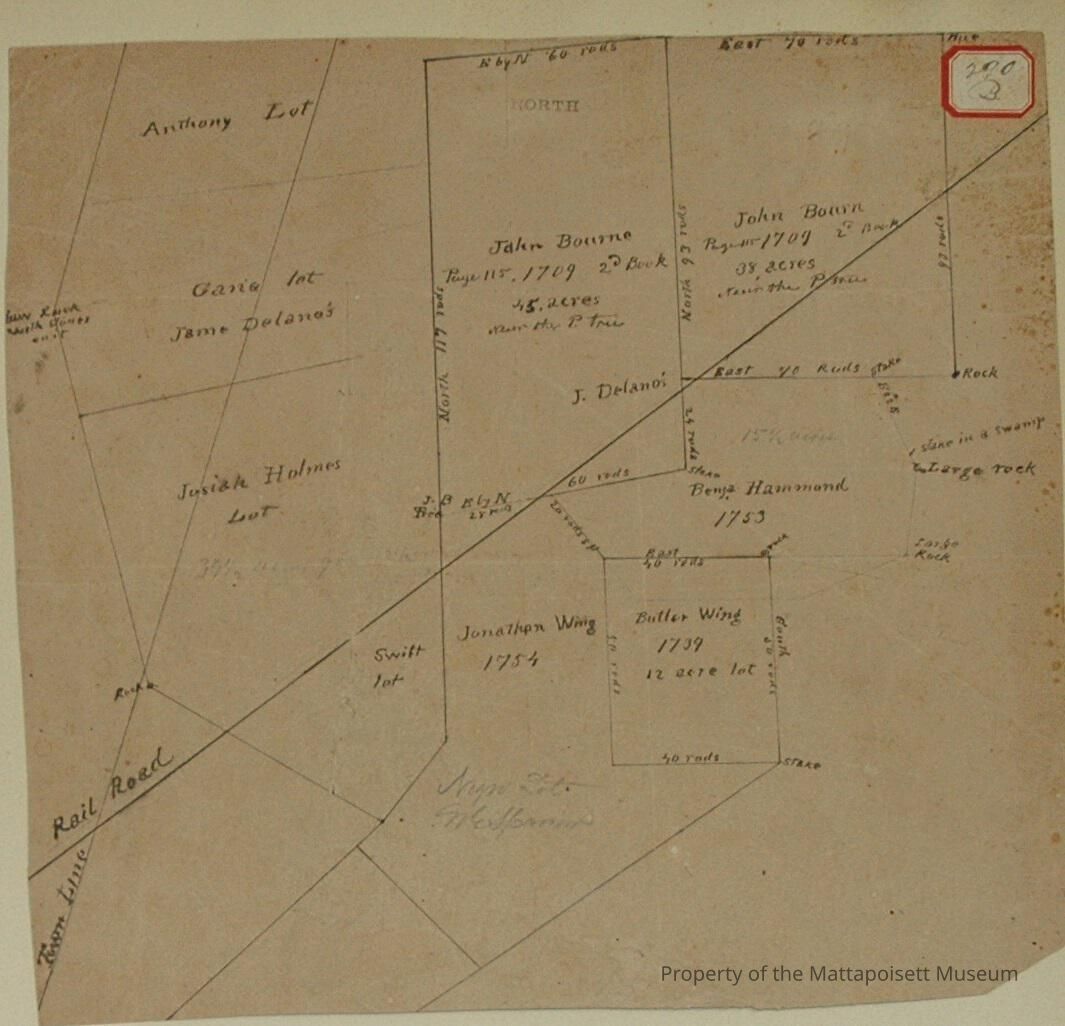
1. Delano, George (4A & 99B, 272B, 276B, 290B).
Keen Wood Lot and Stephen Hammond Lot.
Crossed by Mattapoisett and Marion Town Line.
Town Plot 800N by 300E
1875
2. Delano, Capt. James (4A & 99B, 272B, 276B, 290B)
Keen Wood Lot and Stephen Hammond Lot.
Crossed by Mattapoisett and Marion town line.
Owned later by George Delano.
Town Plot 800N by 300E.
1875
3. Hammond, Stephen (4A & 99B, 272B, 276B, 290B)
4 acre lot - Marion
Later part of George Delano Keen Lot.
Town Plot 800N by 325E
1875
4. Haskell, George (103B, 272B, 276B, 290B)
J. Holmes and Swift Lots - Marion.
Crossed by Mattapoisett and Marion town line.
Part south of Railroad to James LeBaron.
Lots owned later by Dennis Mahoney.
Town Plot 750N by 300E
Copy of old plan of 1794-5
5. Holmes, J. (103B, 272B, 276B, 290B)
Marion town line.
Later owned by Haskell
Town Plot 750N by 300E
Copy of old plan of 1794-5
6. Keen, John (103B, 272B, 276B, 290B)
Wood land crossed by Mattapoisett and Marion town line - Marion
Later known as Haskell's J. Holmes and Swift Lots.
Copy of old plan of 1794-5
7. LeBaron, James (74A & 16B, 307B & 311B, 313B & 342B, 162B, 276B, 290B, 35A)
Butler Wing or Twele-Acre Lot
Rocky Swamp - Marion
Town Plot 700N by 400E
1856, 1874, 1889, 1891
8. LeBaron, James (103B, 272B, 276B, 290B)
J. Holmes and Swift Lots - Marion
Part south of Railroad
Town Plot 700N by 300E
9. Mahoney, Dennis (74A & 16B, 307B & 311B, 313B & 342B, 162B, 276B, 290B)
Butler Wing or Twelve-Acre lot
Rocky Swamp - Marion
Town Plot 700N by 400E
1874, 1856, 1889, 1891
10. Mahoney, Dennis (103B, 272B, 276B, 290B)
Haskell's J. Holmes and Swift Lots - Marion
Town Plot 750N by 300E
Copy of old plan of 1794-5
11. Hammond, Benjamin (276B, 290B, 304B)
Lot north of Rocky Swamp - Marion
Sold by James LeBaron to J. & C. Pitcher.
On plot south part of J. & C. Pitcher land
Town Plot 750N by 400E
12. LeBaron, James (276B, 290B, 304B)
Benjamin Hammond lot
North of Rocky Swamp - Marion
Sold to J. & C. Pitcher
On plot south part of J. & C. Pitcher land
Town Plot 750N by 400E
Status: OK