Plot 342B

Plot 342B

Name/Title

Book

Entry/Object ID

0000.5.342

Scope and Content

This is the plat of 49 acres and 156 rods of land laid out to Jonathan Wing. Situate and lying on or near the "parth" that leedeth a cros the iron ore from "Sicepeain" to "Modepoiset" and agoining to the easterly end of a tract of land laid out to Butler Wing August the 4th 1739 and also in "cluds" a nother peace of twelve aycre of land laid out to D. Wing on the same day where the iron ore is to the west of the Rocky Swamps beginning for the first bound at the stake the northeast corner bound of the western most peace of D. Wing's. Land as doth appear by this plat and the remining part of this plat being 42 acors and 76 rods of land which we laid out to D. Jonathan Wing 20 acros there of on the 96 acor grant to Samuell Arnols Shear at first and the remaining part being 17 acros and 76 rods is laid out on the 48 acor grant to the D. Arnols Shear at first. Rochester, January the 15th 1754. Signed Seth Hiller, surveyor, Silas Briggs and Shube (?) Barlow, chairmen.

Acquisition

Accession

0000.5

Acquisition Method

Gift

Lexicon

Nomenclature 4.0

Nomenclature Primary Object Term

Book

Nomenclature Sub-Class

Other Documents

Nomenclature Class

Documentary Objects

Nomenclature Category

Category 08: Communication Objects

LOC Thesaurus for Graphic Materials

Land

Search Terms

Real Estate, Rochester, MA, Marion, MA, Rocky Swamp

Archive Details

Archive Notes

Date(s): 1856, 1874, 1889, 1891 Publication Notes: 1856, 1874, 1889, 1891

Other Names and Numbers

Other Numbers

Number Type

Other Number

Other Number

342b

Relationships

Related Person or Organization

Person or Organization

Wing

Person or Organization

Briggs

Person or Organization

Barlow

General Notes

Note

Notes: Notecard: 
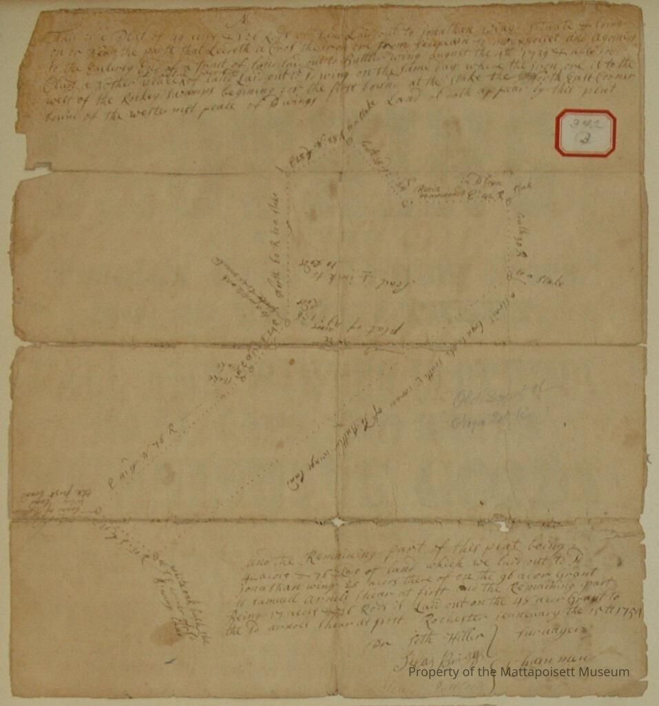
1. LeBaron, James (74A & 16B, 307B & 311B, 313B & 342B, 162B, 276B, 290B, 35A) Butler Wing or Twelve-Acre Lot Rocky Swamp - Marion Town Plot 700N by 400E 1856, 1874, 1889, 1891 2. Mahoney, Dennis (74A & 16B, 307B & 311B, 313B & 342B, 162B, 276B, 290B) Butler Wing or Twelve-Acre lot Rocky Swamp - Marion Town Plot 700N by 400E 1874, 1856, 1889, 1891 3. Sparrow, W. E. (74A & 16B, 342B, 276B) Negro Lot - Marion Town Plot 700N By 350E 4. Wing, Jonathan (74A & 16B, 342B) Old survey. Includes so-called Negro Lot and the Butler Wing or Twelve-acre lot. Former owned by W. E. Sparrow, the later by James LeBaron Town Plot 700N by 350E Status: OK

Created By

admin@catalogit.app

Create Date

December 8, 2014

Updated By

admin@catalogit.app

Update Date

August 28, 2021