Name/Title
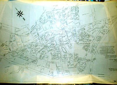
Security Realty Map of Brantwood Section, Short Hills, 1927Entry/Object ID
1976.015.004Description
Large unframed architect's-linen map of the Brantwood section of Short Hills. Printed text on map notes: "This map is filed by Security Realty Company for information only and is not a dedication or factor in the dedication of any estate right or easment (sic). All rights and estates except such as may be expressly granted by deed or deeds hereafter made are reserved except that every owner, his or her heirs or assigns of any portion of he lands herein plotted has a right of way over the roads and highways shown hereon as the same are or may hereafter be opened. The line of every road or highway may be changed by Security Realty Company with the consent of the owners of the property abuting the proposed tobe changed. Surveyed by W.H.V. Reimer, CE, Orange NJ 1899-1911" and "Deeds plotted hereon up to October 8th 1923 (F.U.Tr.Co.?) See search69318 for deeds added Feb. 3rd 1927 (F.W.R.?)"
Map is labeled 34-1102. It has three sharp vertical fold lines and three less-sharp fold lines. Overall wrinkling, some pencil notes and red pencil marks.Acquisition
Accession
1976.015Source or Donor
UnknownDimensions
Height
53-1/2 inWidth
29-1/2 in