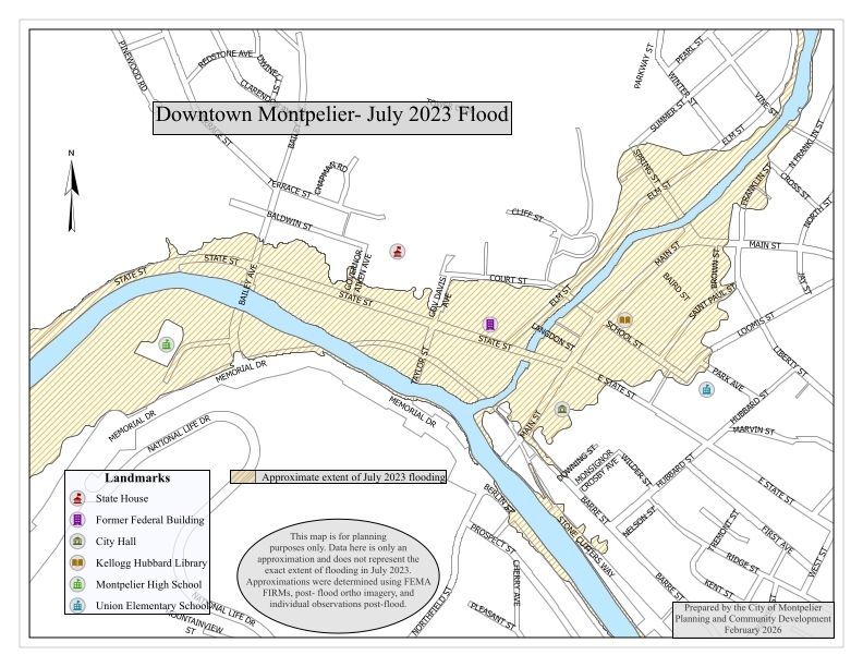
Name/Title
Map of Flooding in Downtown Montpelier, July 2023Entry/Object ID
2026.2.1Context
"After record-breaking amounts of rain in July, Montpelier received an additional 5.28 inches of rain on July 10th, an all-time high since records began to be collected in 1948. Throughout July, Montpelier set a monthly rainfall record when we experienced a whopping 12.06 inches of rain. This caused rivers to crest at 21.29 feet, inundating Downtown Montpelier and the surrounding neighborhoods with several feet of water." -- https://www.montpelier-vt.org/610/Flood-GuideAcquisition
Accession
2026.2Source or Donor
City of Montpelier, Vt.Acquisition Method
GiftLexicon
Nomenclature 4.0
Nomenclature Secondary Object Term
MapNomenclature Primary Object Term
CartographNomenclature Sub-Class
Graphic DocumentsNomenclature Class
Documentary ObjectsNomenclature Category
Category 08: Communication ObjectsSearch Terms
Maps--Vermont--MontpelierMap Details
Maker or Creator
City of Montpelier, Vt.Illustrator
Gauthier, NicholasDate Published
February 24, 2026Relationships
Related Places
Place
City
Montpelier, Washington County, Vermont