Name/Title
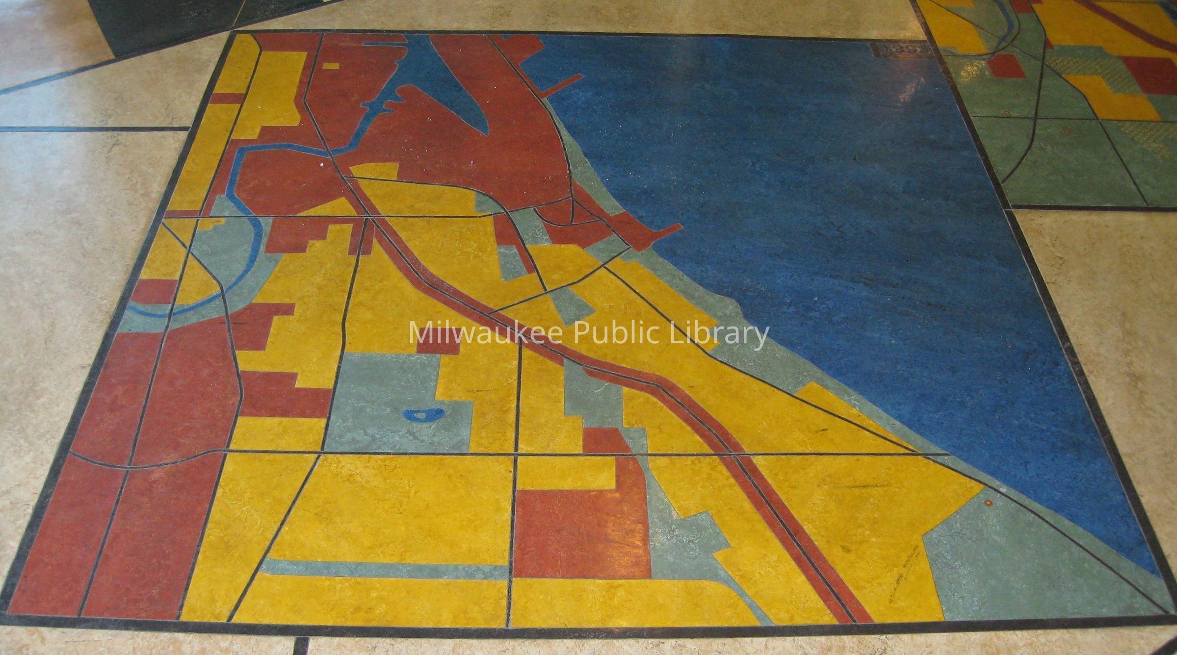
Maps of Bay View: Bay View in 1993Context
The third of three mosaic maps of linoleum, representing Bay View at three stages of its development: at the time of settlement in 1836 [other sources variously mis-date the map as 1832 and 1846]; in 1900, when a steel mill on the lakefront spurred the community's growth; and a third in 1993.The map at this record is for Bay View in 1836.
From the artist in 2014: "The maps are accurate to the best of my ability (in 1993) to represent settlement patterns of the Bay View area at three points, 1836, 1900, and 1993, using a four color legend for water and greenspace, work and business/commercial. The settlement by Europeans/ or eastern immigrants was sparse in 1836, and I used the device of the double circle (red w/ the yellow center) to represent homesteads, indicating a home/ commercial combination. Notice also that the Jones Island native settlement is yellow with red dots in 1836, indicating a similar mix. Wetlands, were prevalent in 1836, and are represented by green w/ blue dots."
From the 9/9/1993 MJ: "'As we researched, we found changes in the direction of the Kinickinnic River, the harbor and the land, and we found established native communities,' Peot-Shields said. 'The maps in the lobby are intended to be educational for the children and adults who visit the library.'"
From the 10/25/1993 MS: "[Flanary] emphasized the irregular siting of the building by positioning an historical mural inside the library's entrance along an accurate magnetic axis, but which appears to be askew on the foyer floor.
Bay View grew out of farms and Indian camps scattered around what the pioneer map-maker Increase A. Lapham declared to be 'an impassable marsh.'
The mouth of the Kinnickinnic River caused the formation of what we know as Jones Island, which was then a real island inhabited by Indians. The mouth of Deer Creek to the south also attracted a large Indian village.
The community took shape with the draining of the marshes. A controversial decision was made to cut the entrance to Milwaukee's harbor north of Jones Island, not south, for ship traffic. The mouth of the Kinnickinnic was diverted, and that led to the formation of a natural bridge to Jones Island.
The mouth of Deer Creek was dredged by the Milwaukee Iron Co. to allow lake freighters to transship their cargoes directly at the mill. When the mill operation ended, the mouth of the creek was filled. In fact, the creek was forced to flow underground, as it does even today.
This history is represented in three linoleum mural maps Flanary has created in the foyer [...] The 1836 Indian trails can be recognized in the 1993 thoroughfares."
James Auer (in the 10/31/1993 MJS) said that the mosaic panels "[form] a schematized map of the community at three stages in its development. History is thus both afoot and underfoot in this attractive blending of the very old and the very new."
The 6/5/1995 MJS says that "Peter Flanary's indoor and outdoor embellishments of the new Milwaukee Public Library branch in Bay View imaginatively comment on the community's history and industrial heritage."
The 2/17/1997 MJS says the maps are "charming," and that "[a]lthough it is easy to find specific sites in these brightly colored mosaics, they work beautifully as abstractions--bold and fluid and welcoming."
Copies of the articles are available in the accession record at 1993.1.Collection
Artwork Collection, Wisconsin Art Collection, City of Milwaukee/Milwaukee Arts Board CollectionAcquisition
Accession
1993.1Source or Donor
Peter FlanaryAcquisition Method
PurchaseInscription/Signature/Marks
Type
DateLocation
Upper rightTranscription
"1993"Dimensions
Dimension Description
Installation Size (3 maps)Height
94 inWidth
252 in