Name/Title
Map, Outcrops of Magnetite of Property of Moose Mountain Ltd. Township of Hutton, District of Nipissing, Ontario, Canada, August 17, 1908Entry/Object ID
2019.003.032Description
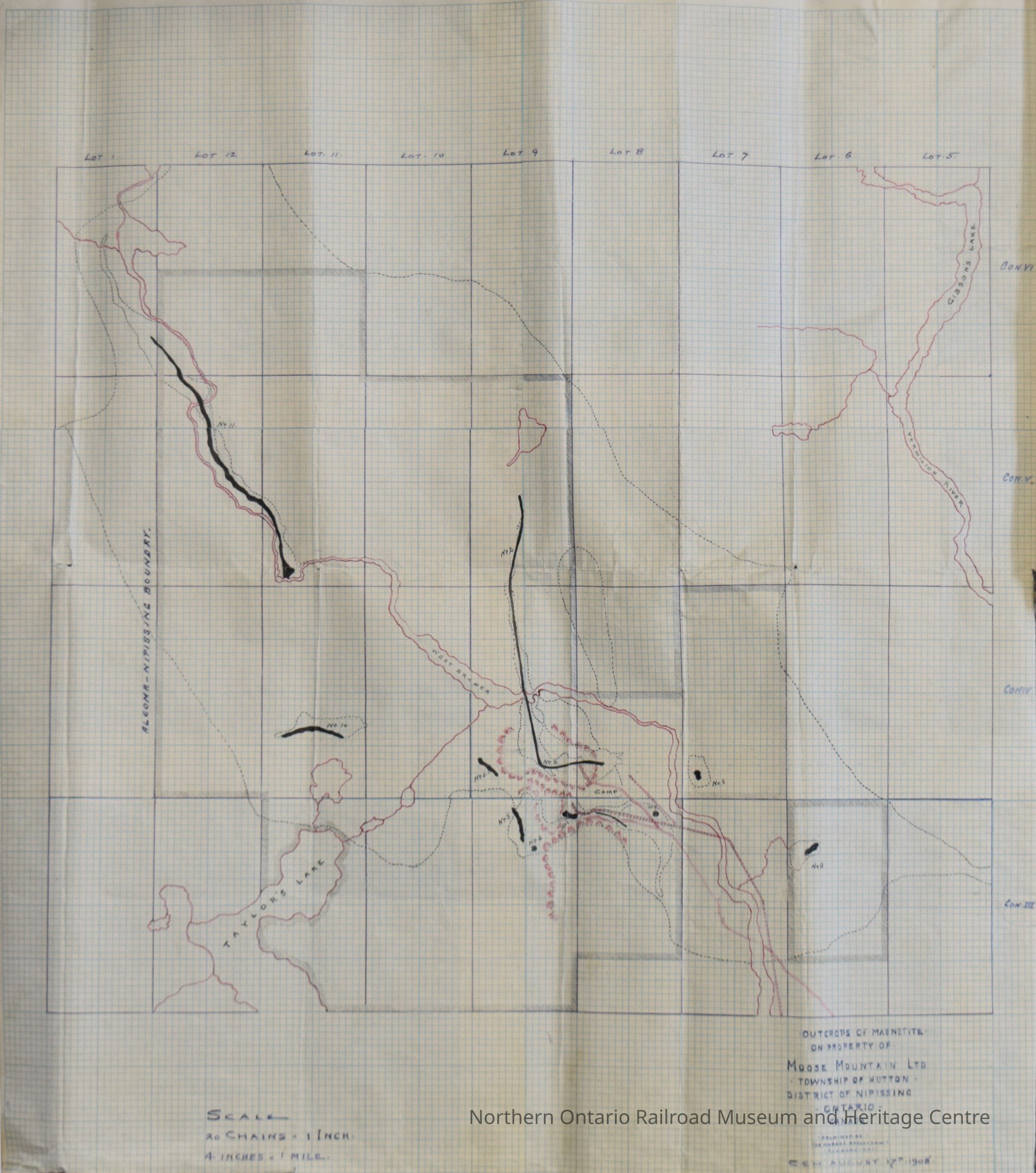
Hand drawn map, outcrops of Magnetite of Property of Moose Mountain Ltd. Township of Hutton, District of Nipissing, Ontario, Canada, August 17, 1908, Drawn by De Morest Stull Low, Sudbury Ontario, C.E.H. August 17th 1908. Scale "20 chains = 1 inch, 4 inches = 1 mile". Grid map, labeled with lot and concession numbers. magnetite outcrops marked in black. Railway and geographical features drawn in red, including Taylor's Lake, Gibsons Lake, and the Vermillion River. "Algoma Nipissing Boundry" marked on the far left.Collection
Library ArchiveAcquisition
Source (if not Accessioned)
Hans MatthewsNotes
Date Acquired: May 2019
Method of Acquisition: Donation - With ConditionsLexicon
Nomenclature 4.0
Nomenclature Secondary Object Term
MapNomenclature Primary Object Term
CartographNomenclature Sub-Class
Graphic DocumentsNomenclature Class
Documentary ObjectsNomenclature Category
Category 08: Communication ObjectsLegacy Lexicon
Class
DocumentaryCategory
CommunicationMap Details
Place Published
City
Greater SudburyCountry
CanadaContinent
North AmericaState/Province
OntarioDate Published
1908Map Notes
Materials: PaperOther Names and Numbers
Other Numbers
Number Type
Item NumberOther Number
31252Dimensions
Height
57-3/16 inWidth
50.4 cmCondition
Notes
This map is in fair condition. there are four creases in the map from left to right, and one top to bottom, where the map was folded into five parts and again in half. The right edge of the map has four small tears, in from the edge, and two in the bottom edge, a quarter of the way across from the left side.Created By
admin@catalogit.appCreate Date
March 14, 2022Updated By
normhclibrary@gmail.comUpdate Date
April 21, 2022