Name/Title
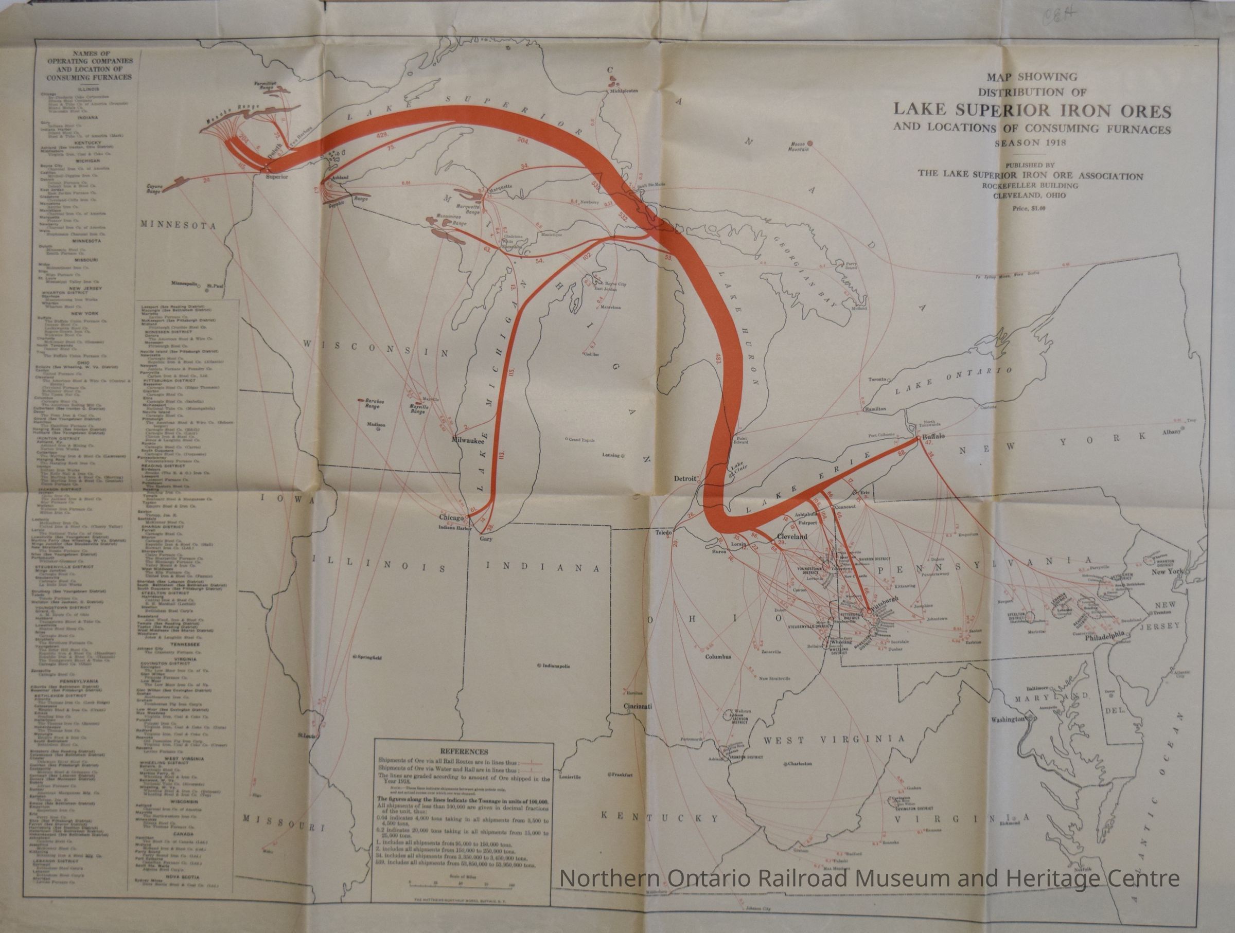
Map, Distribution of Lake Superior Iron Ores, an Locations of Consuming Furnaces Season 1918Entry/Object ID
2019.003.034Description
A map detailing the distribution of Lake Superior Iron Ores, and locations of consuming furnaces, in the season of 1918. Covers the States of Minnesota, Wisconsin, Minnesota, Ohio, Missouri, Pennsylvania, New York, Illinois, Indiana, Kentucky, West Virginia, and Virginia. The routes are marked in orange. Includes a list of operating companies and the locations of consuming furnaces.Collection
Library ArchiveAcquisition
Source (if not Accessioned)
Hans MatthewsNotes
Date Acquired: May 2019
Method of Acquisition: Donation - With ConditionsLexicon
Nomenclature 4.0
Nomenclature Secondary Object Term
MapNomenclature Primary Object Term
CartographNomenclature Sub-Class
Graphic DocumentsNomenclature Class
Documentary ObjectsNomenclature Category
Category 08: Communication ObjectsLegacy Lexicon
Class
DocumentaryCategory
CommunicationMap Details
Place Published
City
Cleveland, OhioState/Province
OhioCountry
United States of AmericaContinent
North AmericaDate Published
1918Map Notes
Materials: PaperOther Names and Numbers
Other Numbers
Number Type
Item NumberOther Number
31254Dimensions
Height
60-13/16 inWidth
31.3 cmCondition
Notes
This map is in fair condition. there are three creases in the map from left to right, and one top to bottom, where the map was folded into four parts and again in half. There are three small holes, down the center of the map, where the vertical and horizontal creases meet.Created By
admin@catalogit.appCreate Date
March 14, 2022Updated By
normhclibrary@gmail.comUpdate Date
April 20, 2022