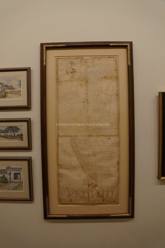
Transcription
[Page 1]
[In the hand of Samuel F. Moses]
Charlotte and Campbell Counties 14th April 1823
Surveyed for Mr John Henry, One Thousand Seven hundred and Six Acres of Land, lying in both of the above Counties, and bounded as follows; Beginning at Edward W. Henry’s Corner forked ash on Stanton River. In Charlotte County at A, Thence along E.W. Henry’s, lines, as per letters. N80¼° [“t” written in pencil] E167 poles to a forked white oak. Thence N61½° E61 poles To Pointers [“c” written in pencil] in a bottom, thence [loss of document] [“C”/”G” written in pencil] E184 poles to a crook [“d” written in pencil] N7¾° W6 poles to Pointers [“e” written in pencil] N10½° E156 poles to a crook N20° E30 poles to a white [“g” written in pencil] oak at [loss of document] N10½° E20 [“h” written in pencil] poles N13° E44 poles to sourwood Pointer in Palmers line [“B” written in pencil], thence his line N45¼° W4 poles to a corner Dogwood [”c” written in pencil] on Wellcraws line, thence along his lines, S22° W74 poles to a corner in the lick [“L” written in pencil] branch N61½° W60½ poles, to a corner Rock at the Fan trough branch N61½° W16 [“m” written in pencil] poles. N51 ½° W14 poles. N53¼° W26 Poles to a Poplar [“o” written in pencil]. N3½° E118 poles to a falling [“f” written in pencil] post oak on John Henry’s road thence crossing the County line, and running into Campbell N1⅓° W164 poles to Pointers [“g” written in pencil]. N36° E31 poles to Hezekiah Brooks’ small [“R” written in pencil] Pine, on the Island Ford road, thence along his lines, and the road, N16° W20 poles to a lay white oak on the [“s” written in pencil] road. N24° W15 po [poles] to Pointers Just over the [“t” written in pencil] road, thence N54° W76 poles crossing the road twice to Mr Bailey’s corner [“u” written in pencil] Poplar, thence bending on his line & road SW 76° 12 poles to a white oak on the [“v” written in pencil] road, thence along the road as it meanders. S81° W16 poles, S66° W28 [“w” written in pencil] poles S51° W48 poles S60° W15 [“y” written in pencil] poles, and S74½° W10 poles to Pointers [“z” written in pencil] in Wm [William] Walkers line, on the aforesaid road, thence his lines S57° E8 poles to a white oak Stump [“h” written in pencil], S54 ½° [“B” written in pencil] W80 poles thence [document loss], S52° W118 poles to Pointers [“D” written in pencil]. S29° W14½ poles to a [“E” written in pencil] sour wood, S21½° W18½ poles to a corner Poplar [“F” written in pencil] by a branch, following the same as it meanders, reduced to direct lines as follows S60¾° W44 [“b”/”G” written in pencil] po [poles] S43¾° W39 [“H” written in pencil] po N86⅓° W58 [“I” written in pencil] po S60½° W14 [“j” written in pencil] poles S44° W29 poles to Falling [“k” written in pencil] river at the Rocky ford, and at the mouth of the branch, a corner Beach being the Station [loss of document] at Falling [“K” written in pencil] river, as it meanders, reduced to direct S44½° E20 po S33⅓° E30 po S45° E22 po S26⅓° E50 po, S29° E16 poles S22° E19 po S33° E12 po S23° E20 po S62° E16 po S73° E14 po S49½° E14 po S41½° E30 po S26° E16 po S22° E34 po S10° 49 ½ poles S2° S23° E20 po S74½° [“x” written in pencil] E16 po [“x” written in pencil] N65½° E20 po [“x” written in pencil] N81½° E36po S52° E24 po S22° E12 po S10° E10 po SE 15 ½° E11 po SE 20 ½° E23 poles S9° E52 poles S22° W12 po and S37½° W22 poles to Stanton River, thence down Stanton River as it meanders, reduced to a direct line S2½° E107½ poles to the Beginning, This Survey proved in bearing and distance, made by
Samuel F. Moses, Surv. C. C.
PS. There is between 150 and 160 Acres of Stanton River Low grounds. There may be as much as 160 acres, not more, ascertain’d by Intersection
[“RED HILL” written in a large, decorative font at the bottom of the page]
[Addition written in another hand]
Virginia: In the Clerks Office of the Circuit Court of Campbell County, – July 31st, – 1908
The foregoing plat of Red Hill was this day presented and admitted to record.
The condition of said plat shows that from age and much usage, a narrow strip extending through the writing below the peak, giving the Courses and distance, from top to bottom across the lines has been broken in turn ink and is missing, and said correcting has since been supplied. The figure giving the number of degrees East, immediately before “E.184 poles at a crook” are missing, not being supplied.
Teste,
S. C. Goggin, Clerk
[Addition written in a third hand]
In Charlotte Circuit Court Clerk’s Office March 30th 1908.
The foregoing plat was this day filed in this office and admitted to record.
Teste: J. C. Carrington C.Language
English