Name/Title
Douglas 1873 Map photocopyEntry/Object ID
2008.10.06Description
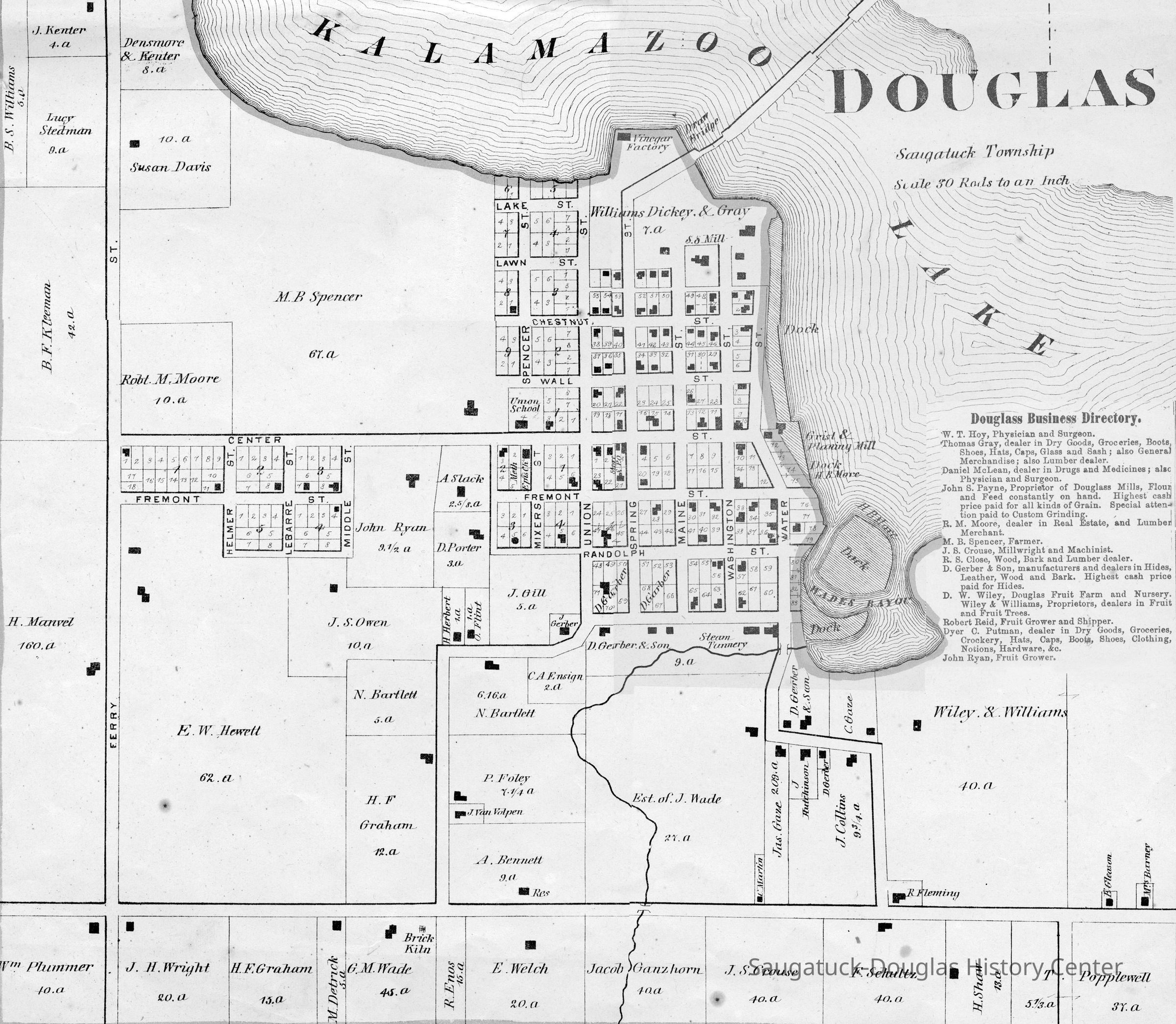
A photocopy map of Douglas from the 1873 "Atlas of Allegan County, Michigan" by C.O. Titus. The archive has complete copies of the Atlas.Context
This plat map displays the large, outlying land parcels owned by B.S. Williams, J. Kenter, Lucy Stedman, Densmore & Kenter, Susan Davis, Robert M. Moore, M.B. Spencer, Williams Dickey & Gray, B.F. Kleeman, H. Hanvel, E.W. Hewett, John Ryan, J.S. Open, N. Partlett, H.F. Graham, A Slack, D. Porter, H. Herbert, O. Flint, J. Gill, C.A. Ensign, D. Gerber & Son, P. Foley, A. Bennett, J. Wade, Jos. Gaze, J. Hutchinson, J. Collins, Wiley & Williams, R. Fleming, H. Shaw, F. Scultz, J.S. Crouse, Jacob Granzhorn, E. Welch, R. Enos, G.M. Wade, M. Detrick, H.F. Graham, J.H. Wright, J. Van Volpen, and William Plummer.
Site noted include a Brick Kiln, Vinegar Factory, Draw Bridge, Dock, Grist & Planing Mill, H.B. More dock, Wade's Bayou, Steam Tannery, the Union School and S.S. Mill
On the left side is a Douglas Business Directory (partially cut off) that names W.T. Hoy, Thomas Gray, Daniel McLean, John S. Payne, R.M. Moore, M.B. Spencer, J.S. Crouse, R.S. Close, D. Gerber, D.W. Wiley, Robert Reid, Dyer C. Putnam, and John Ryan.Collection
Education and schools, Maps, Commercial businessesCataloged By
Voss, MaryAcquisition
Accession
2008.10Source or Donor
Budd, Nancy J. 1922-2010Acquisition Method
DonationLocation
Drawer
Flat Files drawer 16 plat and property mapsRelationships
Related Person or Organization
Person or Organization
Hoy, Dr. William Tarlton 1818-1900, Gray, Thomas 1820-1895, McLean, Daniel or David, Payne, John Sage 1834-1900, Moore, R.M., Crouse, Jonas S. 1824-1899, Close, Robert S., Gerber, Daniel 1820-1890, Wiley, David W. 1837-1927, Putnam, Dyer Conger Sr. 1843-1894, Ryan, John 1826-1893, Reid, Robert Sr. 1827-1906, D. Gerber & Son Tannery/Tannery Hill, Foley, Peter 1825-1905General Notes
Note
Status: OK
Status By: Mary Voss
Status Date: 2008-05-19Create Date
May 19, 2008Update Date
March 16, 2025