Name/Title
River mouth survey 1856Entry/Object ID
2024.42.04Description
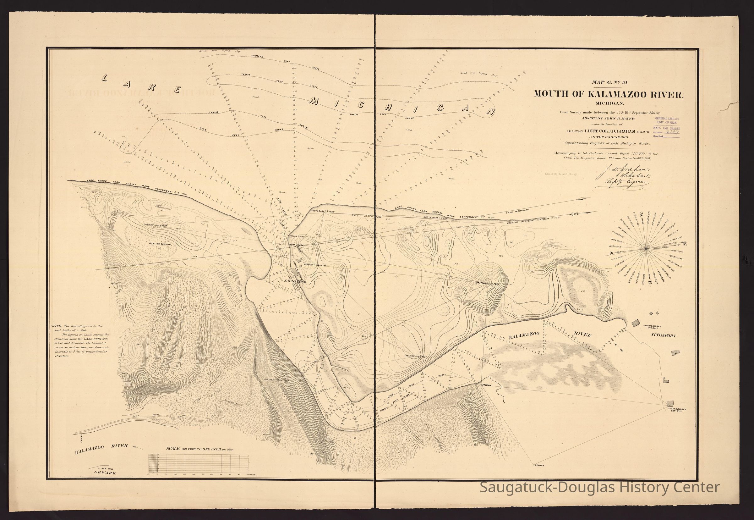
Digital scan of a historic map that shows the dune contours and water depth soundings at the mouth of the river. Indications of a burying ground, a beacon light, the Kalamazoo River light house and station, the Nickels warehouse (area labeled Saugatuck), five structures in a southern-riverbank version of Fishtown, a lone building at Shriver's Bend, two Stockbridge saw mills and five buildings in Singaport [sic], the road from Newark, ferry crossing and Newark saw mill.Context
Documentation that in 1856, the lighthouse area was named "Saugatuck" and the town we know of as Saugatuck today was named "Newark" by government surveyors.Collection
1830 Settlement, pioneer era, 1836 Singapore, 1835 Logging and Lumbering, 1845 Fishing, commercialCataloged By
Winthers, SallyAcquisition
Accession
2024.42Source or Donor
Clark, ChrisAcquisition Method
Donation, unconditionalLocation
* Untyped Location
Digital data in CatalogItRelationships
Related Person or Organization
Person or Organization
Nichols, Stephen D. 1806-1887, Nichols Warehouse c1856, Kalamazoo Lighthouses 1839/1858/1956-present, FishtownGeneral Notes
Note
Full citation: "Mouth of Kalamazoo River, Michigan from survey made between the 2d & 10th September 1856 by assistant John R. Mayer, under the direction of Brevet Lieut. Col. J.D. Graham, Major, U.S. Top. Engineers. Superintending Engineer of Lake Michigan Works." In the digital collection UM Clark Library Maps. https://quod.lib.umich.edu/c/clark1ic/x-001293831/39015091897143. University of Michigan Library Digital Collections. Accessed September 09, 2024.Note
North oriented toward right.
"Soundings are in feet and tenths of a foot."
"The figures on land express the elevations above the lake surface in feet and decimals. The horizontal curves or contour lines are drawn at intervals of 5 feet of perpendicular elevation."
"Accompanying Lt. Colonel Graham's annual report (no. 200) to the Chief Top. Engineer, dated Chicago September 30th 1857."Create Date
September 9, 2024Update Date
October 5, 2024