Name/Title
Photograph Aerial View of Shelburne Village looking SouthwestEntry/Object ID
2025.13.1Description
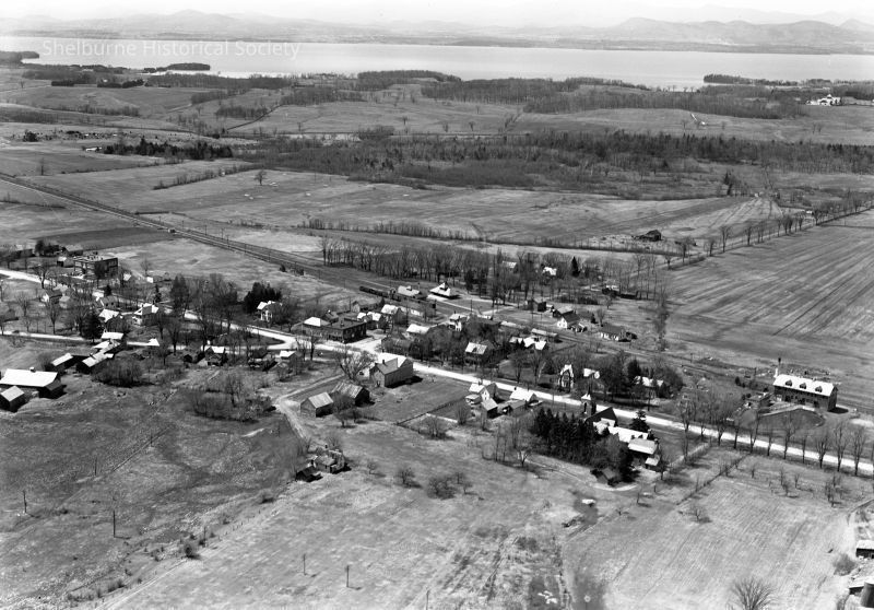
Taken April 28, 1939, this aerial photograph looks over the village community of Shelburne towards Lake Champlain and the distant Adirondacks of New York. The village consists of a series of buildings clustered around the main thoroughfare (Vermont Route 7). The surrounding landscape is flat and mainly open, with the exception of the wooded shoreline of Lake Champlain, and other clusters of trees. Train tracks run parallel to Route 7 on the lake side.Photograph Details
Type of Photograph
DigitalSubject
Shelburne Vermont Village and land West - View looking southwestSubject Place
* Untyped Subject Place
Shelburne Village, United StatesTown
ShelburneState/Province
VermontContinent
North AmericaContext
This photograph was taken 28 April 1939.Made/Created
Date made
Apr 28, 1939Place
Town
ShelburneState/Province
Vermont* Untyped Place
United StatesContinent
North AmericaNotes
Width: 800 pixels, Height: 570 Pixels, Resolution: 96 dpiLexicon
Getty AAT
Concept
digital photographsOther Names
Name Type
Catalogue InformationOther Name
Photographs: Lathrop Collection ACC# 1986.301.455- .607 4K1/ 1986. 310. 508Name Type
FilenameOther Name
Landscape Change Program - Filename: LS16432_000.jpgName Type
FilenameOther Name
Landscape Change Program - Original Filename: SMKB057.jpgCopyright
Type of License
Copright Statement - In CopyrightCopyright Holder
Henry Sheldon Museum of Vermont HistoryRestrictions
Credit: "Collection of the Henry Sheldon Museum of Vermont History, Middlebury, Vermont". Permission of the low-resolution images (below 300 dpi) on the Shelburne Historical Society website. The high-resolution images are for onsite research purposes only. Please, do not share or distribute the latter without additional permission.Notes
Permission to Publish Visual Materials, Henry Sheldon Museum 14 Nov 2025Created By
Boucher, DavidCreate Date
March 11, 2023Updated By
Boucher, DavidUpdate Date
November 17, 2025