Name/Title
Map of Chittenden Count Vermont H.F. Walling 1857Entry/Object ID
2025.0.1Description
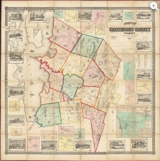
A digital file of the 'Map of Chittenden County Vermont' created by Walling, Henry Francis (1825-1888) in 1857. The map shows householders names and includes 18 city insets, table of distances, statistics and illustrations. Inset map of Burlington and Winooski include business directories. The Shelburne Historical Society has downloaded the digital file of the map from DigitalCommonwealth.org, the Primary (full resolution, uncompressed) TIF, 933 MB. The physical copy of this digital map resides in the Boston Public Library. Another mounted and framed copy is located in the Shelburne Vermont Town Clerks Office.Context
This map is a primary source map because it shows roads, householders, schools, railroad, and a few geographic features in the town of Shelburne, Vermont in 1857. it also includes a drawing of the residence of Henry Morse.Lexicon
Nomenclature 4.0
Nomenclature Secondary Object Term
MapNomenclature Primary Object Term
CartographNomenclature Sub-Class
Graphic DocumentsNomenclature Class
Documentary ObjectsNomenclature Category
Category 08: Communication ObjectsMap Details
Maker or Creator
Walling, Henry Francis (1825-1888)Area or Region
County
Chittenden CountyState/Province
Vermont* Untyped Area or Region
United StatesContinent
North AmericaPublisher
Baker, Tilden & Co.Place Published
City
Boston* Untyped Place Published
Massachusetts, United StatesRegion
NortheastContinent
North AmericaDate Published
1857Printer
H.F. Walling & Co.Date Printed
1857Medium
PaperMap Notes
Engraved, Printed, Colored & Mounted by H.F. Walling & Co.Copyright
Type of License
Copyright Statement - No Copyright United StatesCreated By
Boucher, DavidCreate Date
May 15, 2025Updated By
Boucher, DavidUpdate Date
May 15, 2025