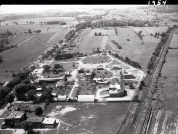
This aerial view image was taken facing South and includes the Shelburne Museum as of 1954. The building in the bottom left is Shelburne High School. The Rutland Railroad tracks can be seen on the right. The top left shows farm fields. The Shelburne Historical Society has a digital image provided by the Shelburne Museum who has the original print.
Photograph Details
Type of Photograph
Gelatin Print - silver bromide
Subject
This aerial view image was taken facing South and includes the Shelburne Museum as of 1954. The building in the bottom left is Shelburne High School. The Rutland Railroad tracks can be seen on the right. The top left shows farm fields. The Shelburne Historical Society has a digital image provided by the Shelburne Museum who has the original print.
Subject Place
Town
Shelburne
State/Province
Vermont
* Untyped Subject Place
United States, Shelburne Village
Continent
North America
Made/Created
Date made
circa 1954
Lexicon
Nomenclature 4.0
Nomenclature Secondary Object Term
Print, Photographic
Nomenclature Primary Object Term
Photograph
Nomenclature Sub-Class
Graphic Documents
Nomenclature Class
Documentary Objects
Nomenclature Category
Category 08: Communication Objects
Other Names and Numbers
Other Numbers
Number Type
Reference Number
Notes
Shelburne Museum Catalogue Record Number: PS4.1.2-18
UVM Landscape Change Program Filename Reference Number: LS33237_000