Name/Title
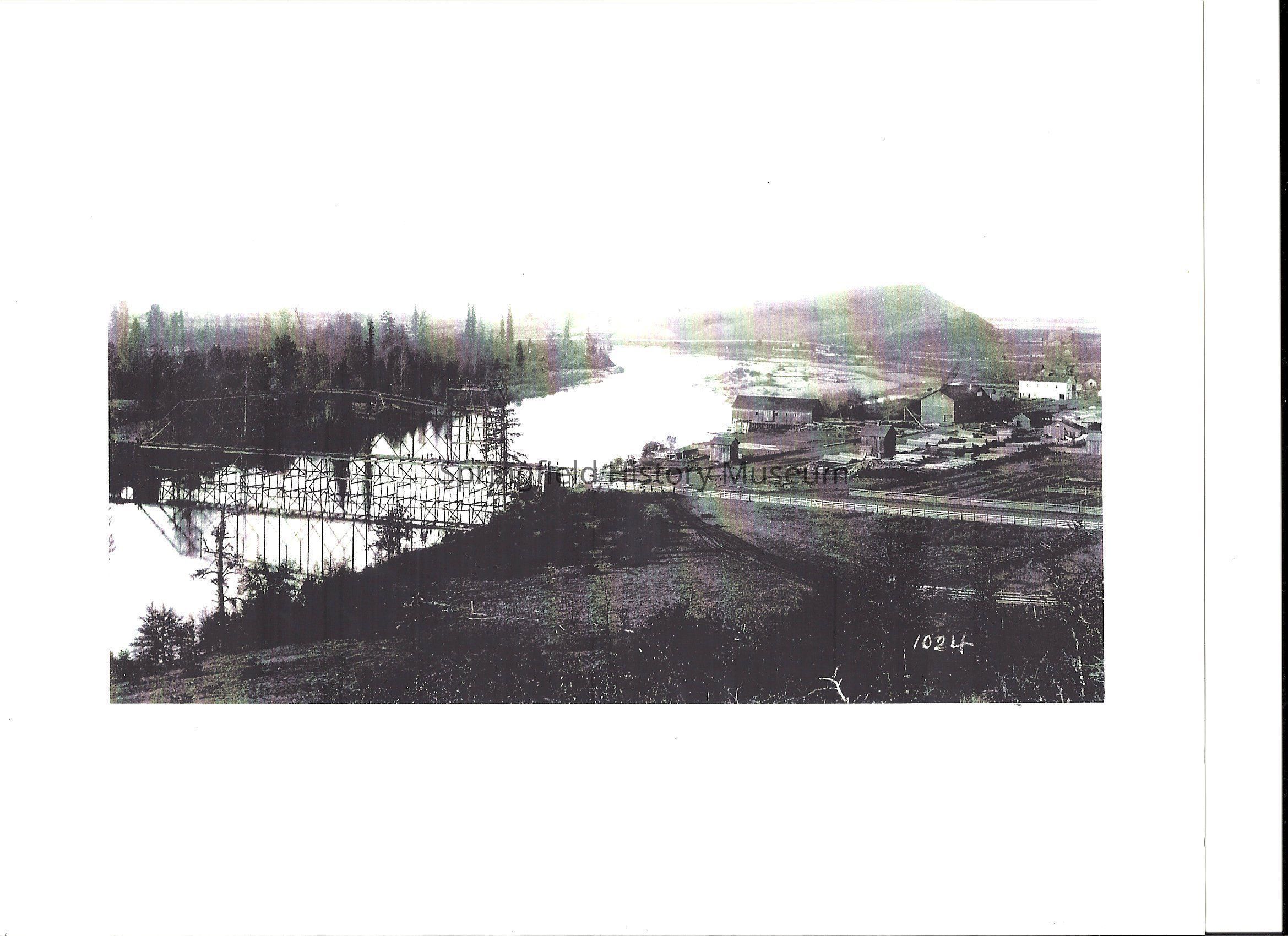
Photograph of northwest view of the Springfield Flouring Mill and Steel Bridge, Springfield, Oregon, 1882Entry/Object ID
2012.018.001Tags
Not in collectionDescription
1) Copy from a Transparency LCHM-25
Photograph of northwest view of Springfield, Oregon at about South F Street at Kelly Butte, with Steeling Bridge over the Willamette River, 1882
The "Steel Bridge" is in final stages of construction over Willamette River, on left side of photograph. The steel bridge was a one-lane bridge connecting what is now Franklin Boulevard ( at about east 19th ave, formerly called the Springfield wagon road) with south D st . This Bridge replaced the wooden wagon bridge that was destroyed in 1881, and was used until the Main st bridge was opened in 1929.
The Springfield Flouring Mill ( 1854-1930: also called the roller mills) is the large, 2-story structure located in the right center of the photograph ( to left and front of the 2- story white building). South Mill st runs along the right side of the flouring mill, and the original mill pond ( with logs in it) can be seen further to the right.
The long building on the river bank, to the left of the flouring mill, is the Springfield Manufacturing Company sawmill (1866-1882). Sawn lumber is visible stacked along the east side of south Mill st, just south of south B st. The original mill pond discharge channel runs along the south side of the flouring mill, and under the sawmill. This mill was destroyed by fire in June 1882. A new sawmill was immediately" constructed on the site. A planning mill was constructed south of the flouring mill by 1884. The reconstructed mill operated until 1902.
The original Brigg's sawmill ( 1853-1866) would been located approximately 375b feet to the north of the Springfield Manufacturing company sawmill, with the west end probably overhanging a water flume. This location is on the south side of the present-day mill race, opposite and to the southeast of the Willamalane Park & Recreation District office building (100 south Mill st).
The long building on the river banks in the location of Briggs' Ferry . must be the old ferry boat house or covered Ferry House. It is poor condition after being put out of business when the wooden wagon bridge was built in 1875?.Photograph Details
Subject Place
City
SpringfieldCounty
Lane CountyState/Province
OregonCountry
United States of AmericaContinent
North AmericaAcquisition
Accession
2012.018Acquisition Method
GiftDimensions
Height
9 inWidth
4 inDimension Notes
9x4Copyright
Type of License
Copyright Not Evaluated, http://rightsstatements.org/vocab/CNE/1.0/Copyright Details
Images on this website are provided by the Springfield History Museum for educational purposes. Researchers assume all responsibility for copyright questions. For inquiries, please contact springfieldmuseum@springfield-or.gov, or use the Image Request Link.