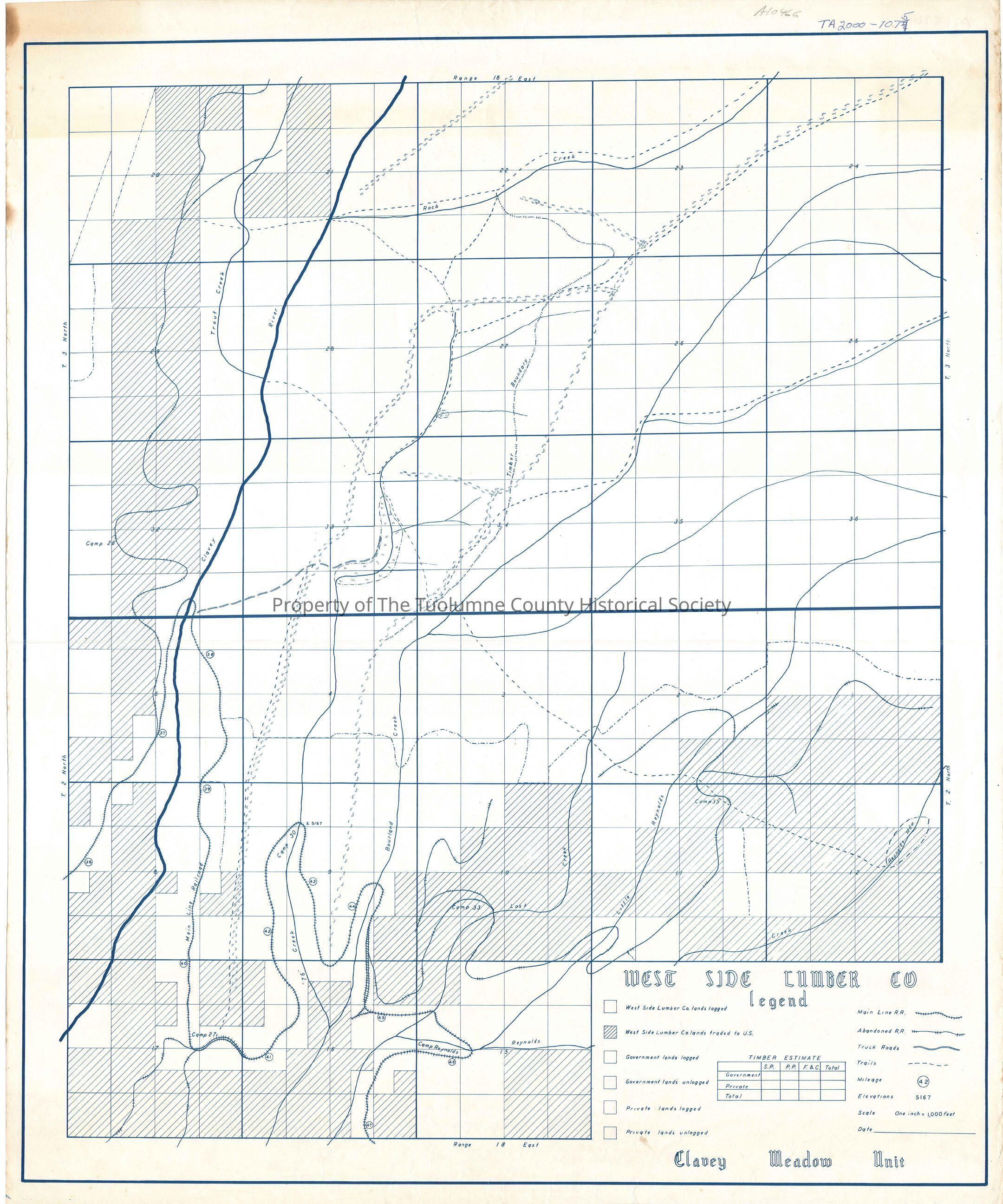
West Side Lumber Co. Clavey Meadow Unit

Name/Title

West Side Lumber Co. Clavey Meadow Unit

Entry/Object ID

M15224

Scope and Content

shows land holdings and ROW from Clavey Bridge to Camp Reynolds (Kauppi description) The map shows a very restrictive plan of the railroad. It looks as it must have looked in either the late 1940's or 1950's. The railroad was used as a reload. That is the bulk of the logging was now being done by cats, (bulldozers) and hauled by oversized trucks to a landing near the Clavey River, called Buffalo. There the logs were reloaded to the train which forwared them to the sawmill. This worked well until the late 1950's when the Forest Service began installing roads for fire control reasons, backed by the timber sale program. This map doesn't show the railroad in its entireity. It enters the map near the reload landing at Buffalo (Camp 37). A spur to Wrights Creek and to other northern areas is abandoned at Buffalo. Following the mainline across the Clavey River we find Camp 38.these Camps are both in section 5 T2N R18E. At the very top of section 8 we find Camp 39. A section away we find Camp 40 in section 17. At the east center of section 17 the tracks quit traveling south and head east in a double track situation for a little more than a quarter mile. Two abandoned spurs start SW form this corner. About a 1/4 way into section 16 the tracks turn north about on that corner can be found Camp 41. At about a quarter into section 9 is Camp 42. The tracks move north along & Creek about 3/4 mile and then cross & Creek. Camp 30 can be found at that crossing below the tracks on the west side. The tracks are now going south along 76 creek through section 9 for 3/4 mile. Just past the center line for the section can be found Camp 43. Right after passing into the NE corner of section 16, the tracks turn north and pass back into section 9. a little more than a quarter mile can be found Camp 44 on the West side of the tracks. Shortly after that the tracks cross Bourland Creek. They then turn south along Bourland Creek on the East side. An 1/8 mile south the tracks become double tracked for about a 1/4 mile (Crumbine). A short distance after the start of the double track is an abandoned track going into Lost Creek and The Reynolds Creeks. Moving back into section sixteen, the double track ends into a wye in the NE area of section sixteen. From there the tracks proceede east to cross Lost Creek and Reynolds Creek. After that we find that the tracks are now going west down stream along Reynolds Creek. Camp 46 (Camp Reynolds) is in section 15 in the west 1/2 below the tracks or maybe between the tracks and the Creek? The tracks then proceede south along Reynolds Creek and off the map. Before the edge of the map in section 16 is Camp 47. (Rutty description) Township/Range/Section: T3N R18E, T2N R18E

Collection

Standard Lumber Company Collection

Lexicon

Search Terms

forest map, logging map, railroad map, Clavey Meadow Unit, Rock Creek, Clavey River, Trout Creek, Bourland Creek, Reynolds Creek, 76 Creek, Lost Creek, Little Reynolds Creek, Camp 37, Camp 38, Camp 39, Camp 40, Camp 41, Camp 42, Camp 30, Camp 43, Camp 44, Camp 46 (Camp Reynolds), Camp 47