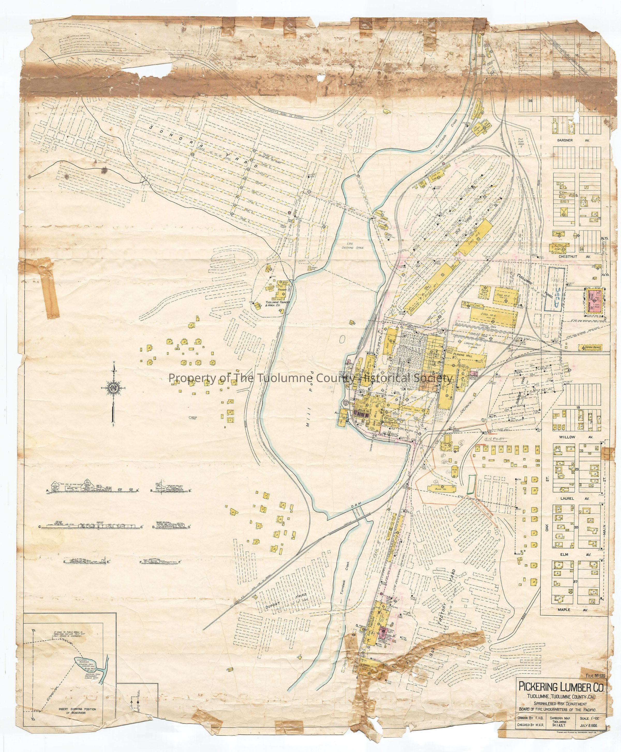
Pickering Lumber Co. Sprinklered Risk Dept. Board of Fire Underwriters of the Pacific Sanborn Map Tuolumne SH1,4,5,7 File No. 539

Complete Map

Complete Map

Name/Title

Pickering Lumber Co. Sprinklered Risk Dept. Board of Fire Underwriters of the Pacific Sanborn Map Tuolumne SH1,4,5,7 File No. 539

Entry/Object ID

M13757

Description

Sanborn Insurance Map Detailed layout of West Side Lumber Co. Plant. Shows: Mill, Mill Pond and Lumber Yard, with fire hose identification. Tuolumne, CA (David Hart description) Pickering Lumber Co. Sprinklered Risk Department Board of Fire Underwriters of the Pacific Sanborn Map Tuolumne SH1,4,5,7 File No. 539 Starting at the top or north end: we have the highway to Sonora and then the Sonora drying yard for air drying lumber. At the right most corner we have the Sonora highway. Next is the oil supply tanks for the locomotives (note that the Sierra RR has a siding in behind the oil tanks so that they can keep them supplied), then the car repair shops. Coming down from the highway south along Turnback Creek is the Hetch Hetchy & Yosemite Valleys Railways. Between Gardner and Chestnut Aves are some structures which look like residences. The ones closer to Chestnut Avenue are labeled as being barns and one as a forge. To the west is shed #2 and then the Old Yard. There are many hydrants depicted. Most are 11/4" some are bigger (21/2"). There are two tram bridges across Turnback Creek here. One is for the low tram 10' and under The other is for 30' over pond. There are three garages at the east end of the Trams. On the west bank of the log pond is the foundry. Just northeast of that is the donkey engine. This is used to drag logs around in the pond when needed. The foundry itself is housed in one building, but there are three buildings related: two are labeled Pattern St'ge (Pattern Storage I believe) . Think those are where patterns, or forms for casting, are stored Another is labeled farm implements. Below (south) that are some more lumber stacks and some more residences. On the east side of the log pond is shed #1 and shed #4 and shed #5. Next to shed #5 is a sorting shed. At the right edge of the map is the Pickering Lumber Co. office. The back half of the building is the office, the front half is the Post Office Meat Market and a General Merchandise store. After this map was made someone sketched in over two lumber stacks shed #11. This would the first map on which I have seen this shed depicted in any fashion. South of the Pickering Lumber Co. office is the Sierra Depot. South of the depot is an open area with an open grandstand at one end. And of course west of that is the wye plus tracks into shed #4 and the planing mill. Behind the planing mill to the west is the steam dry kilns. Then shed #7. machine shop, blacksmith shop.and the roundhouse. Immediately to their south is the sawmill itself. The heart of this whole complex. This map is much more detailed than the other maps of the mill site that I"ve seen. It shows many more hydrants. It shows stairs. It shows the winch in the log pond. It shows the bridge into lower Dupont yard from the area of shed 10. To the east of the sawmill complex is the Dubuque lumber drying yard. Below the Dubuque drying yard appears to be a line of residences and out buildings running east west and another running north south Together with the box factory they frame the box factory drying yard. To the west of course is the box factory itself. The box factory consists of six buildings if you count the two drying sheds to the north. There is the shook house to the south, this should be a place where they cut boards into the component parts that they assemble into a box at the box factory. The box factory itself is where they made the boxes (for fruit crates). There was also a boiler house, that provided the industrial power needed, and a block bin. I think this is where trim pieces went and they were moved in some fashion to feed the power plants. I"m guessing on this. The Carter subdivision is hinted at to the east but is not truly on this map. In the lower left portion of the map are found very small drawings which show the buildings from a side view or end view, how they are constructed or how they interact or work with the other buildings. Lastly, in the lower left corner is an inset. It's of the reservoir system. It states " Elevated reservoir estimated capacity 6,000,000 gallons 80 lbs. pressure at the sawmill. supplied continuously from flowing ditch". It shows a 20" privately owned main which shortly after making a 45 degree turn becomes a 16" pipe. On the other side is a 6" privately owned main. From my work on other maps I know that these pipes serve to supply the sawmill. (As well as any residences in the area.) Note that in the south end of Dupont yard to the east was a small building labeled Pest Ho. I assume they kept pesticides in there. To the west was another small building labeled Slaughter Ho. I assume this was for rendering animals for food. I'm guessing some on these two items. One item I've only touched on. Primarily because there isn't a starting place depicted. That's the water pipe system. For the sake of being organized I'll start in the upper left corner. In the lower portion of the Sonora lumber drying yard is a 6 inch wood water main which goes down to the foundry. A very short line goes to the north east. Along this line are hydrants with either 2' or 2 1/2 ' hose line. Apparently beyond this one line the rest of Sonora yard was protected by waterbarrels as the first line of defense in case of fire. The 6 inch water line got to the Sonora yard via the Long tram bridge across Turnback Creek. From there it made a 45 degree turn south along the tram road until it got to where the railroad tracks were curving to it and then it made a 90 degree turn to the left or east. It crossed the tracks tied into the water system at Old Yard. Old Yard is depicted as having a full sprinklererd sytem on a 6 inch pipe. On the other side of Old Yard the six inch pipe ties into a 8 inch wooden water main which feeds to the sawmill to the south and circles around the complex ending up at the sawmill again and at the box factory. There is a 12 inch wood pipe crossing east to west between shed #4 and the planing mill. There is a six inch wood pipe running from this 12 inch pipe east of shed 4 down to the box factory. Dubuque Yard is fully sprinklered. Dupont Yard and the Box Factory Yards are not. Tuolumne Yard is not sprinklered but it is a small yard and there are several hydrants well positioned around it. The two water pipes feeding into the system from the reservoir as indicated in the inset can be found between the Pickering Lumber Co. Office and the Sierra Depot. on the east edge of the map. One is a 16" wooden pipe the other is a 6" wooden pipe. The 6 inch pipe heads straight to the boiler house and sawmill to take care of their high priority needs. At the map title in the lower right hand corner we find at the top of the title box File no 539 presumably the Sanborn map number. Pickering Lumber Company Sprinklered Risk Department Board of Fire Underwriters of the Pacific Traced and printed by Sanborn Map Co. (D3561 (Rutty description) Insets: reservoir building sideviews Township/Range/Section: T1N R16E section 8

Collection

Standard Lumber Company Collection

Lexicon

Search Terms

facility map, Sanborn Sprinklered Risk Department map, Sanborn Sprinklered Risk Department map, Some 96 domiciles approximately., 6 crew quarters or boarding houses, approximately 12 buildings for the storage, fueling or repair of engines or railroad cars or related equipment., 11 lumber drying sheds (One not yet constructed)., 1 sorting table (green chain), 3 kilns, transfer tracks for kilns, 2 boilers houses (sawmill and box factory), 3 other separate buildings supporting the sawmill (fuel house, electric plant, lath mill, Machine shop, pattern shop, box factory, shook house, Sonora Rd, Maple St, Elm St, Laurel St, Willow St, Main St, Chestnut St, Gardner St, Turnback Creek, 6 inch pipe, 8 inch pipe, 12 inch pipe, 16 inch pipe