Name/Title
Townsite of CartersEntry/Object ID
M13755Description
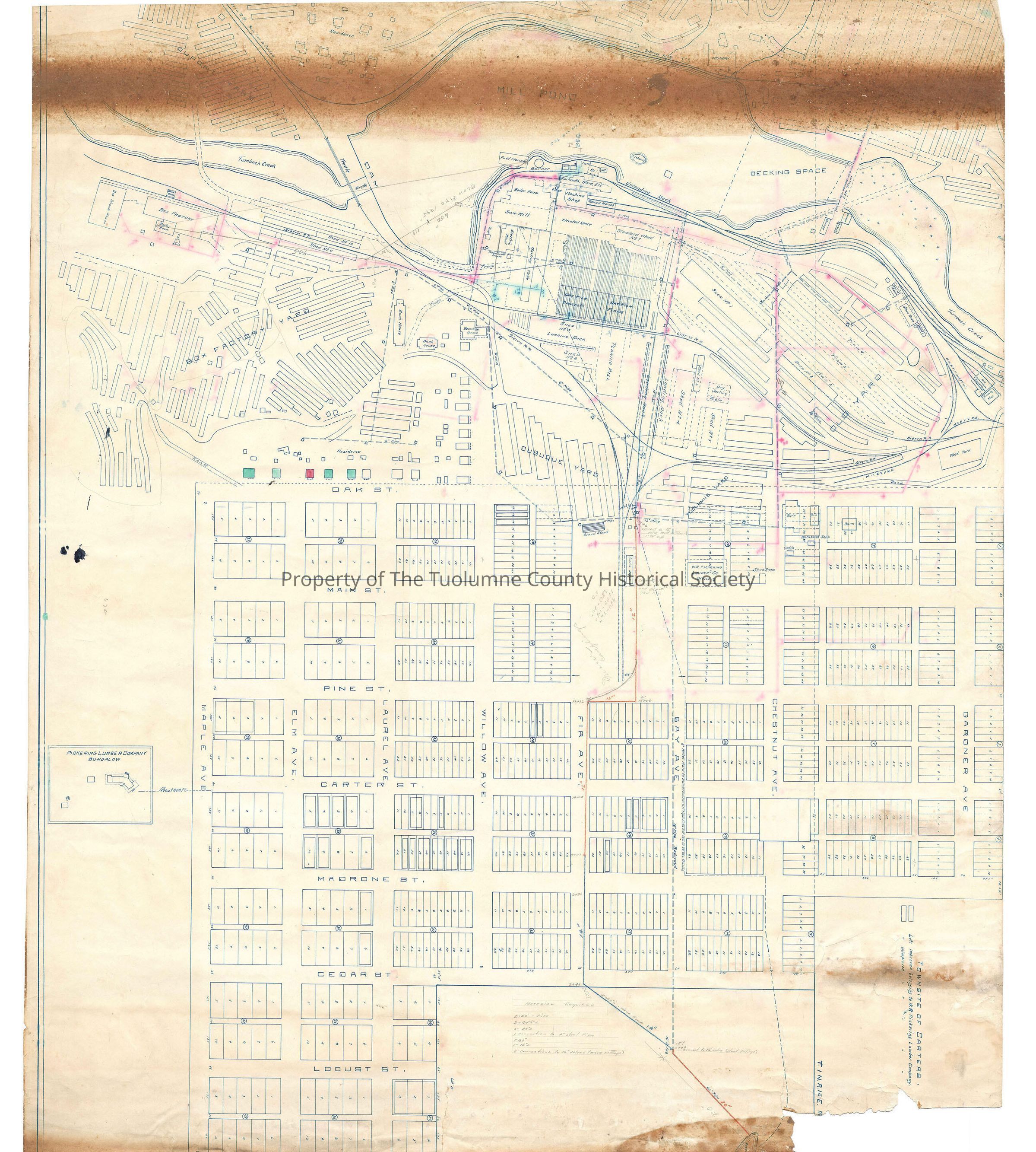
Map showing West Side Lumber Co. Mill in Tuolumne Township
(Hart description)
At the top of the map (this would be the west side of the map) are several residences and small related outbuildings. To the immediate left is the Sierra railroad and across the tracks is the the Dupont Yard one of several for stacking, storing and drying lumber. Part of this yard crosses the Railorad tracks and goes above and behind the residences. Moving east, Turnback Creek and the log pond act as a boundry to these residences and the drying yard.
There is a small road and bridge over Turnback Creek leading into Dupont Yard which ties it to the Box factory. The box factory east of Turnback Creek, has two numbered drying sheds to its north (shed No. 9 & No.10), as well as a large drying yard primarily to its east. The box shook house is to the south of the box factory and the map shows the placement of the block house to the west of the box factory between the Sierra RR spur to the box factory, and Turnback Creek. (Box shook is what the wood that is used for making wood boxes is called before it is assembled into a box. So the box shook house is probably where the lumber was cut into the pieces for a box).
Going north and following the railroad tracks, we go between sheds 9 and 10. Following the tracks further north we approach the easternmost point of the log pond.the Railroad mainline goes northeast and the mainline to Sonora goes west. There is a immediate spur off it which goes to the lumber kilns (for drying lumber). Getting back on the mainline, and heading northeast another spur is a lead to the loading dock between shed No. 3 and shed No. 8. On the right we have passed two crew bunk houses and a boarding house. The map also points out that there is a 6" water pipe buried several feet from the railroad tracks. There are stand pipes at intervals. Resuming on the mainline of the Sierra RR, at about halfway past the shed #8 the tracks split again. The first opportunity to the right is the lead to one of two tracks at Tuolumne station. The lead to the left is either the opportunity to back into the station on the other track, ready to return to Jamestown. The other opportunity is to either go into drying shed #2 or go southwest through the Old Yard then cut more south past the rear of the kilns and the rear of the No. 3 shed and tie once more with the Sierra RR trackage, having made a large loop.
The sawmill is the heart of the operations, and it draws its raw product from the log pond. Therefor it makes sense that is where we find it. Attached to it is the boiler room. This is a steam operated saw mill. The saw carriage is driven back and forth by a steam driven piston. This makes it faster than an electric one. This is all controlled by electricity so there is a room for heavy duty electric stuff. Its on the east side of the sawmill. The sort ing table is also lined out to the east. Further to the west is the blacksmith shop for repairing any thing made of iron or making any custom tools out of iron. The machine shop is for repairing machinary of all different types. Attached to the machine shop is the engine house. This is where locomotiveds are brought for repair and regular service. There are two tracks into the round house. Those tracks tie into a system of trackage winding principally along the log pond but also there is a wye which has one of its legs across and then parallel to the Sierra RR tracks. This trackage is labeled H.H. & Y.V.R. (Hetch Hetchy & Yosemite Valleys Railway). This is the official West Side Lumber Company Railway. It was a narrow gauge railroad, 36 inches. One set of tracks winds south then east around the sawmill providing service to various items needing installation and then service from time to time. Most importantly it gives a place for the engine and train to go when unloading logs from a trainload of logs.
Just north of the round house are the log unloading docks The engine would pull the cars to be unloaded onto trackage next to the log pond. I think cables were run under the load of logs and up to a winch line attached to a tall spar tree planted near the tracks. The hoist was tightened and the cables rose up and dumped the logs. At least thats one way to do it, and I'm sure they did something very close to that. I know they had a hoist tree set up there at least part of the time. Across the pond (to the west), is the foundry (where using sand castsings they could make custom iron parts). To the right of that is another drying yard untitled (I think it is the Sonora yard) Access is across a bridge titled Low Tram
Back at the sawmill, the place labeled sorting table is usually called the "green chain". Its where the boards fresh off the saws and having been trimmed for length are sorted into piles by grade. Crews of unskilled people then stack the lumber for the drying yards or kilns. I don't know enough about lumber drying to say if only certain grades were kiln dried (quite likely), or if all got some drying in the kiln, with the better grades being completely kiln dried and the other grades getting part or all of their drying out in the yards. In any case the kilns were behind the sawmill as was shed No. 7
Moving north from the sawmill and after shed No. 7 going at a 45 degree angle north east (following Turnback Creek), is shed No.1 and shed No. 2 , and the area labeled Old Yard. There are three strips labeled Tram 2, Tram 3, and tram 4. I think they were track mounted carts capable of carrying stacks of lumber for transfer to piles along those aisles. Against the tracks are some buildings. Two are labeled store room and one labeled depot. Since they are next the tracks and one is a depot I suspect its a place for the engines to get supplies other then fuel oil. Right at the edge of the map is the old roundhouse and the framing shop. To the left and below it is the H.H.Y.V.R. wye. Below that is the wood yard and then a road
Returning to the Sierra R wye just west of the depot to the south of the wye is the Dubuque Yard, its not very big. On the north side of the wye is the Tuolumne Yard. Shed 4 and 5 are on the western edge of the Tuolumne yard. To the south of Dubuque yard are some unlabeled buildings, most of which look like residences. Opposite the Sierra depot is the W. R. Pickering Lumber Co. Office
The rest of the map is devoted to housing lots on a grid. The streets varied in width from 60 to 80 feet. The avenues were 65 to 70 feet wide. The lots appear to be consistantly 125 ft. long.
Most of the lots are 25 feet wide, the better ones are 50 feet wide. These would definitly promote construction of what is termed "shotgun" housing. Long narrow houses no yards.
On the left side of the map, opposite Carter Street (a notation says about 800 feet) is a Pickering Lumber Company Bungalow. It doesn't appear ostentatious by todays standards bu its definitly a cut above the other residences portrayed on this map.
In the lower right hand corner of the map is a reservoir. The map depicts two pipes leading from the reservoir. The more northern pipe is a six inch main and there is a notation on the map that it is a six inch main and that there are numerous small hydrants not shown on the map. This line goes to the sawmill and serves the boiler and the fire hydrant and sprinkler systems for the buildings in that area.
The more southerly pipee leaves the reservoir as a 20 inch pipe. About halfway to the Carters subdivision it splits in two. The one going straight in on Bay Ave is a 16 inch redwood pipe. At Tuolumne Yard the pipe has a tee. The right leg north then west and behind shed No.1 it splits again one leg goes as a six inch pi9pe to Sonora Yard and the other goes as a 8 inch pipe to the boiler room the machine shop, the blacksmith shop and around behind the sawmill to tie into the other 6 inch pipe going to the box factory.
Back at Tuolumne yard The left pipe at that junction became an 8 inch pipe. It went south then west and joined just west of the boarding hose with the 6 inch pipe. Thereby making a circle.
(Rutty description)
Township/Range/Section: T1N R16E section 8Collection
Standard Lumber Company CollectionLexicon
Search Terms
townsite map, sawmill facilities map, Sierra Railroad, Hetch Hetchy & Yosemite Valleys Railway, Oak St, Main St, Pine St, Carter St, Madrone St, Cedar St, Locust St, Maple Ave, Elm Ave, Laurel Ave, Willow Ave, Fir Ave, Bay Ave, Chestnut Ave, Townsite of Carters, Residences, Foundry, Garages, shed #7, Blacksmith shop, Boiler room