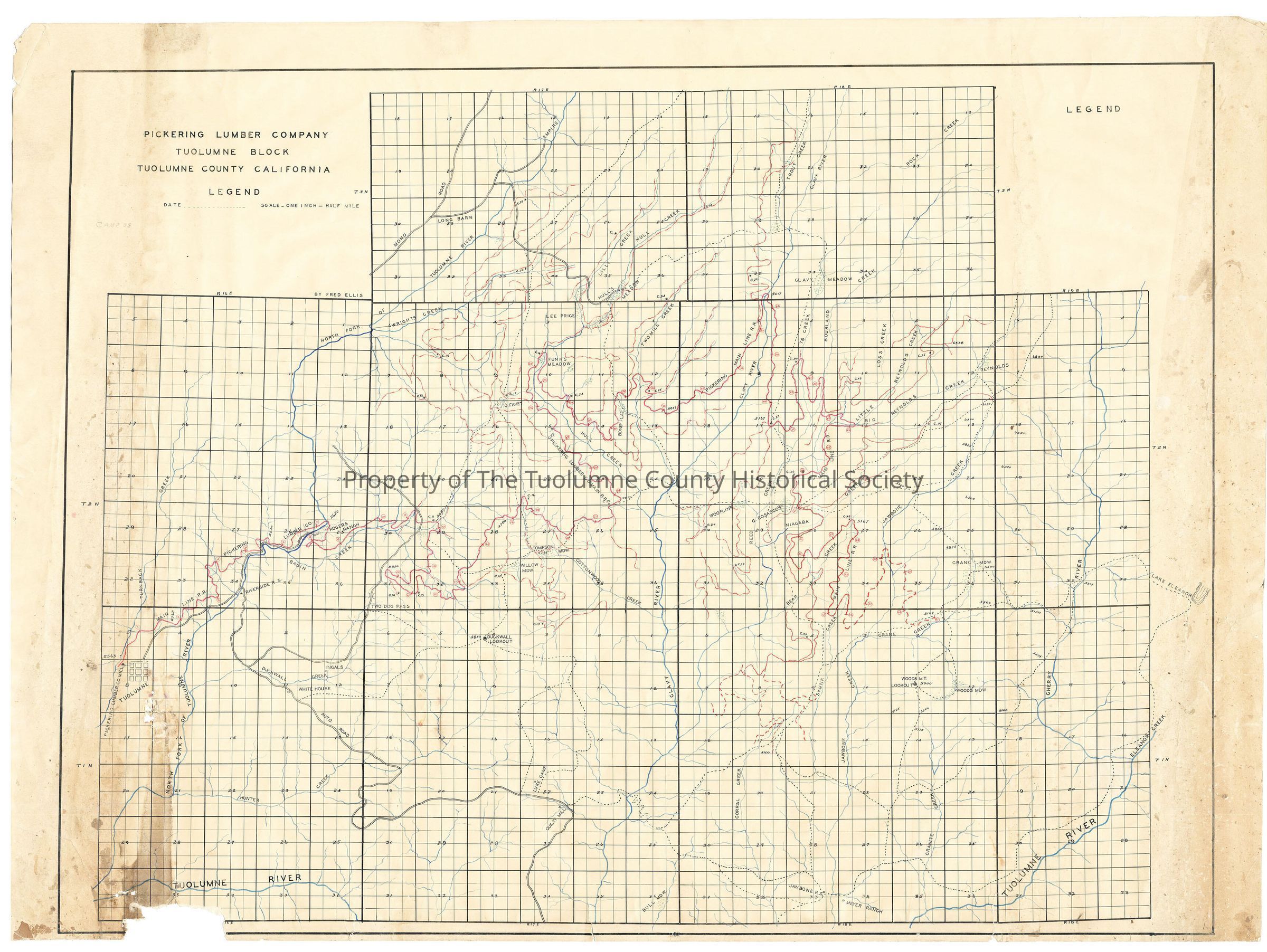
Pickering Lumber Company Tuolumne Block Tuolumne County California

Name/Title

Pickering Lumber Company Tuolumne Block Tuolumne County California

Entry/Object ID

M15212

Scope and Content

Shows right-of-way of West Side Lumber Co under Pickering ownership from Tuolumne to Skunk Creek (right-of-way penned in red ink). A truck road (Buchanon Rd.) is shown from Tuolumne to Riverside R S. There it splits, one fork going up Duckwall Creek up the Hunter Creek drainage, then along a ridge to Quilty Creek and then south. There is a junction at Duckwall Creek. That road goes over Two Dog Pass and then into Basin Creek. The other fork at Riverside R S goes up the river to Rogers Ranch. A road from Long Barn is also depicted. It follows the old foot trail into Hulls Meadow. The map of the Pickering Lumber Co. Railroad starts at the sawmill in Tuolumne. The map displays a then current rails end at mile post 56 in Skunk Creek with projected construction to mile post 61 in the Crane Creek drainage. Many spur give access to timber in Wrights Creek, Hulls Creek, Two Mile Creek, Bourland Creek and Niagara Creek just to mention a few. The map displays the old trail system which gave access to many smaller private in-holdings such as Meyer Ranch, the Price's and the lookout on Woods Ridge. Camp 8 on the mainline in Basin Creek and Camp 9 and 10 were on tributaries of Basin Creek, one of them being close to Two Dog Pass. Camp 12 & 13 were on the spur going into the Cottonwood Creek drainage. Camp 16 was located on the mainline at upper Cottonwood Creek. Camp 17 was near Fahey Meadows while Camp 24 was on a tributary of Hull Creek on the north side of the drainage. Camps 18 & 19 were on tributaries of the N Fk of the Tuolumne River just south of Wrights Creek. Camp 23 was on the mainline on the south side of Hull Creek. Camp 25 is on the Pickering mainline on the east side of Two Mile Creek near a tributary. Camp 27 is located on the mainline at about mile post 40.5 on a tributary of Reed Creek. Camp 30 is located on 76 Creek at about Mile 42.5 Camp 33 is situated on a spur above Little Reynolds Creek. Camp 36 is just past mile post 48. A spur leaves the mainline at that point. Camp 38 is on the mainline at about mile 52.5 at the head of Bear Creek. Camp 26 is on a spur on a tributary stream to the Clavey River. Camp 31 is on a spur in the upper reaches of Hull Creek at the fork of the last major splitting of the stream in section 30. Scale: 1 inch = half mile Location: Tuolumne County - North Fork of the Tuolumne River to Cherry River Township/Range/Section: T3N R17E T3N R18E, T2N R16E T2N R17E T2N R18E, T2N R19E

Collection

Standard Lumber Company Collection

Lexicon

Search Terms

forest map, logging, railroading, Clavey Rd, Buchanon Rd., Pickering Lumber Co. Railroad, Turnback Creek, North Fork Tuolumne River, Basin Creek, Wrights Creek, Lilluy Creek, Hull Creek, Two Mile Creek, Trout Creek, Clavey River, Bourland Creek, Lost Creek, 76 Creek, Little Reynolds Creek, Reynolds Creek, Jawbone Creek, Cherry River, Bear Creek, Skunk Creek, Corral Creek, Granite Creek, Camps 8, 9, 10, 12, 13, 16, 17, 24, 18, 19, 23, 25, 27, 30, 33, 36, 38, 26, 31