West Side Lumber Company DIV.

Name/Title

West Side Lumber Company DIV.

Entry/Object ID

M13700

Scope and Content

non-detailed map showing leased lands, mile post numbers and a few structure locations on ROW from Tuolumne to Camp 44. (Kauppi description) A transportation system map for the West Side Lumber Company in the mid to late 1940's. The track right of way is high lighted out to Reynolds creek for some reason. Much of that trackage is depicted as being leased (from US Forest Service) the rest is Pickering fee lands. Not sure what that means. There is a cabin noted at the River Bridge for The North Fork of the Tuolumne River & near mile post 7 . Probably for their bridge tender. Camp 8 is noted at mile post 12. Camp 24 is noted at mile post 29. A cabin is noted near mile post 38. Another is located at about mile post 44 1/2. A last one is noted at Reynolds Creek near the end of tracks, after the time of this map I assume. There is a red mark across the tracks at Reynolds Creek and it is marked End. There are no further notations on the railine. I assume that means tracks were to be removed back to Reynolds Creek. (Rutty description) Scale: 5 inches = 6 miles Location: N Fk Tuolumne River to Reynolds Creek Township/Range/Section: T3N R17E, T3N R18E, T2N R16E, T2N R17E T2N R18E T2N R19E

Collection

Standard Lumber Company Collection

Lexicon

Search Terms

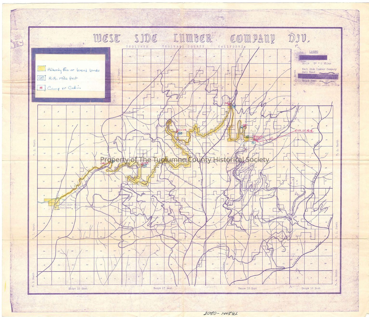
forest map, logging map, railroad map, West Side Lumber Company Railroad, Lilly Creek, Trout Creek, No Fk Tuolumne River, Basin Creek, Two Mile Creek, 76 Creek, Bourland Creek, \Cottonwood Creek, Niagara Creek, Bear Creek Clavey River, Reed Creek, Lost Creek, Reynolds Creek, Cherry River, Duckwall Creek, Hunter Creek, Corral Creek, Skunk Creek, Jawbone Creek, River Bridge Cabin, Camp * Cabin, Camp 24 Cabin, MP 38 cabin, Bourland trestle Cabin, Reynolds Creek Cabin, End of track at Reynolds Creek.