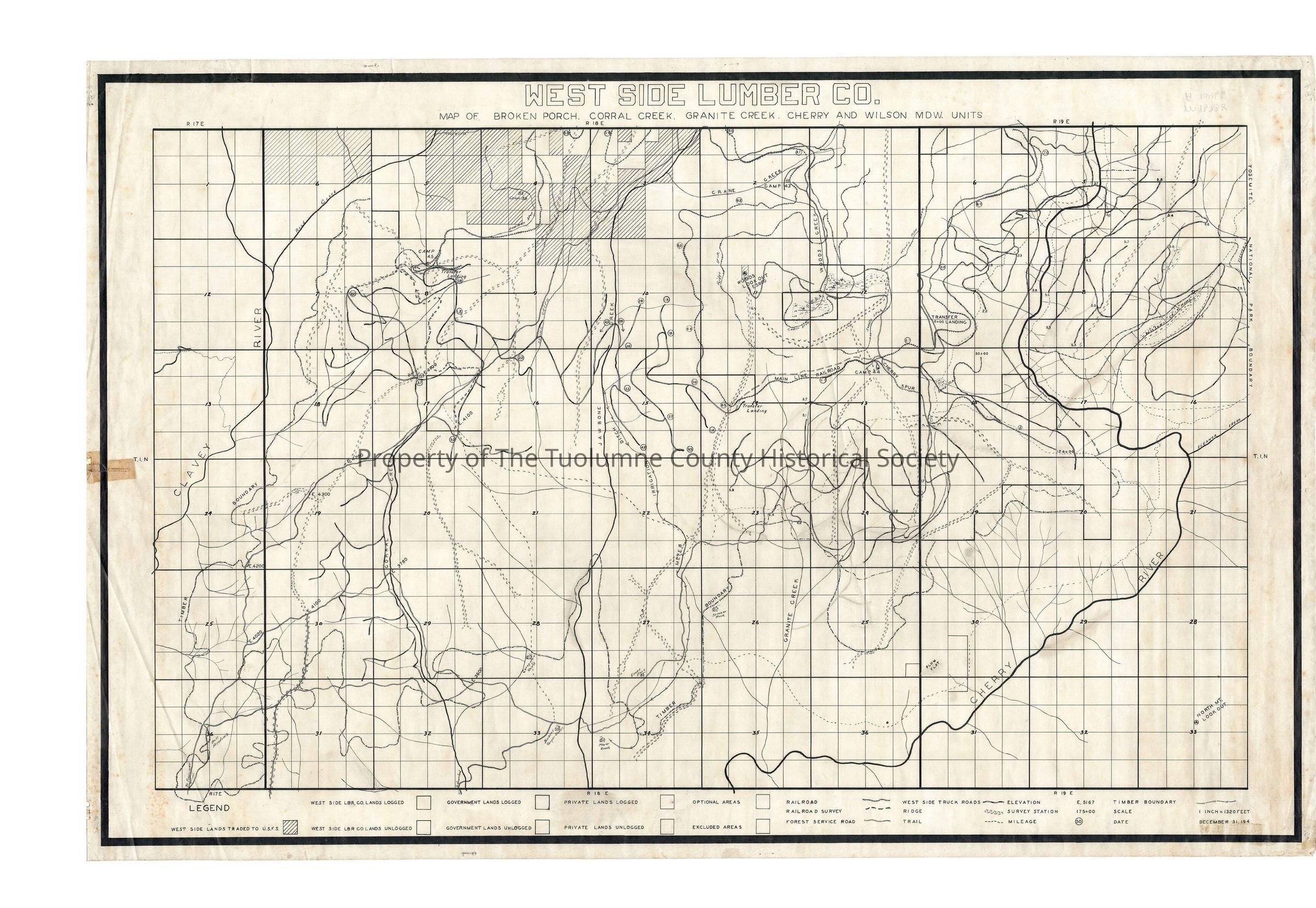
West Side Lumber Co. Broken Porch, Corral Creek, Granite Creek, Cherry and Wilson Meadow Units

Name/Title

West Side Lumber Co. Broken Porch, Corral Creek, Granite Creek, Cherry and Wilson Meadow Units

Entry/Object ID

M13738

Description

West Side Lumber Company The mainline loops in then out in section 4 at the top of the map, then loops in and out again in section 3, to finally enter the map and proceede south in section 2. It crosses Crane Creek and goes west down Crane Creek.then south to a ponit below Woods Ridge. There it turns east and at the Cherry (Creek) River drainage it heads north upstream. Initially its a mile above the Cherry River but it closes less than a 1/2 mile at its nearest. The mainline ends at almost mile post 71. (This woould be just above and beyond the Cherry Lake dam. Probabably right above the present day campground.) Camp 43 was located on a short spur on Crane Creek in section 2. Camp 44 was located in the NE 1/4 of section 13 (T1N R18E). It must have been a long term camp as it had two spurs into it one of which split making a third one. There is also a wye at the Cherry spur which starts right at the camp. Art Kauppi indicates a transfer landing was located at Camp , but the map doesn't indicate that. Camp 39 is located in section 4 on the Deadman Spur, I think on trackage which has been abandoned. Camp 45 is located in section 8 and is adjacent to a Transfer Landing. This is on the Deadman Spur. Ridge Spur leaves the mainline in Woods Creek, crosses Woods Creek and goes around the North end of Woods Ridge and down the west side crossing the south end of the ridge and then terminating. Broken Porch is a cabin in section 17in the NW 1/4. Section 33 T1S R18E shows the Jawbone Ranger Station and in section 34 SW 1/4 is the Meyer Ranch . In section 28 SW 1/4 is the Caraquero Ranch. In section 27 SW 1/4 is the Evans Place. In section 26 NW 1/4 is the Speaker Place. In section 15 T1N R18E an irrigation ditch runs approximately 2 miles from Jawbone Creek down to the Meyer Ranch. There is a transfer landing in the NW 1/4 of section 14 T1N R18E on the mainline. There is another on the mainline in section 7 SW 1/4 T1N R19E. There are two truck roads into the area. One from Tuolumne and another from Groveland. They interconnect and there are many off shoots from them so that the area is fairly well roaded. Truck logging didn't really start until about 1943. (Krieg). He indicates that the roads into the area wouldn't support large truck traffic at the time, so the Company put them on the ra lroad cars and trained them So I would suggest this as being about a 1943 to 1945 map most probably. Most likely date is1942 Township/Range/Section: T1N R18E Secs1 to 36, T1N R19E Sewcs 4 to 9, 16 to 21, 28 to 33

Collection

Standard Lumber Company Collection

Lexicon

Search Terms

forest map, logging industry, ranching, West Side Lumber Co Railroad, Road to Groveland, Road to Tuolumne, Clavey River, Reed Creek, Corral Creek, Skunk Creek, Jawbone Creek, Meyer Irrigation Ditch, Granite Creek, Cherry River, Wilson Creek, Wilson Meadows, Woods Creek, Woods Meadows, Crane Creek, Transfer Landings, Cherry Spur, Deadman Spur, Ridge Spur, Broken Porch Cabin, Caraquero Ranch, Meyer Ranch, Evans Place, Speaker Place, Jawbone Ranger Station, West Side Lumber Co., Broken Porch, Corral Creek, Granite Creek, Cherry And Wilson Mdws. Units