Name/Title
Map of VermontEntry/Object ID
2022.46.2Description
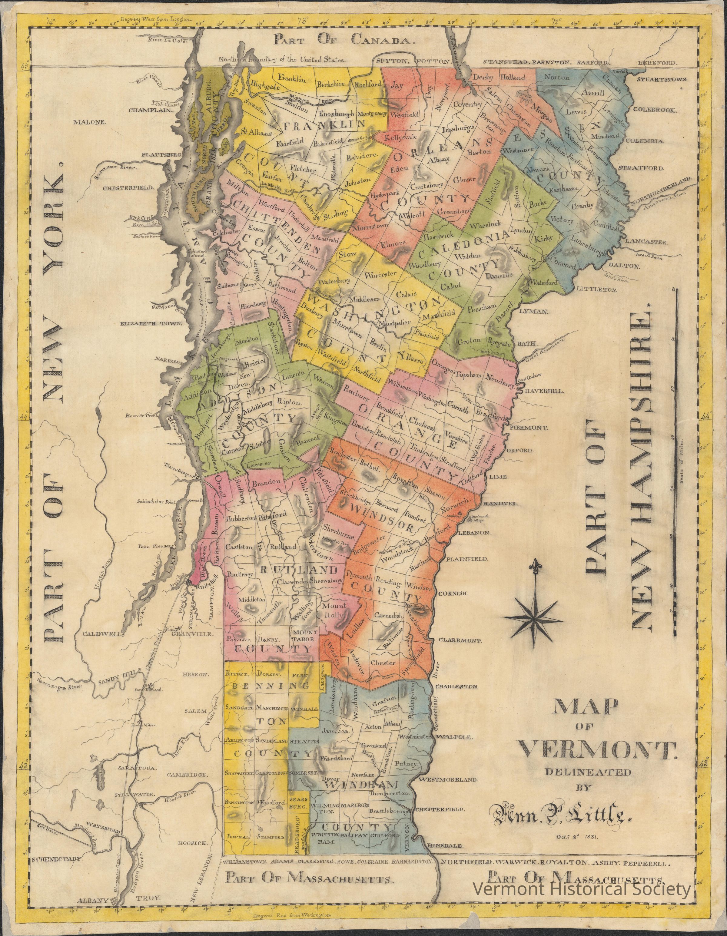
School girl Map of Vermont. The map depicts 13 of Vermont's counties (all except Lamoille) as well as all the towns within them. County borders are drawn with straight ink lines with watercolor painting used to color the interior. However, a portion of the middle of county is left white with the size of the portion varying greatly. Grand Isle County however, is depicted far different the others as it is chain of islands. The northern half of the county is colored completely green(with no spot left white) and encompasses the towns of Alburg, North Hero, and Isle La Motte, as well as the island Isle of Roky(likely modern day Butler Island).The southern half is colored gray and only includes the island/town of South Hero. Several physical and geographic features of the state are also depicted. These the states many mountains, which are shown using ridged shapes, with gray shading surrounding them meant to show their height. All the mountains are unnamed with the expectation of Killington peak, whose depiction also receives an additional artistically drawn mountain beside it. Many of the states rivers are also depicted with both major rivers(such the Onion and Missisquoi rivers) and more minor rivers(such as the Black and Williams rivers) named. Two of the states colleges also receive visual representation in the form of small college buildings. Both are simply labeled college, but it can be surmised that they are UVM and Middlebury college as they are only colleges to have existed at the time in the locations labeled. Dartmouth College is also depicted in New Hampshire and is named. The only other school depicted is that of Norwich Academy in the Town of Norwich, Vermont.
Outside of Vermont itself, several aspects of neighboring states are also depicted. The states of New Hampshire, New York and Massachusetts alongside Canada are all labeled as part of state/county. Massachusetts, New Hampshire and Canadian towns neighboring their Vermont border are all labeled on the border line and several nearby physical features are also depicted with the largest being the Connecticut river. New York receives far more detail than either Massachusetts or New Hampshire with several major landmarks(rivers and lakes) being depicted as well as town labels being placed in the spots approximating their actual geographic locations. Several military forts in southern half of New York are also Depicted including Fort Ticonderoga. Additionally, the City of Albany is also given a visual marker, using crossed lines to represent its streets. This symbol also appears in an unnamed place near West Haven Vermont. The map appears to use a privative version of the Lat/Long coordinate system Latitude being on distance from the equator and Longitude using both degrees west from Washington for long lines depicted on the top the map and long lines using distance east from London depicted at the top of the map. Next to the "Part Of Hampshire Label" the scale of the map in miles is shown.Context
Drawn by Ann P. LittleAcquisition
Accession
2022.46Source or Donor
VHS LibraryAcquisition Method
TransferLexicon
Nomenclature 4.0
Nomenclature Secondary Object Term
MapNomenclature Primary Object Term
CartographNomenclature Sub-Class
Graphic DocumentsNomenclature Class
Documentary ObjectsNomenclature Category
Category 08: Communication ObjectsDimensions
Dimension Description
Map inside lamination.Height
21-5/8 inWidth
16-7/8 inDimension Description
Laminated borderWidth
18-5/8 inLength
23-1/2 in