Name/Title
CAMDEN, ROCKPORT, AND ROCKLAND HARBORSEntry/Object ID
WHC 2018.71Scope and Content
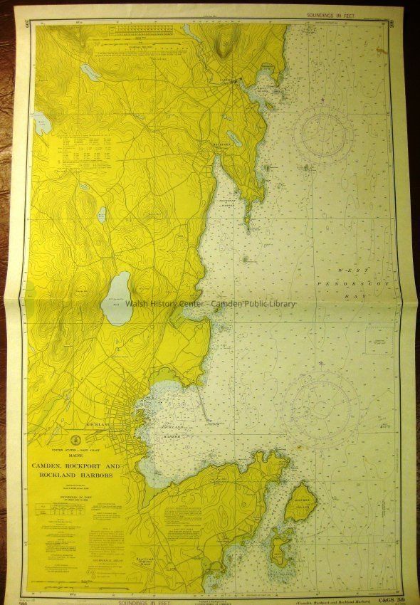
CAMDEN, ROCKPORT, AND ROCKLAND HARBORS. United States - East Coast -Maine. C&GS Chart No. 209. 5th Ed. , Sept. 1, 1973. Stamped "SOUNDINGS IN FEET." Soundings in feet at mean low water. Marine Navigation Chart from Owls Head (South) to Dillingham Ledge (North). Scales In Nautical Miles and in Yards. Folded in half. (N.O. 13/30)Collection
Camden Public Library Map CollectionCataloged By
Wyatt BerryAcquisition
Accession
WHC 2018.71Source or Donor
CPL Map CollectionAcquisition Method
Found in CollectionLexicon
Nomenclature 4.0
Nomenclature Secondary Object Term
MapNomenclature Primary Object Term
CartographNomenclature Sub-Class
Graphic DocumentsNomenclature Class
Documentary ObjectsNomenclature Category
Category 08: Communication ObjectsLOC Thesaurus for Graphic Materials
Maps, HarborsSearch Terms
Coast Guard, Navigation Chart, Soundings, Maps, Surveys, Penobscot Bay, Harbors, Rockland, Rockport, Camden, C&GS Chart No. 209Archive Details
Date(s) of Creation
1973Archive Size/Extent
26 7/8" X 41 1/2"Location
Location
Cabinet
Map CaseBuilding
Walsh History CenterCategory
PermanentDate
October 21, 2025Category
PermanentMoved By
Wyatt BerryDate
September 21, 2018Inventory
Inventoried By
Wyatt BerryInventoried Date
Sep 21, 2018General Notes
Note
Status: OK
Status By: Wyatt Berry
Status Date: 2018-09-21Created By
admin@catalogit.appCreate Date
September 18, 2018Updated By
admin@catalogit.appUpdate Date
October 27, 2025