Name/Title
EARLY SETTLED LOTS IN SOUTH THOMASTON, ME.Entry/Object ID
WHC 2018.74Scope and Content
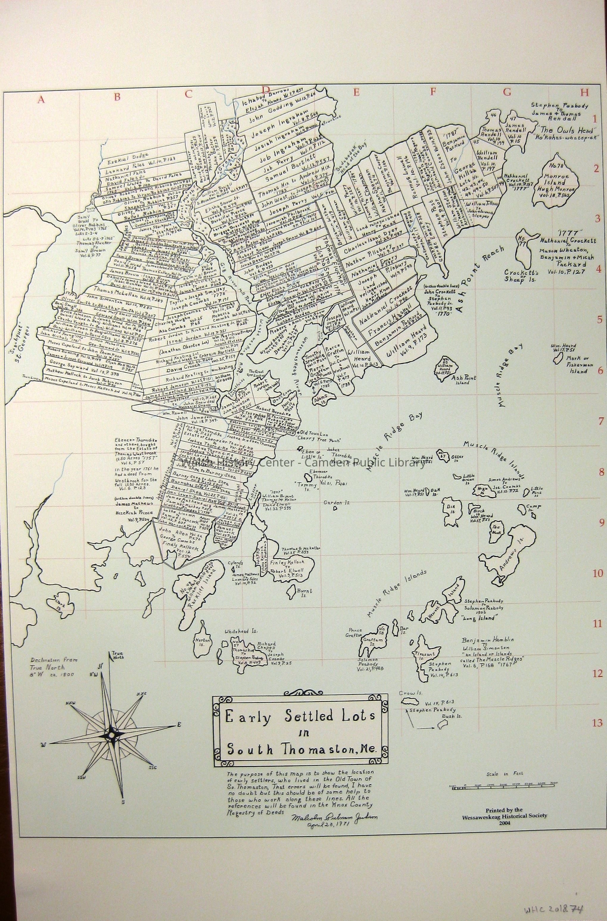
EARLY SETTLED LOTS IN SOUTH THOMASTON, ME. By Malcolm Putnam Jackson, April 28, 1971. Printed by the Wessaweskeag Historical Society, 2004. This map shows early settlers on lots in South Thomaston, with references to deeds in the Registrar of Deeds' Office. An attached note from Charles Hartman (10 Nov. 2008) says, "This information is for Library use and should not be reprinted for resale." When ordered through the Wessaweskeag Historical Society, the map is accompanied by 3 pages, that show (1) explanatory material; (2) Inhabitants of Thomaston (S. Thomaston portion) at incorporation in 1777 and (3) names and lot locations on map. The map is gridded in number/letter coordinates to facilitate locating the names and lot locations.Collection
Camden Public Library Map CollectionCataloged By
Wyatt BerryAcquisition
Accession
WHC 2018.74Source or Donor
CPL Map CollectionAcquisition Method
Found in CollectionLexicon
Nomenclature 4.0
Nomenclature Secondary Object Term
MapNomenclature Primary Object Term
CartographNomenclature Sub-Class
Graphic DocumentsNomenclature Class
Documentary ObjectsNomenclature Category
Category 08: Communication ObjectsLOC Thesaurus for Graphic Materials
Maps, SettlementsSearch Terms
SOUTH THOMASTON, Registrar of Deeds, Maps, Settlement, Malcolm Putnam JacksonArchive Details
Creator
Malcolm Putnam JacksonDate(s) of Creation
1971Archive Size/Extent
11" X 16 7/8"Location
Location
Cabinet
Map CaseBuilding
Walsh History CenterCategory
PermanentDate
October 21, 2025Category
PermanentMoved By
Wyatt BerryDate
September 21, 2018Inventory
Inventoried By
Wyatt BerryInventoried Date
Sep 21, 2018Relationships
Related Person or Organization
Person or Organization
Malcolm Putnam JacksonGeneral Notes
Note
Status: OK
Status By: Wyatt Berry
Status Date: 2018-09-21Created By
admin@catalogit.appCreate Date
September 19, 2018Updated By
admin@catalogit.appUpdate Date
October 27, 2025