Name/Title
THE MAP OF WARREN, ORIGINAL LAND GRANTS OF SAMUEL WALDOEntry/Object ID
WHC 2018.107Scope and Content
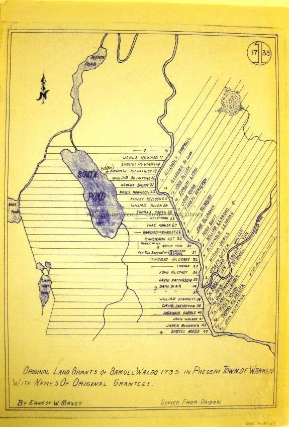
THE MAP OF WARREN, ORIGINAL LAND GRANTS OF SAMUEL WALDO - 1735. In present town of Warren, showing original lots with names of original grantees. Note says "Copied from Original."Collection
Camden Public Library Map CollectionCataloged By
Wyatt BerryAcquisition
Accession
WHC 2018.107Source or Donor
CPL Map CollectionAcquisition Method
Found in CollectionLexicon
Nomenclature 4.0
Nomenclature Secondary Object Term
MapNomenclature Primary Object Term
CartographNomenclature Sub-Class
Graphic DocumentsNomenclature Class
Documentary ObjectsNomenclature Category
Category 08: Communication ObjectsLOC Thesaurus for Graphic Materials
Maps, Land grantsSearch Terms
MAP OF WARREN, Maps, LAND GRANTS, SAMUEL WALDO, Lots, GranteesArchive Details
Date(s) of Creation
1735Archive Size/Extent
12 1/4" X 18"Location
Location
Cabinet
Map CaseBuilding
Walsh History CenterCategory
PermanentDate
October 21, 2025Category
PermanentMoved By
Wyatt BerryDate
September 21, 2018Inventory
Inventoried By
Wyatt BerryInventoried Date
Sep 21, 2018Relationships
Related Person or Organization
Person or Organization
SAMUEL WALDOGeneral Notes
Note
Status: OK
Status By: Wyatt Berry
Status Date: 2018-09-21Created By
admin@catalogit.appCreate Date
September 21, 2018Updated By
admin@catalogit.appUpdate Date
October 27, 2025